
Charleston is the largest city in the U.S. state of South Carolina, the county seat of Charleston County, and the principal city in the Charleston–North Charleston–Summerville Metropolitan Statistical Area. The city lies just south of the geographical midpoint of South Carolina's coastline on Charleston Harbor, an inlet of the Atlantic Ocean formed by the confluence of the Ashley, Cooper, and Wando rivers. Charleston had an estimated population of 138,458 as of September 2020. The estimated population of the Charleston metropolitan area, comprising Berkeley, Charleston, and Dorchester counties, was 802,122 residents as of July 1, 2019, the third-largest in the state and the 74th-largest metropolitan statistical area in the United States.

Mount Pleasant is a large suburban town in Charleston County, South Carolina, United States. In the Low Country, it is the fourth largest municipality and largest town in South Carolina, and for several years was one of the state's fastest-growing areas, doubling in population between 1990 and 2000. The population was 67,843 at the 2010 census. The estimated population in 2019 was 91,684.

Georgetown is the third oldest city in the U.S. state of South Carolina and the county seat of Georgetown County, in the Lowcountry. As of the 2010 census it had a population of 9,163. Located on Winyah Bay at the confluence of the Black, Great Pee Dee, Waccamaw, and Sampit rivers, Georgetown is the second largest seaport in South Carolina, handling over 960,000 tons of materials a year.

Arthur Middleton, of Charleston, South Carolina, was a signatory of the United States Declaration of Independence.

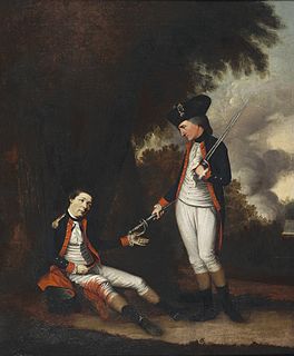
William Washington was a cavalry officer of the Continental Army during the American Revolutionary War, who held a final rank of Brigadier General in the newly created United States after the war. Primarily known as a commander of light dragoons, he led mounted troops in a number of notable battles in the Carolinas during the campaigns of 1780 and 1781.

The Ashley River is a blackwater and tidal river in South Carolina, rising from the Wassamassaw and Great Cypress Swamps in western Berkeley County. It consolidates its main channel about five miles west of Summerville, widening into a tidal estuary just south of Fort Dorchester. The river then flows for approximately 17 miles along the historical banks of the City of North Charleston before reaching peninsular Charleston. The much wider Ashley joins the Cooper River off the Battery in Charleston to form Charleston Harbor before discharging into the Atlantic Ocean. As of 2012 the land around the Ashley River is mostly undeveloped.

John Parker IV by birth inherited a spot in South Carolina's aristocracy. He was born to John Parker III and Mary Daniell, granddaughter of Governor Robert Daniell. He married Susannah Middleton, daughter of Henry Middleton and sister of Arthur Middleton. He was American planter of the Hayes Plantation and lawyer from Charleston, South Carolina. He also served as a delegate for South Carolina to the Congress of the Confederation from 1786 to 1788.

The Charles Pinckney National Historic Site is a unit of the United States National Park Service, preserving a portion of Charles Pinckney's Snee Farm plantation and country retreat. The site is located at 1254 Long Point Road, Mount Pleasant, South Carolina. Pinckney (1757-1824) was a member of a prominent political family in South Carolina. He fought in the American Revolutionary War, was held for a period as prisoner in the North, and returned to the state in 1783. Pinckney served as a delegate to the constitutional convention where he contributed to drafting the United States Constitution.
The Battle of Stono Ferry was an American Revolutionary War battle, fought on June 20, 1779, near Charleston, South Carolina. The rear guard from a British expedition retreating from an aborted attempt to take Charleston held off an assault by poorly trained militia forces under American General Benjamin Lincoln.

South Carolina Highway 61 (SC 61) is a 67-mile-long (108 km) state highway in the U.S. state of South Carolina. The highway is designated on a north–south direction, but physically travels in an east–west direction, from SC 30 in Charleston to U.S. Route 78 (US 78) near Branchville. The portion of SC 61 from Church Creek Bridge and 10 miles (16 km) north is designated a National Scenic Byway.

Middleton Place is a plantation in Dorchester County, directly across the Ashley River from North Charleston and about 15 miles (24 km) northwest of Charleston, in the U.S. state of South Carolina. Built in several phases during the 18th and 19th centuries, the plantation was the primary residence of several generations of the Middleton family, many of whom played prominent roles in the colonial and antebellum history of South Carolina. The plantation, now a National Historic Landmark District, is used as a museum, and is home to the oldest landscaped gardens in the United States.

West Ashley, or more formally, west of the Ashley, is one of the six distinct areas of the city proper of Charleston, South Carolina. As of March 2020, its estimated population was 82,341. Its name is derived from the fact that the land is west of the Ashley River.
The Raid on Combahee Ferry was a military operation during the American Civil War conducted on June 1 and June 2, 1863, by elements of the Union Army along the Combahee River in Beaufort and Colleton counties in the South Carolina Lowcountry.

Clementa Carlos "Clem" Pinckney was an American politician and pastor who served as a Democratic member of the South Carolina Senate, representing the 45th District from 2000 until his death in 2015. He was previously a member of the South Carolina House of Representatives from 1997 through 2000.
Doar is the surname of an aristocratic family in the southern United States. Prior to the American Civil War, family members were among the largest landowners in the South. The family's fortune in the U.S. originates mainly from plantations in Charleston, Georgetown, Berkeley, Orangeburg, Barnwell and Beaufort Counties, South Carolina. Among the plantations that the Doar family owned are: Doar Plantation, Doar Point Plantation, Palo Alto, Harrietta, Woodville, Walnut Grove, Montgomery, Oak Grove, Buck Hall, Egremont, Elmwood, Woodside, Hopsewee, Wedge and Windsor.

Arthur Middleton Manigault was a brigadier general in the Confederate States Army during the American Civil War.

The High Hills of Santee, sometimes known as the High Hills of the Santee, is a long, narrow hilly region in the western part of Sumter County, South Carolina. It has been called "one of the state's most famous areas". The High Hills of Santee region lies north of the Santee River and east of the Wateree River, one of the two rivers that join to form the Santee. It extends north almost to the Kershaw county line and northeasterly to include the former summer resort town of Bradford Springs. Since 1902 the town has been included in Lee County.
Ashtabula is a plantation house at 2725 Old Greenville Highway near Pendleton in Anderson County, South Carolina, USA. It has been also known as the Gibbes-Broyles-Latta-Pelzer House or some combination of one or more of these names. It was named in the National Register of Historic Places as a historic district on March 23, 1972. It is considered a significant example of a Lowcountry style plantation house built for a Charleston family in the Upstate in the early 19th century. It also is part of the Pendleton Historic District.

Rebecca Brewton Motte (1737–1815) was a plantation owner in South Carolina and townhouse owner in its chief city of Charleston. She was known as a patriot in the American Revolution, supplying continental forces with food and supplies for five years. By the end of the war, she had become one of the wealthiest individuals in the state, having inherited property from both her older brother Miles Brewton, who was lost at sea in 1775, and her husband Jacob Motte, who died in 1780.

The Emanuel African Methodist Episcopal Church, often referred to as Mother Emanuel, is a church in Charleston, South Carolina. Founded in 1817, Emanuel AME is the oldest African Methodist Episcopal church in the Southern United States. This first independent black denomination in the United States was founded in 1816 in Philadelphia, Pennsylvania.


