
DeSoto County is a county located in the Florida Heartland region of the U.S. state of Florida. As of the 2020 census, the population was 33,976. Its county seat is Arcadia.

Hardee County is a county located in the Florida Heartland of the Central Florida region in the U.S. state of Florida. As of the 2020 census, the population was 25,327. Its county seat is Wauchula.

Arcadia is a city and county seat of DeSoto County, Florida, United States. Its population was 7,637 as of the 2010 census, with an estimated population of 7,722 in 2014. Arcadia's Historic District is listed on the National Register of Historic Places.

Zolfo Springs is a town in Hardee County, Florida, United States. The population was 1,827 at the 2010 census, up from 1,641 at the 2000 census.

Fort Meade is a city in Polk County, Florida, United States. As of 2018, the population recorded by the U.S. Census Bureau is 6,203. It is part of the Lakeland–Winter Haven Metropolitan Statistical Area. The city was named for George Meade, at the time an Army lieutenant serving in Florida following the Second Seminole War. Fort Meade is home to Fort Meade Middle-Senior High School, several historic buildings, and Streamsong resort. The area is popular with kayakers and canoers.

The Bone Valley is a region of central Florida, encompassing portions of present-day Hardee, Hillsborough, Manatee, and Polk counties, in which phosphate is mined for use in the production of agricultural fertilizer. Florida currently contains the largest known deposits of phosphate in the United States.
The Southwest Florida Water Management District, is one of five regional agencies directed by Florida state law to protect and preserve water resources. Established in 1961 the agency operates and maintains several large properties and flood protection projects, sometimes with other agencies. The District's responsibilities have expanded to include managing water supply and protecting water quality and the natural systems — rivers, lakes, wetlands and associated uplands.The District's stated mission is to protect water resources, minimize flood risks and ensure the public’s water needs are met.

The Myakka River is a river in southwestern Florida. It arises near the Hardee-Manatee county line and flows southwest and then southeast through Manatee, Sarasota and Charlotte counties to Charlotte Harbor, an arm of the Gulf of Mexico. The river is 72 miles (116 km) long and has a drainage basin of 602 square miles, of which 314.7 square miles (815 km2) lies in Sarasota county. The last 20 miles (32 km) of the river is tidal and brackish.
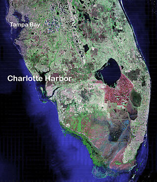
Charlotte Harbor Estuary, the second largest bay in Florida, is located on the Gulf of Mexico coast of west Florida with two thirds lying in Charlotte County, Florida and one in Lee County. The harbor's mouth is located behind Gasparilla Island, one of the many coastal barrier islands on the southwest coast of Florida, with access from the Gulf of Mexico through the Boca Grande Pass between Gasparilla Island on the north and Lacosta Island on the south. Charlotte Harbor covers about 270 sq mi (700 km2)

U.S. Highway 17 (US 17) in Florida is a north–south United States Numbered Highway that runs 317 miles (510 km) from the Punta Gorda, Florida Metropolitan Statistical Area northeast to the Jacksonville metropolitan area.

WSRQ-FM is a 5,000 watt radio station, located in the Florida Heartland. The station is licensed to the city of Zolfo Springs, in rural Hardee County. Its coverage area includes Hardee, DeSoto, and Highlands counties, serving the communities of Wauchula, Zolfo Springs, Arcadia, Sebring, Avon Park, and Lake Placid. Its studio facilities are near downtown Sarasota.

State Road 64 extends from City Road 789 near the Gulf of Mexico in Holmes Beach on Anna Maria Island in Manatee County to US 27/US 98 in Avon Park in Highlands County. State Road 64 travels from west to east through the counties of Manatee, Hardee and Highlands. It is a mostly rural two-lane highway going through only two cities, Bradenton and Zolfo Springs. It crosses the Gulf Intracoastal Waterway as well as the Braden River, Lake Manatee, and the Myakka River. East of Avon Park, a bi-county extension runs northeast into Polk County which runs through Lake Wales Ridge State Forest and terminates at the Avon Park US Air Force Base. It is designated as the Florida Cracker Trail from Bradenton to the Hardee County Line.

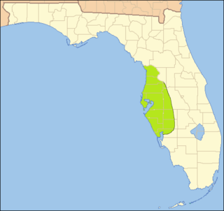
The Florida Heartland is a region of Florida located to the north and west of Lake Okeechobee, composed of six inland, non-metropolitan counties—DeSoto, Glades, Hardee, Hendry, Highlands, and Okeechobee. In 2000, The US Census Bureau recorded the population of the region at 229,509. In 2010, The US Census Bureau recorded the population of the region at 253,399, a growth rate of 11.0%. The most populous county in the region is Highlands County, and the region's largest cities are Avon Park and Sebring, both with slightly more than 10,000 people. Unlike the coastal areas to the east and west, the rural nature of the Florida Heartland is culturally closer to the Deep South than the rest of South Florida and has traditionally been inhabited by Americans of predominantly English ancestry. While located in Palm Beach County, the nearby rural cities of South Bay, Belle Glade and Pahokee as well as the census-designated place of Lake Harbor, located on the southeastern shore of Lake Okeechobee, are more associated with the Florida Heartland than the remainder of South Florida. The same could also apply to the Collier County communities of Immokalee, Ave Maria and Harker as well as to the Martin County community of Port Mayaca. Occasionally included are the southern Polk County communities of Fort Meade, Frostproof and River Ranch as well as Yeehaw Junction in Osceola County.
The following is an alphabetical list of articles related to the U.S. state of Florida.
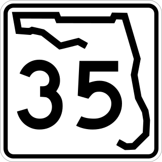
State Road 35 is a north–south state highway in the western counties of the U.S. state of Florida.
The Florida Southern Railway was a railroad that operated in Florida in the late 1800s. It was one of Florida's three notable narrow gauge railway when it was built along with the South Florida Railroad and the Orange Belt Railway. The Florida Southern was originally chartered to run from Lake City south through central Florida to Charlotte Harbor. However, with the influence of Henry B. Plant, it operated with two discontinuous segments that would be part of the Plant System, which would later become part of the Atlantic Coast Line Railroad.
The indigenous peoples of Florida lived in what is now known as Florida for more than 12,000 years before the time of first contact with Europeans. However, the indigenous Floridians living east of the Apalachicola River had largely died out by the early 18th century. Some Apalachees migrated to Louisiana, where their descendants now live; some were taken to Cuba and Mexico by the Spanish in the 18th century, and a few may have been absorbed into the Seminole and Miccosukee tribes.
The Safety Harbor culture was an archaeological culture practiced by Native Americans living on the central Gulf coast of the Florida peninsula, from about 900 CE until after 1700. The Safety Harbor culture is defined by the presence of Safety Harbor ceramics in burial mounds. The culture is named after the Safety Harbor site, which is close to the center of the culture area. The Safety Harbor site is the probable location of the chief town of the Tocobaga, the best known of the groups practicing the Safety Harbor culture.
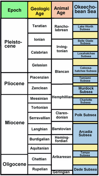
The Okeechobean Sea was a Cenozoic eutropical subsea, which along with the Choctaw Sea, occupied the eastern Gulf of Mexico basin system bounding Florida.
The history of Bartow, Florida spans over 150 years, although humans have inhabited the area for close to 12,000 years. Established in 1851 by Redding Blount, the city has gone from being a small frontier outpost vulnerable to Seminole Indian attack to being the county seat of Polk County, a county with more than half a million people.


