Peconic River

Last updated
Peconic River
Peconic in Riverhead 1.jpg
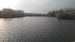
The Peconic near its mouth in Riverhead, New York
Location
Country United States
Physical characteristics
Source 
  location Brookhaven National Laboratory
  elevation249 feet (76 m)
Mouth  
  location
Riverhead/Flanders Bay
  elevation
0 ft (0 m)
Length15 mi (24 km)
Basin size75 sq mi (194 km2)
Discharge 
  average37 cubic feet (1 m3)/second

The Peconic River is a river within Suffolk County on Long Island, New York. [1] The river is located in the eastern end of Long Island. The Peconic River drains an area between the Harbor Hill Moraine and flows into Flanders Bay, which in turn connects to Peconic Bay east of Riverhead.

Contents

Peconic River Peconic River NY June 2021.jpg
Peconic River
The Peconic River near its mouth in Riverhead, New York Peconic in Riverhead.jpg
The Peconic River near its mouth in Riverhead, New York

The river originates in bogs and wetlands in central Long Island near the Brookhaven National Laboratory and flows eastward to the Peconic Bay. It is the longest river on Long Island and is almost entirely within the Central Long Island Pine Barrens publicly protected area, which was set up in 1993 to protect its relative wilderness standing.

It is fresh water until about the center of Riverhead where it becomes an estuary.

The river is slow-moving, making it ideal for canoeing and kayaking.

It forms the border between Brookhaven and Riverhead towns as well as the border between Riverhead and Southampton.

List of crossings of the Peconic River

CrossingsCarriesLocationCoordinates
Unnamed road bridgeSchultz Road
(former Suffolk CR 25)
South Manor and Calverton
Unnamed road bridgeDavid Terry Street Manorville and Calverton '
Unnamed road bridgeConnecticut Avenue
Unnamed railroad bridge Main Line of the Long Island Rail Road Calverton
Unnamed road bridgeEdwards Avenue
Unnamed Road BridgeI-495.svg I-495 (Long Island Expressway)
Peconic Lake DamDam Road
(Between South River
and Forge Roads)
Unnamed road bridgeUnnamed dead end street to
LIPA Sub-station from NY 25
Riverside and Riverhead
Unnamed road BridgeCR 94A jct.svg CR 94A (Center Drive)
Unnamed road bridgePeconic Avenue
(former NY 24-113 overlap)
Unnamed road bridgeCR 105 jct.svg CR 105 (Cross River Drive) Flanders and Riverhead

See also

Related Research Articles

<span class="mw-page-title-main">Suffolk County, New York</span> County in New York, United States

Suffolk County is the easternmost county in the U.S. state of New York. It is bordered to its west by Nassau County, to its east by Gardiners Bay and the Atlantic Ocean, to its north by Long Island Sound, and to its south by Great South Bay. The county is part of the Long Island region of the state, of which it comprises the eastern two-thirds.

<span class="mw-page-title-main">Flanders, New York</span> Hamlet and census-designated place in New York, United States

Flanders is a hamlet and a census-designated place (CDP) in Suffolk County, New York, United States. The population was 4,472 at the 2010 census. It is the location of the Big Duck.

<span class="mw-page-title-main">Riverhead, New York</span> Town in New York, United States

Riverhead is a town in Suffolk County, New York, United States, on the north shore of Long Island. Since 1727, Riverhead has been the county seat of Suffolk County, though most county offices are in Hauppauge. As of the 2020 census, the population was 35,902. The town rests on the mouth of the Peconic River, from which it derives its name. The smaller hamlet of Riverhead lies within it, and is the town's principal economic center. The town is 166 miles (267 km) southwest of Boston via the Orient Point-New London Ferry, and is 76 miles (123 km) northeast of New York City.

<span class="mw-page-title-main">Southold, New York</span> Town in New York, United States

The Town of Southold is one of ten towns in Suffolk County, New York, United States. It is located in the northeastern tip of the county, on the North Fork of Long Island. The population was 23,732 at the 2020 census. The town also contains a hamlet named Southold, which was settled in 1640.

<span class="mw-page-title-main">Peconic Bay</span> Two bays in New York, United States

The Peconic Bay is the parent name for two bays between the North Fork and South Fork of Long Island in Suffolk County, New York, United States. It is separated from Gardiners Bay by Shelter Island.

<span class="mw-page-title-main">Peconic County, New York</span> Hypothetical new county on Long Island, New York

Peconic County is a proposed new county on Long Island in the U.S. state of New York that would secede the five easternmost towns of Suffolk County: East Hampton, Riverhead, Shelter Island, Southampton and Southold, plus the Shinnecock Indian Reservation.

<span class="mw-page-title-main">North Fork (Long Island)</span> Peninsula on Long Island, New York, United States

The North Fork is a 30-mile- (48 km) long peninsula in the northeast part of Suffolk County, New York, U.S., roughly parallel with a longer peninsula known as the South Fork, both on the East End of Long Island. Although the peninsula begins east of Riverhead hamlet, the term North Fork can also refer collectively to the towns of Riverhead and Southold in their entirety.

<span class="mw-page-title-main">Long Island Central Pine Barrens</span> Natural area in Suffolk County, New York, United States

The Long Island Central Pine Barrens is a large area of publicly protected pine barrens in Suffolk County, New York, on Long Island, covering more than 100,000 acres (405 km2).

<span class="mw-page-title-main">Area codes 631 and 934</span> Area codes for Suffolk County, New York, US

Area codes 631 and 934 are the telephone area codes in the North American Numbering Plan (NANP) for Suffolk County, New York, on Long Island. Area code 631 was created in 1999 in a split from 516; and 934 was added as an overlay in 2016. Communities within the area include Babylon, Huntington, Islip, Smithtown, Brookhaven, Riverhead, Southampton, Southold, Shelter Island, and East Hampton.

<span class="mw-page-title-main">New York State Route 24</span> Highway in New York

New York State Route 24 (NY 24) is a 30.84-mile-long (49.63 km) east–west state highway on Long Island in the U.S. state of New York. The highway is split into two segments, with the longer and westernmost of the two extending 18.68 miles (30.06 km) from an interchange with Interstate 295 and NY 25 in the Queens Village section of the New York City borough of Queens to an intersection with NY 110 in East Farmingdale in the Suffolk County town of Babylon. The shorter eastern section, located in eastern Suffolk County, extends 12.16 miles (19.57 km) from an interchange with I-495 in Calverton to an intersection with County Route 80 (CR 80) in Hampton Bays.

<span class="mw-page-title-main">Outer Barrier</span> String of barrier islands dividing Long Island from the Atlantic Ocean

The Outer Barrier, also known as the Long Island and New York City barrier islands, refers to the string of barrier islands that divide the lagoons south of Long Island, New York from the Atlantic Ocean. These islands include Long Beach Barrier Island, Barnum Island, Jones Beach Island, Fire Island and Westhampton Island. The outer barrier extends 75 miles (121 km) along the South Shore of Long Island, from the Rockaway Peninsula in New York City to the east end of Shinnecock Bay in Suffolk County.

<span class="mw-page-title-main">County Route 94 (Suffolk County, New York)</span> County road in Suffolk County, New York, US

County Route 94 (CR 94) is a 4.58-mile-long (7.37 km) east–west county route connecting Calverton to Riverhead in Suffolk County, New York, in the United States. It runs from just north of the Long Island Expressway at exit 71 and a traffic circle at CR 104 in Riverside. The majority of CR 94 overlaps with New York State Route 24 (NY 24), and both CR 94 and NY 24 are signed as north–south roads. Most of CR 94 was constructed in the early 1970s; however, the designation was assigned in 1955 and officially extended to its present length in 1963.

<span class="mw-page-title-main">County Route 104 (Suffolk County, New York)</span> County road in Suffolk County, New York, US

County Route 104 (CR 104) is a 7.45-mile-long (11.99 km) county road in Suffolk County, New York, in the United States. It runs north from CR 80 in Quogue to New York State Route 24 (NY 24), CR 63 and CR 94 just outside Riverhead. Much of CR 104 runs through the David Allen Sarnoff Pine Barrens Preserve, a major New York State Conservation Area that was once owned by Radio Corporation of America. There is an access point into the preserve along CR 104 south of Riverhead.

<span class="mw-page-title-main">Carmans River</span> River in the United States

The Carmans River is a 10-mile (16 km) long river in Brookhaven, New York in Suffolk County on Long Island.

Spinney Hills is in East Quogue, New York on the eastern end of the Long Island Central Pine Barrens region. The trails in the area are sometimes used as a hiking, hunting, and off-roading area for dirt bikers, quadders, paintballers, and four-wheelers.

<span class="mw-page-title-main">East End (Long Island)</span> Region of Long Island, New York, United States

The East End of Long Island is constituted by the five townships at the eastern end of New York's Suffolk County, namely Riverhead, Southampton, Southold, Shelter Island, and East Hampton. Long Island's North Fork and South Fork are part of the East End. "The East End" is sometimes shortened as "The End", but this latter term is also applied only to Montauk, the most easterly hamlet of the contiguous land mass.

Pine Valley was a short-lived incorporated village in the Town of Southampton in Suffolk County, on Long Island, in New York, United States. The population was approximately 791 in at the time of the 1990 census.

References

40°54′53.67″N72°41′00.34″W / 40.9149083°N 72.6834278°W / 40.9149083; -72.6834278