Peggy's Cove, Nova Scotia

Last updated
Peggy's Cove
Peggys Cove Harbour 01.jpg
Peggy's Cove
Canada Nova Scotia location map 2.svg
Red pog.svg
Peggy's Cove
Location of Peggy's Cove in Nova Scotia
Coordinates: 44°29′34″N63°55′03″W / 44.49278°N 63.91750°W / 44.49278; -63.91750
CountryFlag of Canada (Pantone).svg  Canada
Province Flag of Nova Scotia.svg  Nova Scotia
Administrative district St. Margarets Bay
Founded1811
Elevation
10 m (30 ft)
Highest elevation
15 m (49 ft)
Lowest elevation
0 m (0 ft)
Population
 (2011)
  Total30 year-round residents; increases to 35 in summer season
Time zone UTC−4 (ATS)
  Summer (DST) UTC−3 (Atlantic Daylight Saving Time)
Area code 902 & 782
Highways Nova Scotia Route 333.svg Route 333

Peggy's Cove is a small rural community located on the eastern shore of St. Margarets Bay in the Halifax Regional Municipality, which is the site of Peggys Cove Lighthouse (established 1868).

Contents

Geography

Landscape of Peggy's Cove PeggysCoveLandscape.jpg
Landscape of Peggy's Cove

Peggy's Cove is 43 kilometers (26 miles) southwest of Downtown Halifax and comprises one of the numerous small fishing communities located around the perimeter of the Chebucto Peninsula.

The community is named after the cove of the same name, a name also shared with Peggy's Point, immediately to the east of the cove. The village marks the eastern point of the St. Margarets Bay.

History

Fishing boats in the harbour at Peggy's Cove Peggys Cove Harbour.jpg
Fishing boats in the harbour at Peggy's Cove

The first recorded name of the cove was Eastern Point Harbour or Peggs Harbour in 1766. The village is likely named after Saint Margaret's Bay (Peggy being a nickname for Margaret), which Samuel de Champlain named after his mother Marguerite Le Roy. [1] There has been much folklore created to explain the name.

One story suggests the village may have been named after the wife of an early settler. The popular legend claims that the name came from the sole survivor of a shipwreck at Halibut Rock near the cove. Artist and resident William deGarthe said she was a young woman while others claim she was a little girl too young to remember her name and the family who adopted her called her Peggy. [2] The young shipwreck survivor married a resident of the cove in 1800 and became known as "Peggy of the Cove", attracting visitors from around the bay who eventually named the village Peggy's Cove, after her nickname. [3]

The village was founded in 1811 when the Province of Nova Scotia issued a land grant of more than 800 acres (320 ha) to six families of German descent. The settlers relied on fishing as the mainstay of their economy but also farmed where the soil was fertile. They used surrounding lands to pasture cattle. In the early 1900s the population peaked at about 300. The community supported a schoolhouse, church, general store, lobster cannery and boats of all sizes that were nestled in the cove.

Many artists and photographers flocked to Peggy's Cove. As roads improved, the number of tourists increased. Today the population is smaller but Peggy's Cove remains an active fishing village and a favourite tourist destination.

Roads and several homes were badly damaged at Peggy's Cove in 2003 by the extensive flooding that accompanied Hurricane Juan, which also damaged the cove's breakwater. The breakwater was further washed away by Hurricane Bill in 2009, allowing waves to seriously damage a home and gift shop, and washed away one of the cove's characteristic wooden fish sheds.

In January 2021, the federal and provincial governments announced the construction of a $3.1 million accessible viewing platform at Peggy's Cove, to open in June 2021. [4] The large platform area officially opened in October 2021; while visitors are allowed to walk on the rocks too, the 1,300-square-metre deck area is safer. [5] At that time, other changes were still pending, based on a draft Master Plan for infrastructure improvement. [6]

Tourism

Peggy's cove harbour, Sept 2021 Peggy's cove harbour, Sept 2021.jpg
Peggy's cove harbour, Sept 2021
Cove ropes and rigging Peggy's Cove Ropes, Nova Scotia, Canada.jpg
Cove ropes and rigging

From its inception, the community's economy revolved around fishery. However, tourism began to overtake fishing in economic importance following the Second World War. Today, Peggy's Cove is a major tourist attraction, although its inhabitants still fish for lobster, and the community maintains a rustic undeveloped appearance. The regional municipality and the provincial government have strict land-use regulations in the vicinity of Peggy's Cove, with most property development being prohibited. Similarly there are restrictions on who can live in the community to prevent inflation of property values for year-round residents.

The historic Carpenter Gothic style St. John's Anglican Church, the only church in Peggy's Cove, is a municipally designated heritage site. [7]

The lighthouse at Sunset Peggys Cove Lighthouse, NS.jpg
The lighthouse at Sunset

The first public art gallery, tea-room, and gift shop was opened in a shack in Peggy's Cove in 1937. [8]

Geology

View of Peggy's Cove from The Whalesback, 1 km north of the community. St. Margaret's Bay is to the right, the Atlantic Ocean straight ahead. Canada-ns-peggys-cove.jpg
View of Peggy's Cove from The Whalesback, 1 km north of the community. St. Margaret's Bay is to the right, the Atlantic Ocean straight ahead.

More than 400 million years ago, in the Devonian Period, the plate tectonics movement of the Earth's crust allowed molten material to bubble up from the Earth's interior. This formed the rocks seen today and are part of the Great Nova Scotia batholith. The landscape of Peggy's Cove and surrounding areas was subsequently carved by the migration of glaciers and the ocean tides.

About 20,000 years ago, an ice ridge moved south from Canada's Arctic region covering much of North America. Along with the ebb and flow of the glaciers, the ice ridge eventually melted and shifted and in the process scooped away and scoured large sections of rock, vegetation and topsoil. As melted land glaciers flowed back to the oceans the changing tidal flows and rising sea levels filled the scarred areas with water, forming coves and inlets.

Large boulders composed of 415-million-year-old Devonian granite, called glacial erratics, were lifted by the ice and carried for long distances before being deposited upon the landscape as the ice receded, leaving rugged barrens. The movement of the glacial ice and rocks left scouring marks in the bedrock that are still visible.

Peggy's Cove has been declared a preservation area to protect its rugged beauty. The Peggy's Cove Commission Act, passed in 1962, prohibits development in and around the surrounding village and restricts development within Peggy's Cove. The area comprised about 2,000 acres (8.1 km2) stretching from Indian Harbour to West Dover and includes barrens, bogs, inland ponds, and rocky coastline.

Peggy's Cove from Swissair 111 Memorial Site PeggysCoveFromFlight111Memorial.jpg
Peggy's Cove from Swissair 111 Memorial Site

Atlantic Ocean

The Atlantic tide runs about 1.5–2 metres (4 ft 11 in – 6 ft 7 in). The ocean temperature ranges between 12 and 20° Celsius (54–68° Fahrenheit) in the summer and falls to between 0.5 and 4.5° Celsius (33–40° Fahrenheit) in the winter. The ocean moderates the air temperature over the land year round.[ citation needed ]

The shape of the ocean floor and the numerous ocean currents facilitate a rich diversity of marine life along the Atlantic coastline. The Labrador Current flowing south from the Arctic cools the ocean during the summer months. Offshore, the Gulf Stream, travelling northwest from the Caribbean to the northern Europe warms the ocean waters. The confluence of currents off Nova Scotia brings unusual Arctic and tropical species to St. Margarets Bay. Marine life includes Atlantic bluefin tuna, white-sided and white-beaked dolphins, and pinnipeds. Endangered Atlantic leatherback sea turtles are seen in the waters near shore. Endangered right whales and many other species are found in the waters.

Cultural impact

The cove was the scene of a youth novel by Bryan Doyle called You Can Pick Me up at Peggy's Cove (1976), which was made into a film directed by Don McBrearty and into a video released by Beacon Films, Inc., in 1982.

In 2016 it was announced that a Peggy's Cove–themed resort had opened in Thailand. [9]

William deGarthe

Sculptor and painter William E. deGarthe lived in Peggy's Cove. A gallery exhibiting his work is open to the public between May 1 and October 31 each year. Outside the gallery, in the William E. deGarthe Provincial Park, is a carved granite outcropping. This 30 m (100 ft) sculpture was carved by deGarthe as "a lasting monument to Nova Scotian fishermen". It depicts 32 fishermen, their wives, and children enveloped by the wings of St Elmo, the patron saint of sailors, as well as the legendary Peggy.

Swissair Flight 111

Swissair 111 memorial near Peggy's Cove Swissair 111 Memorial near Peggys Cove.jpg
Swissair 111 memorial near Peggy's Cove

On September 2, 1998, Swissair Flight 111 crashed into St. Margaret's Bay approximately eight kilometres (five miles) southwest of Peggy's Cove with the loss of all 229 aboard. The cove became one of the staging areas for first responders that were involved in the search-and-rescue response, crash recovery operation, and investigation of the crash. Many of the CCGA volunteers that were first to approach the crash site were privately owned fishing boats that were operating out of Peggy's Cove and surrounding harbours. In the days following the crash many families and media came to Peggy's Cove to see the crash site. [10] Some of the victims' family members were displeased with the plans for burial of unidentified remains, believing they should have been buried at the site of the memorial. [11]

Related Research Articles

<span class="mw-page-title-main">Liverpool, Nova Scotia</span> Community in Nova Scotia, Canada

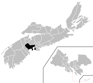
Liverpool is a Canadian community and former town located along the Atlantic Ocean of the Province of Nova Scotia's South Shore. It is situated within the Region of Queens Municipality which is the local governmental unit that comprises all of Queens County, Nova Scotia.

<span class="mw-page-title-main">Swissair Flight 111</span> Aviation accident in 1998

Swissair Flight 111 was a scheduled international passenger flight from John F. Kennedy International Airport in New York City, United States, to Cointrin Airport in Geneva, Switzerland. This flight was also a codeshare flight with Delta Air Lines. On 2 September 1998, the McDonnell Douglas MD-11 performing this flight, registration HB-IWF, crashed into the Atlantic Ocean southwest of Halifax Stanfield International Airport at the entrance to St. Margarets Bay, Nova Scotia. The crash site was 8 kilometers from shore, roughly equidistant from the small fishing and tourist communities of Peggy's Cove and Bayswater. All 229 passengers and crew on board the MD-11 were killed, making the crash the deadliest accident in the history of Swissair and the deadliest accident involving McDonnell Douglas MD-11.

<span class="mw-page-title-main">Halifax, Nova Scotia</span> Capital and most populous municipality of Nova Scotia, Canada

Halifax is the capital and largest municipality of the Canadian province of Nova Scotia, and the largest municipality in Atlantic Canada. Halifax is one of Canada's fastest growing municipalities, and as of 2022, it is estimated that the CMA population of Halifax was 480,582, with 348,634 people in its urban area. The regional municipality consists of four former municipalities that were amalgamated in 1996: Halifax, Dartmouth, Bedford, and Halifax County.

William Edward deGarthe (1907–1983) was a Finnish-born painter and sculptor who lived for much of his life in Peggy's Cove, Nova Scotia.

<span class="mw-page-title-main">St. Margarets Bay, Nova Scotia</span>

St. Margarets Bay is a bay located on the Atlantic coast of Nova Scotia, Canada on the border of Halifax County and Lunenburg County.

<span class="mw-page-title-main">Glen Haven, Nova Scotia</span> Rural Community in Nova Scotia, Canada

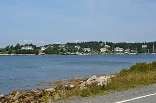
Glen Haven is a small coastal community within the Halifax Regional Municipality of Nova Scotia, Canada, about 40 km from Halifax city centre. It is situated on the shore of the St. Margarets Bay immediately adjacent to Tantallon and French Village along Route 333, also known as Peggy's Cove Road.

<span class="mw-page-title-main">Chester-St. Margaret's</span> Provincial electoral district in Nova Scotia, Canada

Chester—St. Margaret's is a provincial electoral district in Nova Scotia, Canada, that elects one member of the Nova Scotia House of Assembly. It is located on the South Shore.

The Aspotogan Peninsula is a peninsula in the eastern part of Lunenburg County, Nova Scotia, separating St. Margarets Bay in the east from Mahone Bay in the west. The peninsula was originally settled by second generation French immigrants on the east side and by second generation German immigrants on the west side. Traditionally fishing was a major industry for communities throughout the peninsula, however other primary industries such as farming and forestry were historically important as well. Shipping and shipbuilding were secondary and tertiary industries that also came into prominence during the 19th and early 20th centuries.

<span class="mw-page-title-main">Eastern Shore (Nova Scotia)</span> Region of Nova Scotia

The Eastern Shore is a region of the Canadian province of Nova Scotia. It is the Atlantic coast running northeast from Halifax Harbour to the eastern end of the peninsula at the Strait of Canso.

<i>Theodore Tugboat</i> Children’s television series

Theodore Tugboat is a Canadian children's television series about a tugboat named Theodore who lives in the Big Harbour with all of his friends. The show originated in Halifax, Nova Scotia, Canada as a co-production between the CBC, and the now defunct Cochran Entertainment, and was filmed on a model set using radio controlled tugboats, ships, and machinery. Production of the show ended in 2001, and its distribution rights were later sold to Classic Media. The show premiered in Canada on CBC Television, then went to PBS, was on Qubo in the United States, and has appeared in eighty different countries.

<span class="mw-page-title-main">Nova Scotia Route 333</span>

Route 333 is a collector road in the Canadian province of Nova Scotia.

The Lighthouse Route is a scenic roadway in the Canadian province of Nova Scotia. It follows the province's South Shore for 585 km (364 mi) from Halifax to Yarmouth.

<span class="mw-page-title-main">Hubbards, Nova Scotia</span> Place in Nova Scotia, Canada

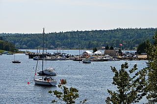
Hubbards is an unincorporated Canadian rural community on the South Shore of Nova Scotia.

Dingwall is an unincorporated area of approximately 600 residents in the Aspy Bay region of the Municipality of the County of Victoria, Nova Scotia, Canada. It is situated just off the Cabot Trail, 84.68 kilometers northeast of county seat Baddeck. The federal electoral riding is Sydney—Victoria.

<span class="mw-page-title-main">Geography of Nova Scotia</span>

Nova Scotia is a province located in Eastern Canada fronting the Atlantic Ocean. One of the Maritime Provinces, Nova Scotia's geography is complex, despite its relatively small size in comparison to other Canadian provinces.

<span class="mw-page-title-main">Indian Harbour, Nova Scotia</span>

Indian Harbour is a small fishing community of the Halifax Regional Municipality in the Canadian province of Nova Scotia on the Chebucto Peninsula. It is located between the communities of Peggy's Cove and Hackett's Cove.

<span class="mw-page-title-main">West Dover, Nova Scotia</span> Place in Nova Scotia, Canada

West Dover, is a coastal fishing community located in the Halifax Regional Municipality in the Canadian province of Nova Scotia on the Chebucto Peninsula. West Dover is situated between Peggy's Cove and East Dover on Highway 333.

<span class="mw-page-title-main">Southern Nova Scotia</span> Economic Region in Nova Scotia, Canada

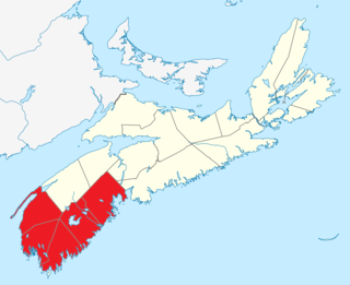
Southern Nova Scotia or the South Shore is a region of Nova Scotia, Canada. The area has no formal identity and is variously defined by geographic, county and other political boundaries. Statistics Canada, defines Southern Nova Scotia as an economic region, composed of Lunenburg County, Queens County, Shelburne County, Yarmouth County, and Digby County. According to Statistics Canada, the region had the highest decrease of population in Canada from 2009 to 2010, with a population decrease of 10.2 residents per thousand. The region also has the second-highest median age in Canada at 47.1 years old.

<span class="mw-page-title-main">Peggys Point Lighthouse</span> Lighthouse

Peggys Point Lighthouse, also known as Peggys Cove Lighthouse, is an active lighthouse and an iconic Canadian image. Located within Peggy's Cove, Nova Scotia, it is one of the busiest tourist attractions in the province and is a prime attraction on the Lighthouse Trail scenic drive. The lighthouse marks the eastern entrance of St. Margarets Bay and is officially known as the Peggys Point Lighthouse.

References

  1. Peggy's Cove: The Amazing History of a Coastal Village by Lesley Choyce, Lawrencetown Beach, Nova Scotia : Pottersfield Press, 2008. Over 150 years later DesBarres used his mother's name to rename the bay, Saint Charlotte's Bay.
  2. 'William deGarthe, This is Peggy's Cove
  3. Bruce Nunn, History with a Twist, Halifax, N.S.: Nimbus, 1998, pp. 49-53.
  4. "Accessible viewing platform, washrooms part of $3.1M Peggys Cove project". cbc.ca. January 15, 2021.
  5. "New Peggys Cove viewing platform opens with Mi'kmaw smudging ceremony". cbc.ca. October 18, 2021.
  6. "PEGGY'S COVE INFRASTRUCTURE IMPROVEMENT STRATEGY". Build Nova Scotia. September 22, 2021.
  7. Canada's Historic Places: St. John's Anglican Church
  8. Peggy's Cove Mist and Rocks, by R. Webber,2013 ISBN   1897462301
  9. Lisa Blackburn, "Iconic Peggys Cove recreated at resort in Thailand", CBC News, July 07, 2016
  10. "Daily News: 'A comforting, beautiful place'". Archived from the original on 1998-12-05. Retrieved 2018-09-22.
  11. "SwissAir Victims Displeased with Memorial Plans - Canada - CBC News". www.cbc.ca. Archived from the original on 26 April 2016. Retrieved 11 January 2022.

Sources

Coordinates: 44°29′34″N63°55′03″W / 44.49278°N 63.91750°W / 44.49278; -63.91750 (Peggys Cove)