Pelham Manor, New York

Last updated

Pelham Manor
The Manor club of Pelham.jpg
The Manor Club of Pelham
Pelham Manor, NY Seal.png
Westchester County New York incorporated and unincorporated areas Pelham Manor highlighted.svg
Location of Pelham Manor in Westchester County, New York
Coordinates: 40°53′35″N73°48′27″W / 40.89306°N 73.80750°W / 40.89306; -73.80750
Country United States
State New York
County Westchester
Town Pelham
Government
  MayorJennifer Monachino Lapey http://www.pelhammanor.org/board-of-trustees
Area
[1]
  Total1.40 sq mi (3.62 km2)
  Land1.35 sq mi (3.50 km2)
  Water0.04 sq mi (0.11 km2)
Population
 (2020)
  Total5,752
  Density4,251.29/sq mi (1,641.81/km2)
Time zone UTC-5 (Eastern (EST))
  Summer (DST) UTC-4 (EDT)
FIPS code 36-57023
Website http://www.pelhammanor.org/

Pelham Manor is an affluent village located in Westchester County, New York. As of the 2020 census, the village had a total population of 5,752. [2] It is located in the town of Pelham.

Contents

History

The Bolton Priory, Edgewood House, and Pelhamdale are listed on the National Register of Historic Places. [3]

Geography

Climate

Climate data for Pelham Manor, NY
MonthJanFebMarAprMayJunJulAugSepOctNovDecYear
Record high °F737586969799104102101898277104
Mean daily maximum °F39.242.951.462.673.881.686.083.976.165.455.143.863.5
Mean daily minimum °F20.122.329.138.447.256.862.360.853.041.234.625.641.0
Record low °F−10−521729384944342712−4−10
Average precipitation inches3.562.844.074.164.333.444.203.934.373.674.093.8046.46
Average snowfall inches9.810.96.81.4.20000.1.88.638.6
Record high °C23243036363740393832282540
Mean daily maximum °C4.06.110.817.023.227.630.028.824.518.612.86.617.5
Mean daily minimum °C−6.6−5.4−1.63.68.413.816.816.011.75.11.4−3.65.0
Record low °C−23−21−17−8−23971−3−11−20−23
Average precipitation mm90721031061108710710011193104971,180
Average snowfall cm2528173.60.5100000.252.02298
Average rainy days (≥ 0.01 in)8.58.19.39.810.99.39.08.77.66.79.29.4113.4
Source 1: Weatherbase [4]
Source 2: Homefacts (precipitation only) [5] The Weather Channel (extremes) [6]

Demographics

Historical population
CensusPop.Note
1910 852
1920 1,754105.9%
1930 4,908179.8%
1940 5,3028.0%
1950 5,3060.1%
1960 6,11415.2%
1970 6,6739.1%
1980 6,130−8.1%
1990 5,443−11.2%
2000 5,4660.4%
2010 5,4860.4%
2020 5,7524.8%
U.S. Decennial Census [7]

As of the census [8] of 2000, there were 5,466 people, 1,862 households, and 1,504 families residing in the village. The population density was 4,121.3 inhabitants per square mile (1,591.2/km2). There were 1,909 housing units at an average density of 1,439.4 per square mile (555.8/km2). The racial makeup of the village was 92.15% White, 2.12% African American, 0.07% Native American, 2.80% Asian, 0.00% Pacific Islander, 1.06% from other races, and 1.79% from two or more races. 4.63% of the population were Hispanic or Latino of any race.

There were 1,862 households, out of which 43.3% had children under the age of 18 living with them, 71.1% were married couples living together, 7.4% had a female householder with no husband present, and 19.2% were non-families. 17.5% of all households were made up of individuals, and 8.2% had someone living alone who was 65 years of age or older. The average household size was 2.93 and the average family size was 3.32.

In the village, the population was spread out, with 31.9% under the age of 19, 4.0% from 18 to 24, 25.4% from 25 to 44, 26.9% from 45 to 64, and 14.0% who were 65 years of age or older. The median age was 40 years. For every 100 females, there were 94.6 males. For every 100 females age 18 and over, there were 86.8 males.

The average household income in the village was $253,261, and the median income for a family was $154,865. [9] Males had a median income of $93,054 versus $52,424 for females. The per capita income for the village was $61,104. 4.3% of the population and 3.1% of families were below the poverty line. Out of the total population, 5.8% of those under the age of 18 and 2.7% of those 65 and older were living below the poverty line.

Economy

Shopping

Four Corners, at the intersection of Boston Post Road (US1) and Pelhamdale Avenue, boasts two mini strip malls, facing each other on either side of Boston Post Road. [10] [11]

Post Road Plaza is a shopping mall located on the Pelham Manor/Bronx border, at 895 Pelham Parkway, at the intersection of Boston Post Road (US 1), Pelham Parkway, and the Hutchinson River Parkway. [12]

Notable people

See also

Related Research Articles

<span class="mw-page-title-main">Westchester County, New York</span> County in New York, United States

Westchester County is located in the U.S. state of New York. It is the seventh most populous county in the State of New York and the most populous north of New York City. According to the 2020 United States Census, the county had a population of 1,004,456, its highest decennial count ever and an increase of 55,344 (5.8%) from the 949,113 counted in 2010. Westchester covers an area of 450 square miles (1,200 km2), consisting of six cities, 19 towns, and 23 villages. Established in 1683, Westchester was named after the city of Chester, England. The county seat is the city of White Plains, while the most populous municipality in the county is the city of Yonkers, with 211,569 residents per the 2020 census. The county is part of the Hudson Valley region of the state.

<span class="mw-page-title-main">Parkway Village, Kentucky</span> City in Kentucky, United States

Parkway Village is a home rule-class city in Jefferson County, Kentucky, United States, and a part of the Louisville Metro government. It was developed in the 1920s and incorporated in 1941. The population was 650 at the 2010 census.

<span class="mw-page-title-main">Parkway, Missouri</span> Village in Missouri, United States

Parkway is a village in Franklin County, Missouri, United States. The population was 439 at the 2010 census.

<span class="mw-page-title-main">Town and Country, Missouri</span> City in Missouri, United States

Town and Country is a city in west St. Louis County, Missouri, United States with a population of 11,640 as of the 2020 census. It is home to Missouri Baptist Medical Center,.

<span class="mw-page-title-main">Gallatin, New York</span> Town in New York, United States

Gallatin is a town in Columbia County, New York, United States. The population at 2020 was 1,628, down from 1,668 at the 2010 census. Gallatin is on the southern border of Columbia County and located 100 miles (160 km) north of New York City.

<span class="mw-page-title-main">Cortlandt, New York</span> Town in New York, United States

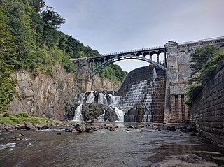
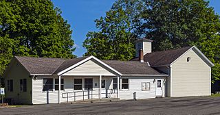
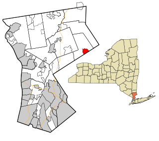
Cortlandt is a town in Westchester County, New York, United States, located at the northwestern edge of the county, at the eastern terminus of the Bear Mountain Bridge. The town includes the villages of Buchanan and Croton-on-Hudson.

<span class="mw-page-title-main">Elmsford, New York</span> Village in New York, United States

Elmsford is a village in Westchester County, New York, United States. It is part of the New York metropolitan area. Roughly one square mile, the village is fully contained within the borders of the town of Greenburgh. As of the 2010 census, the population of Elmsford was 4,664.

<span class="mw-page-title-main">Greenburgh, New York</span> Town in New York, United States

Greenburgh is a town in western Westchester County, New York. The population was 95,397 at the time of the 2020 census.

<span class="mw-page-title-main">Mount Pleasant, New York</span> Town in New York, United States

Mount Pleasant is a town in Westchester County, New York, United States, in the New York metropolitan area. As of the 2020 census, the town population was 44,436. The hamlets of Valhalla, Hawthorne, Pocantico Hills, and Thornwood, and the villages of Pleasantville, Sleepy Hollow, and a small portion of Briarcliff Manor lie within the town.

<span class="mw-page-title-main">Pleasantville, New York</span> Village in New York, United States

Pleasantville is a village in the town of Mount Pleasant, in Westchester County, New York, United States. It is located 30 miles north of Manhattan. The village population was 7,513 at the 2020 census. Pleasantville is home to the secondary campus of Pace University and to the Jacob Burns Film Center. Most of Pleasantville is served by the Pleasantville Union Free School District, with small parts of northern Pleasantville served by the Chappaqua Central School District. The village is also home to the Bedford Road School, Pleasantville Middle School, and Pleasantville High School. The region of Pleasantville commonly referred to as "The Flats" is mostly served by the Mount Pleasant Central School district.

<span class="mw-page-title-main">Rye Brook, New York</span> Village in New York, United States

Rye Brook is a village in Westchester County, New York, United States, within the town of Rye. The population was 9,347 at the 2010 census.

<span class="mw-page-title-main">Scotts Corners, New York</span> CDP in New York, United States

Scotts Corners is a hamlet located in the town of Pound Ridge in Westchester County, New York, United States. As of the 2010 census, the CDP population was 711, making Scotts Corners Westchester County's smallest census-recognized area.

<span class="mw-page-title-main">Tuckahoe (village), New York</span> Village in New York, United States

Tuckahoe is a village in Westchester County, New York, United States. One-and-a-half miles long and three-quarters of a mile wide, with the Bronx River serving as its western boundary, the Village of Tuckahoe is approximately sixteen miles north of midtown Manhattan in Southern Westchester County. As of the 2010 census, the village's population was 6,486.

<span class="mw-page-title-main">Mount Kisco, New York</span> Village and town in New York, United States

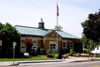
Mount Kisco is a village and town in Westchester County, New York, United States. The town of Mount Kisco is coterminous with the village. The population was 10,959 at the 2020 United States census over 10,877 at the 2010 census.

<span class="mw-page-title-main">Hamburg (village), New York</span> Village in New York, United States

Hamburg is a village in Erie County, New York, United States. The population was 9,696 at the 2020 census. The village is named after Hamburg, the second largest city in Germany. It is part of the Buffalo-Niagara Falls metropolitan area.

Hammond is a village in St. Lawrence County, New York, United States. The population was 280 at the 2010 census. The village is named after an early landowner.

<span class="mw-page-title-main">Eastchester, New York</span> Town in New York, United States

Eastchester is a town in southern Westchester County, New York, United States. The population was over 34,641 at the 2020 United States census over 32,363 at the 2010 census. There are two villages within the town: Bronxville and Tuckahoe. The town contains a census-designated place also named Eastchester, which is the whole town of Eastchester excluding Bronxville and Tuckahoe.

<span class="mw-page-title-main">Pelham (village), New York</span> Village in New York, United States

The village of Pelham is a village in Westchester County, New York, United States. The population was 6,910 at the 2010 census. It is located in the town of Pelham, which is colloquially referred to as Pelham.

<span class="mw-page-title-main">Pelham, New York</span> Town in New York, United States

Pelham is a suburban town in Westchester County, approximately 10 miles northeast of Midtown Manhattan. As of the 2020 census, it had a population of 13,078, an increase from the 2010 census. Historically, Pelham was composed of five villages and became known as "the Pelhams". Pelham currently contains two independently incorporated villages: the Villages of Pelham and Pelham Manor.

<span class="mw-page-title-main">Jefferson Valley, New York</span> Census-designated place in New York, United States

Jefferson Valley-Yorktown, commonly known as Jefferson Valley, is a census-designated place (CDP) located in the town of Yorktown in Westchester County, New York, United States. The population was 14,142 at the 2010 census. It is a hot spot for local shoppers, due to its Jefferson Valley Mall.

References

  1. "ArcGIS REST Services Directory". United States Census Bureau. Retrieved September 20, 2022.
  2. "Profile of General Population and Housing Characteristics: 2010 Demographic Profile Data (DP-1): Pelham Manor village, New York". United States Census Bureau . Retrieved November 18, 2011.
  3. "National Register Information System". National Register of Historic Places . National Park Service. March 13, 2009.
  4. "Historical Weather for New York, United States of America – Travel, Vacation and Reference Information". Canty and Associates LLC . Retrieved June 11, 2012.
  5. "Pelham Westchester County New York average temperature, sunshine and precipitation data". Homefacts.com . Retrieved June 11, 2012.
  6. "Monthly Averages for Pelham, NY (10803)". The Weather Channel. June 2012. Retrieved June 11, 2012.
  7. "Census of Population and Housing". Census.gov. Retrieved June 4, 2015.
  8. "U.S. Census website". United States Census Bureau . Retrieved January 31, 2008.
  9. United States Census
  10. "Bagel Store Interested in Four Corners Pelham Manor Location". The Pelhams - PLUS. October 12, 2015.
  11. "Pelham Manor Board Meeting - Rejection of Rezoning of Four Corners Area". YouTube (video ed.). October 29, 2014. Duration: 54:06
  12. "Post Road Plaza". Levin Management Corporation. Retrieved November 3, 2013.