Pelican Island (New Jersey)

Last updated

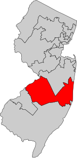
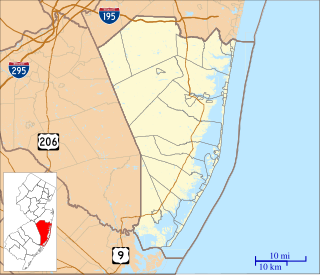
Pelican Island is an island in the Barnegat Bay wholly located in Ocean County, New Jersey. It is accessible from Toms River and Seaside Heights via the Tunney and Mathis Bridges on New Jersey Route 37. It is part of Toms River and Berkeley Township.

Barnegat Bay bay in Ocean County, United States of America

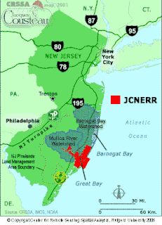
Barnegat Bay is a small brackish arm of the Atlantic Ocean, approximately 42 miles (67.2 km) long, along the coast of Ocean County, New Jersey in the United States. It is separated from the Atlantic by the long Barnegat Peninsula, as well as by the north end of Long Beach Island, popular segments of the Jersey Shore. The bay is fed by several small rivers, including the Toms River and Metedeconk River, which empty into the bay through small estuaries along its inner shore. The communities of Toms River, Silverton, and Forked River sit along the river estuaries on the bay.

Ocean County, New Jersey County in the United States

Ocean County is a county located along the Jersey Shore in the central portion of the U.S. state of New Jersey. Its county seat is Toms River. Since 1990, Ocean County has been one of New Jersey's fastest-growing counties. As of the 2018 Census estimate, the county's population was 601,651, a 4.4% increase from the 576,567 enumerated in the 2010 United States Census, making Ocean the state's sixth-most populous county. The 2010 population figure represented an increase of 65,651 (+12.8%) from the 2000 Census population of 510,916, as Ocean surpassed Union County to become the sixth-most populous county in the state. Ocean County was also the fastest growing county in New Jersey between 2000 and 2010 in terms of increase in the number of residents and second-highest in percentage growth. Ocean County was established on February 15, 1850, from portions of Monmouth County, with the addition of Little Egg Harbor Township which was annexed from Burlington County on March 30, 1891. The most populous place is Lakewood Township, with an estimated 102,682 residents as of 2017, up 10.6% from 92,843 at the 2010 Census ; while Jackson Township covers 100.62 square miles (260.6 km2), the largest total area of any municipality in the county.

New Jersey State of the United States of America

New Jersey is a state in the Mid-Atlantic and Northeastern regions of the United States. It is located on a peninsula, bordered on the north and east by the state of New York, particularly along the extent of the length of New York City on its western edge; on the east, southeast, and south by the Atlantic Ocean; on the west by the Delaware River and Pennsylvania; and on the southwest by the Delaware Bay and Delaware. New Jersey is the fourth-smallest state by area but the 11th-most populous, with 9 million residents as of 2017, and the most densely populated of the 50 U.S. states; its biggest city is Newark. New Jersey lies completely within the combined statistical areas of New York City and Philadelphia. New Jersey was the second-wealthiest U.S. state by median household income as of 2017.

Pelican Island was impacted significantly by damage from Hurricane Sandy. [1]

Hurricane Sandy Category 3 Atlantic hurricane in 2012

Hurricane Sandy was the deadliest and most destructive hurricane of the 2012 Atlantic hurricane season. Inflicting nearly $70 billion in damage, it was the second-costliest hurricane on record in the United States until surpassed by Hurricanes Harvey and Maria in 2017. The eighteenth named storm, tenth hurricane, and second major hurricane of the year, Sandy was a Category 3 storm at its peak intensity when it made landfall in Cuba. While it was a Category 2 hurricane off the coast of the Northeastern United States, the storm became the largest Atlantic hurricane on record. At least 233 people were killed along the path of the storm in eight countries.

Coordinates: 39°56′35″N74°05′18″W / 39.94306°N 74.08833°W / 39.94306; -74.08833 [2]

Geographic coordinate system Coordinate system

A geographic coordinate system is a coordinate system that enables every location on Earth to be specified by a set of numbers, letters or symbols. The coordinates are often chosen such that one of the numbers represents a vertical position and two or three of the numbers represent a horizontal position; alternatively, a geographic position may be expressed in a combined three-dimensional Cartesian vector. A common choice of coordinates is latitude, longitude and elevation. To specify a location on a plane requires a map projection.

Related Research Articles

Toms River freshwater river and estuary in Ocean County, New Jersey in the United States

The Toms River is a 41.7-mile-long (67.1 km) freshwater river and estuary in Ocean County, New Jersey in the United States.

New Jerseys 3rd congressional district

New Jersey's Third Congressional District is represented by Democrat Andy Kim.

The Seacourt Pavilion is a regional shopping center on Hooper Avenue in Toms River, New Jersey. It is right across the street from the Ocean County Mall. The mall has a gross leasable area of 253,000 sq ft (23,500 m2).

Jacques Cousteau National Estuarine Research Reserve

The Jacques Cousteau National Estuarine Research Reserve, located in southeastern New Jersey, encompasses over 110,000 acres (450 km²) of terrestrial, wetland and aquatic habitats within the Mullica River-Great Bay Ecosystem.

Jersey Shore Council

The Jersey Shore Council serves all of Ocean and Atlantic Counties, and part of Burlington and Cape May Counties. Its camp is Joseph A. Citta Scout Reservation, located in Barnegat, New Jersey.

Barnegat Inlet

Barnegat Inlet is a small inlet connecting the Barnegat Bay with the Atlantic Ocean in Ocean County, New Jersey. It separates Island Beach State Park and the Barnegat Peninsula from Long Beach Island. The Barnegat Lighthouse sits at the northern end of Long Beach Island along the inlet.

WCHR-FM

WCHR-FM, known as "105.7 The Hawk", "Classic Rock for the Jersey Shore, 105.7 The Hawk" or in reverse "105.7 The Hawk, Classic Rock for the Jersey Shore", is a Manahawkin, New Jersey radio station broadcasting at 105.7 FM with a classic rock format. It is owned by Townsquare Media.

The New Jersey Coastal Heritage Trail Route extends along eastern and southern coast of New Jersey for nearly 300 miles. It travels along the Raritan Bay from Perth Amboy to Sandy Hook, along Jersey Shore at the Atlantic Ocean to Cape May, and along the Delaware Bay to the Delaware Memorial Bridge. The trail encompasses a variety of New Jersey state parks along with facilities under the jurisdiction of the National Park Service.

The Atlantic City Bus Terminal is a regional bus station and a major stop for New Jersey Transit buses in Atlantic City, New Jersey. Located at the 1900 block of Atlantic Avenue, the station is now only half its original size, as part of it was carved out for a Polo Ralph Lauren store along the Atlantic City Outlets The Walk. The terminal contains vending machines, restrooms, a seating area, and ticket offices for New Jersey Transit and Greyhound bus lines. The Atlantic City Convention Center and Rail Terminal is located three blocks away.

WIBG (AM)

WIBG is a radio station broadcasting from Ocean City, New Jersey. The WIBG call letters were previously used in Philadelphia for a pioneering rock 'n' roll station now called WNTP.

WOBM-FM

WOBM-FM is an adult contemporary music formatted radio station known as "Ocean County's Hometown Station" broadcasting in Central New Jersey. Its variety of music stretches from artists such as Celine Dion to Billy Joel and Faith Hill. The station is owned by Townsquare Media, and is part of the Shore Group with five stations including WOBM, WJLK, WCHR-FM and WADB. Shore Group studios are at 8 Robbins Street in Toms River, New Jersey. WOBM's FM transmitter is in Bayville, New Jersey. "Ocean County's Soft Rock" officially changed formats to "Ocean County's Best Variety" in January 2015.

Barnegat Branch Trail

The Barnegat Branch Trail is a rail trail in New Jersey.

The Seaside Heights School District is a community public school district for students in kindergarten through sixth grade from Seaside Heights, in Ocean County, New Jersey, United States. The district's Board of Education is made up of five members, each elected to three-year terms.

The Seaside Park School District is a non-operating community public school district that operated one school serving students in Kindergarten through sixth grade from Seaside Park, New Jersey, United States, until it closed at the end of the 2009-10 school year.

Bergen Neck

Bergen Neck is a name for the peninsula between the Upper New York Bay and the Newark Bay in the Hudson County, New Jersey municipalities of Bayonne and Jersey City. Its southernmost tip, Bergen Point, is separated from Staten Island by the Kill van Kull, which is crossed by the Bayonne Bridge.

Gilford Park, New Jersey Unincorporated community in New Jersey, United States

Gilford Park is an unincorporated community located within Toms River in Ocean County, New Jersey, United States.

Aluminé River watercourse in Argentina

The Aluminé River is a geographical feature of Neuquén Province, Argentina. It flows southward from Lake Aluminé, near the town of Aluminé, for around 170 km (105 mi), past which it becomes a tributary of the Collón Curá River.

The Forked River Nuclear Power Plant was a proposed nuclear power plant in Lacey Township in Ocean County, New Jersey. It was proposed as a single 1,070 MW reactor in 1969 to be built by Combustion Engineering and operated by Jersey Central Power and Light. The facility would have been located on a site between JCP&L's existing Oyster Creek Nuclear Generating Station and the Garden State Parkway. Unlike the Oyster Creek Plant, the Forked River Plant would have a cooling tower to prevent the release of hot water into Oyster Creek and Barnegat Bay.

WBNJ is an American radio station broadcasting to the Monmouth/Ocean County, New Jersey market with 4,500 watts from a 150-foot tower located along New Jersey Route 72 in Barnegat, New Jersey. The station airs an adult standards music format.

References

  1. Paik, Eugene. "Volunteers clean up Pelican Island during MLK Day of Service", The Star-Ledger , January 21, 2013. Accessed April 3, 2016.
  2. "Pelican Island". Geographic Names Information System . United States Geological Survey.