Peninsula Mile Houses

Last updated

Peninsula Mile Houses began to emerge in 1849 with the organisation of a stagecoach line service connecting San Francisco and San Jose, California. They served as stagecoach stop locations for transfer, rest, and refreshment, for travelers and horses, on the rough journey that spanned at least nine hours from San Francisco to San Jose. [1]

Contents

History

The Mile House naming convention noted how far they were from important destinations or departure points. This was a tradition for inns and outlying public houses in Great Britain, and across the United States. These roadhouses were established as places to get water for horses and alcoholic drinks for people. [2]

In the 1850s Gold Rush California, the Sierra Nevada foothills had a network of Mile Houses referring to the distance to Sacramento, at 4,5,10,12,14,16,18,26, and 40 miles. [2]

The need for a stagecoach line between San Francisco and San Jose was spurred by rapid growth in the San Francisco Bay Area during the California Gold Rush. Peninsula mile houses were built along the route and named according to how many miles they sat from Portsmouth Square, [2] the San Francisco Ferry Building, [3] or Mission San Francisco de Asís. [4] Many of these simple rest stops for travelers and their horses evolved into thriving businesses, including hotels, restaurants, and saloons. [1]

In 1859 [5] the San Bruno Toll Road, later named the San Mateo Road, built by county seat [6] Redwood City businessmen, [7] was completed, merging with El Camino Real at what is today San Mateo Avenue in San Bruno. [8]

In 1875, Richard Sneath began building a dairy, later controlling 3000 acres. By 1900, his business extended to three ranches, run by 75 men. Sneath merged his operation with John Daly and others, creating the Dairy Development Company, later absorbed by the Borden Company. [8]

By 1888, water was piped from Crystal Springs Dam for Spring Valley Water Works near the San Bruno Toll Road to San Francisco. [9]

In 1889, Jenevein’s Junction House, was built at the corner of San Mateo Avenue (San Bruno Toll Road) and El Camino Real (''Old Mission Road), where the two roads met. [10] [6]

In 1906, after the earthquake and fire in San Francisco, some refugees fled south along the San Bruno Toll Road and El Camino Real (Old Mission Road), to where the two roads met, and a homeless refugee camp was set up to provide shelter. [8]

List of Peninsula Mile Houses

1 Mile House, was located at Mission and 5th Streets, San Francisco, 1 mile from Portsmouth Square [2]

1 Mile House, or Abbey House, [11] on the original mile house route, the El Camino Real route, was located near Daly City, California. [4]

3 Mile House was located on the second mile house route, the San Bruno Toll Road [6] route, near what is now the Interstate 280 (California)/Bayshore Freeway. [4]

4 Mile House was located on the second mile house route, the San Bruno Toll Road route, about a mile north of the 5 Mile House. [12]

5 Mile House is located in San Francisco at 3600 San Bruno Avenue (Between Girard Street and Wilde Avenue), [2] on the second mile house route, the San Bruno Toll Road route, but no longer has any ground-floor business operating. In its heyday, it was a prominent stop because it was the last Mile House in San Francisco city limits, and because it was at the end of the Third Street rail line, which was built in 1894. [12]

6 Mile House on today’s Bayshore Boulevard, [2] Sunnydale Avenue and Visitacion Avenue, on the second mile house route, the San Bruno Toll Road route, was the first Mile House outside of the San Francisco City limits. [12]

7 Mile House the first, [13] was built in 1853 [11] on Old Mission Road, on the original mile house route, the El Camino Real route, and located near Daly City, California.

7 Mile House was built in 1876 [14] in Brisbane, California on the second mile house route, the San Bruno Toll Road route, at the 1858 toll gate, and is the only active mile house [2] in its original location. Egidio Micheli bought 7 Mile House in 1903 [15] and sold to his brother-in-law, Palmiro Testa in 1910. [16] Camille Stuehler bought 7 Mile House in 1953 and sold to Vanessa Garcia in 2004. [17] On 6 August 1876, 7 Mile House was a hub for members of the Hayes Valley Gang. [18] During the Prohibition in the United States, in the 1920s, 7 Mile House was a speakeasy and had prostitution. [18] In the 1980s, it was raided by the FBI, as part of Ron "the Cigar" Saccos [19] horse racing and sports betting operation. [20] 7 Mile House is now a live music venue, and dog-friendly restaurant serving American, Italian, and Filipino food. [3] [21]

12 Mile House was located in South San Francisco, California. [4] [11]

San Bruno House was built in 1861 or 1862 by Richard Cunningham, at San Bruno Avenue and San Mateo Avenue, in whst is now San Bruno, but it was not named a "mile house". [6] [22] [23] [24] [25] [26] [27]

August Jenevein's Junction House, [7] was built, in 1889, at the corner of San Mateo Avenue (San Bruno Toll Road) and El Camino Real (Old Mission Road), in what is now San Bruno, where the two roads met. [28] [6]

14 Mile House (nicknamed Uncle Tom's Cabin) [11] was built in 1849 [6] at El Camino Real and Crystal Springs Creek [29] in San Bruno, California. The creek it was located by marked one of the most hazardous legs of the trip [4]

16 Mile House was built in Millbrae, California in 1872, at Center Street and El Camino Real, by the heirs of the Rancho Buri Buri grantee, Jose Sanchez, [29] and remained active in its original location until 1971 when it was demolished. In 1972, new 16 Mile House opened as a steakhouse at 448 Broadway. [29] [4] [11] [30]

17 Mile House (Millbrae Hotel, built by Perry Jones) at El Camino Real and Millbrae Avenue, in Millbrae. [31] [11] was first known to exist in 1844, became the first stop for Millbrae on the San Francisco and San Jose Railroad in 1863, and burned down in 1907. [32]

Halfway House [1] was a stage stop, in San Mateo, roughly equidistant between San Francisco and San Jose. [11]

See also

Related Research Articles

<span class="mw-page-title-main">San Francisco Peninsula</span> Peninsula in the San Francisco Bay Area

The San Francisco Peninsula is a peninsula in the San Francisco Bay Area that separates San Francisco Bay from the Pacific Ocean. On its northern tip is the City and County of San Francisco. Its southern base is Los Altos, Mountain View, in Santa Clara County, south of Palo Alto and north of Sunnyvale and Los Altos. Most of the Peninsula is occupied by San Mateo County, between San Francisco and Santa Clara counties, and including the cities and towns of Atherton, Belmont, Brisbane, Burlingame, Colma, Daly City, East Palo Alto, El Granada, Foster City, Hillsborough, Half Moon Bay, La Honda, Loma Mar, Los Altos, Menlo Park, Millbrae, Mountain View, Pacifica, Palo Alto, Pescadero, Portola Valley, Redwood City, San Bruno, San Carlos, San Mateo, South San Francisco, and Woodside.

<span class="mw-page-title-main">San Mateo County, California</span> County in California, United States

San Mateo County, officially the County of San Mateo, is a county in the U.S. state of California. As of the 2020 census, the population was 764,442. Redwood City is the county seat, the third-most populated city in the county after Daly City and San Mateo.

<span class="mw-page-title-main">Burlingame, California</span> City in California, United States

Burlingame is a city in San Mateo County, California, United States. It is located on the San Francisco Peninsula and has a significant shoreline on San Francisco Bay. The city is named after diplomat Anson Burlingame and is known for its numerous eucalyptus groves, walkable downtown area, and public school system. As of the 2020 census, the city population was 31,386.

<span class="mw-page-title-main">Millbrae, California</span> City in California, United States

Millbrae is a city located in northern San Mateo County, California, United States. To the northeast is San Francisco International Airport; San Bruno is to the northwest, and Burlingame is to the southeast. It is bordered by San Andreas Lake to the southwest. The population was 23,216 at the 2020 census.

<span class="mw-page-title-main">San Bruno, California</span> City in California, United States

San Bruno is a city in San Mateo County, California, United States, incorporated in 1914. The population was 43,908 at the 2020 United States Census. The city is between South San Francisco and Millbrae, adjacent to San Francisco International Airport and Golden Gate National Cemetery; it is approximately 12 miles (19 km) south of Downtown San Francisco.

<span class="mw-page-title-main">San Mateo, California</span> City in California, United States

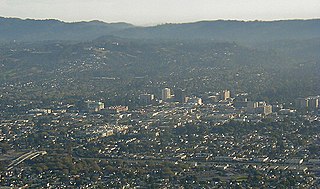
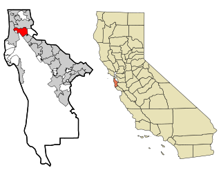
San Mateo is a city in San Mateo County, California, United States, on the San Francisco Peninsula. About 20 miles (32 km) south of San Francisco, the city borders Burlingame to the north, Hillsborough to the west, San Francisco Bay and Foster City to the east and Belmont to the south. The population was 105,661 at the 2020 census.

<span class="mw-page-title-main">South San Francisco, California</span> City in California, United States

South San Francisco is a city in San Mateo County, California, United States, located on the San Francisco Peninsula in the San Francisco Bay Area. The city is colloquially known as "South City". The population was 66,105 at the 2020 census.

<span class="mw-page-title-main">El Camino Real (California)</span> Commemorative route in California

El Camino Real is a 600-mile (965-kilometer) commemorative route connecting the 21 Spanish missions in California, along with a number of sub-missions, four presidios, and three pueblos. Historically associated with the Calle Real which terminates in Mexico City, as the former capital of New Spain and the seat of royal power for Las Californias, its southern end in the modern U.S. state of California is at Mission San Diego de Alcalá and its northern terminus is at Mission San Francisco Solano.

<span class="mw-page-title-main">Interstate 380 (California)</span> Interstate highway in California

Interstate 380 (I-380) is a short 3.3-mile (5.3 km) east–west auxiliary Interstate Highway in the San Francisco Bay Area of Northern California, connecting I-280 in San Bruno to US Route 101 (US 101) near San Francisco International Airport. The highway primarily consists of only three intersections: I-280, State Route 82, and US 101. Like the nearby I-280, I-380 never connects to I-80, its parent Interstate Highway. However, there is no rule that says that spur routes need to do so.

<span class="mw-page-title-main">Bayshore Freeway</span> Freeway in California

The Bayshore Freeway is a part of U.S. Route 101 in the San Francisco Bay Area of the U.S. state of California. It runs along the west shore of the San Francisco Bay, connecting San Jose with San Francisco. Within the city of San Francisco, the freeway is also known as James Lick Freeway, named after the California philanthropist. The road was originally built as a surface road, the Bayshore Highway, and later upgraded to freeway standards. Before 1964, it was mostly marked as U.S. Route 101 Bypass, with US 101 using the present State Route 82.

<span class="mw-page-title-main">California State Route 92</span> Highway in California

State Route 92 is a state highway in the U.S. state of California, serving as a major east-west corridor in the San Francisco Bay Area. From its west end at State Route 1 in Half Moon Bay near the coast, it heads east across the San Francisco Peninsula and the San Mateo–Hayward Bridge to downtown Hayward in the East Bay at its junction with State Route 238 and State Route 185. It has interchanges with three freeways: Interstate 280, U.S. Route 101 in or near San Mateo, and Interstate 880 in Hayward. It also connects indirectly to Interstates 238 and 580 by way of Hayward's Foothill Boulevard, which carries Route 238 and flows directly into Route 92.

<span class="mw-page-title-main">California State Route 237</span> Highway in California

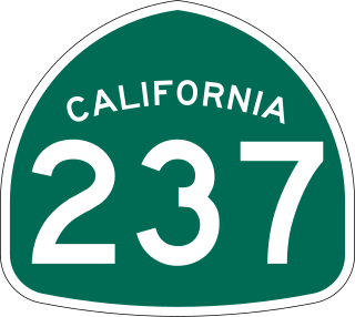
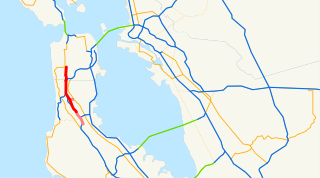
State Route 237 is a state highway in the U.S. state of California that runs from El Camino Real in Mountain View to Interstate 680 in Milpitas. Known as the Southbay Freeway for most of its length, SR 237 runs south of the San Francisco Bay, connecting the East Bay to the Peninsula.

<span class="mw-page-title-main">California State Route 82</span> Highway in California

State Route 82 is a state highway in the U.S. state of California that runs from Interstate 880 (I-880) in San Jose to I-280 in San Francisco following the San Francisco Peninsula. It is the spinal arterial road of the peninsula and runs parallel to the nearby Caltrain line along much of the route. For much of its length, the highway is named El Camino Real and formed part of the historic El Camino Real mission trail. It passes through and near the historic downtowns of many Peninsula cities, including Burlingame, San Mateo, Redwood City, Menlo Park, Palo Alto, Mountain View, Sunnyvale, and Santa Clara, and through some of the most walkable and transit-oriented neighborhoods in the region.

<span class="mw-page-title-main">South San Francisco station (BART)</span> Rapid transit station in San Francisco Bay Area

South San Francisco station is a Bay Area Rapid Transit (BART) station located in South San Francisco, California in northern San Mateo County. It consists of two main tracks and a shared underground island platform. The station is served by the Red and Yellow lines.

<span class="mw-page-title-main">Millbrae station</span> Train station in Millbrae, California, U.S.

Millbrae station is an intermodal transit station serving Bay Area Rapid Transit (BART) and Caltrain, located in Millbrae, California. The station is the terminal station for BART on the San Francisco Peninsula, served by two lines: The Red Line before 9 pm and the Yellow Line during the early morning and evening. It is served by all Caltrain services. The station is also served by SamTrans bus service, Commute.org and Caltrain shuttle buses, and other shuttles.

<span class="mw-page-title-main">Transportation in the San Francisco Bay Area</span> Overview of transportation in the San Francisco Bay Area, California

People in the San Francisco Bay Area rely on a complex multimodal transportation infrastructure consisting of roads, bridges, highways, rail, tunnels, airports, seaports, and bike and pedestrian paths. The development, maintenance, and operation of these different modes of transportation are overseen by various agencies, including the California Department of Transportation (Caltrans), the Association of Bay Area Governments, San Francisco Municipal Transportation Agency, and the Metropolitan Transportation Commission. These and other organizations collectively manage several interstate highways and state routes, eight passenger rail networks, eight trans-bay bridges, transbay ferry service, local and transbay bus service, three international airports, and an extensive network of roads, tunnels, and bike paths.

<span class="mw-page-title-main">U.S. Route 101 in California</span> U.S. Highway in California

U.S. Route 101 (US 101) is a major north–south United States Numbered Highway, stretching from Los Angeles, California, to Tumwater, Washington. The California portion of US 101 is one of the last remaining and longest U.S. Routes still active in the state, and the longest highway of any kind in California. US 101 was also one of the original national routes established in 1926. Significant portions of US 101 between the Los Angeles area and the San Francisco Bay Area follow El Camino Real, the commemorative route connecting the former Alta California's 21 missions.

<span class="mw-page-title-main">Junipero Serra Boulevard</span> Street in California

Junipero Serra Boulevard is a major boulevard in and south of San Francisco named after Franciscan friar Junipero Serra. Within the city, it forms part of the route of State Route 1, the shortest connection between Interstate 280 and the Golden Gate Bridge. The remainder, in San Mateo County, was bypassed or replaced by I-280, the Junipero Serra Freeway. The boulevard was one of several new roads built along the San Francisco Peninsula before the age of freeways, and became a state highway known as Route 237 in 1956, receiving the State Route 117 designation in the 1964 renumbering, only to be deleted from the state highway system the next year. Two other regional highways—Bayshore Highway and Skyline Boulevard—were also upgraded into or bypassed by freeways.

The Union League Golf and Country Club of San Francisco was constructed in 1929 in Millbrae, California, United States. It was one of the most ambitious golf and country club projects of its era in Northern California. It was conceived in the prosperous time that proceeded the Great Depression by a prominent group of San Francisco businessmen who would spare no expense during the design-phase of the project. The golf course was designed by Alister MacKenzie who considered it one of the top three courses on the West Coast. The unforeseen economic downturn of the Great Depression caused the club to become financially insolvent and in 1933 it was reorganized as Millbrae Country Club. In 1945 the club was named Green Hills Country Club.

Lomita Park, California was a small unincorporated community adjacent to San Bruno in San Mateo County, just west of the San Francisco International Airport. It was roughly bounded by San Felipe Avenue, El Camino Real, San Juan Avenue, and the Southern Pacific railroad tracks.

References

  1. 1 2 3 "Transportation History". sustainablesanmateo.org.
  2. 1 2 3 4 5 6 7 LaBounty, Woody (2021-10-20). "The Mile Houses of Visitacion Valley". San Francisco Heritage. Retrieved 2024-06-02.
  3. 1 2 "Luminary 2013 January" (PDF). brisbanechamber.org. Archived from the original (PDF) on 2015-10-17. Retrieved 2015-09-03.
  4. 1 2 3 4 5 6 "'Mile Houses' of the Peninsula | Local News | smdailyjournal.com". web.archive.org. 2019-02-16. Retrieved 2024-06-02.
  5. https://historysmc.org/wp-content/uploads/2020/08/La-Peninsula-San-Bruno-Summer-2014.pdf
  6. 1 2 3 4 5 6 https://web.archive.org/web/20190127154540/https://www.smdailyjournal.com/news/local/san-bruno-a-chronology/article_f93479a2-4dae-5941-89be-2cf5f9ddc36e.html
  7. 1 2 https://web.archive.org/web/20190123191409/https://www.smdailyjournal.com/news/local/the-pioneering-of-san-bruno/article_f5aa915c-83b3-5d21-bb4f-b3fa1dc5eb61.html
  8. 1 2 3 https://web.archive.org/web/20240521111305/https://www.smdailyjournal.com/news/local/san-bruno-was-always-about-transportation/article_18299477-19f1-5d99-a640-fd9280bbb2d7.html
  9. https://historysmc.pastperfectonline.com/photo/71304BAC-8715-40C6-97C9-446765905432
  10. https://calisphere.org/item/ark:/13960/t85j5q32z/
  11. 1 2 3 4 5 6 7 https://7milehouse.com/themap
  12. 1 2 3 Madonna, Joen (2010-04-18). "Viz Valley's Five Mile House: Connection to the rest of SF". SFGate. Retrieved 2020-04-27.
  13. https://www.sfweekly.com/dining/inside-the-7-mile-house-a-160-year-old-restaurant-in-the-middle-of-nowhere/article_7a7c2b02-3b6d-5829-b072-72501611a1b5.html
  14. https://web.archive.org/web/20240521052057/https://images.squarespace-cdn.com/content/v1/5621644ce4b01226f10a20ad/bd99482e-aa0a-41a9-8f9b-bd6bd7f38b6d/7+Mile+House+circa+1908.JPG?format=1500w
  15. https://7milehouse.com/thephoto
  16. https://7milehouse.com/thebar
  17. 1 2 https://www.pbssocal.org/shows/the-migrant-kitchen/the-last-mile-house-standing-7-mile-houses-more-than-160-years-of-service
  18. https://7milehouse.com/thewindow
  19. "Home". 7milehouse.com.
  20. https://ia.cpuc.ca.gov/Environment/info/aspen/jefferson_martin/pdf/App%20C-1.pdf
  21. History_of_Bayshore
  22. https://historysmc.org/wp-content/uploads/2020/08/La-Peninsula-San-Bruno-Summer-2014.pdf
  23. https://archive.org/details/csbrp_000335
  24. https://historysmc.pastperfectonline.com/Webobject/760329D3-2EC2-45C0-87A9-833332661824
  25. https://www.sanbruno.ca.gov/264/History
  26. https://calisphere.org/item/ark:/13960/t85j5q32z/
  27. 1 2 3 There is only one ‘Mile House’ left Jim Clifford @ smdailyjournal.com
  28. http://www.millbraehs.org/files/130960560.pdf
  29. http://www.millbraehs.org/files/134977073.pdf
  30. History of San Mateo County from the Earliest Times 1916