
Goat Mountain is located in the Lewis Range, Glacier National Park in the U.S. state of Montana. Goat Mountain rises above Otokomi Lake and Goat Lake in the east central section of Glacier National Park.

Mount Helen is located in the Lewis Range, Glacier National Park in the U.S. state of Montana. Mount Helen rises immediately to the northwest roughly 3,100 feet (940 m) above Upper Two Medicine Lake in the southeastern part of Glacier National Park. The Continental Divide of the Americas passes over the summit of Mount Helen.
Piegan Mountain is located in the Lewis Range, Glacier National Park in the U.S. state of Montana. Piegan Glacier is located in a cirque immediately southeast of the summit.

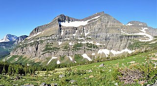
Mount Cannon is located in the Lewis Range, Glacier National Park in the U.S. state of Montana. Formerly called Goat Mountain it was renamed for the leading physiologist Dr. Walter Bradford Cannon and his wife Cornelia, who made the first recorded ascent of the mountain in 1901.

Olson Mountain, also known as Mount Olson, is a 7,913-foot-elevation mountain summit located in the Livingston Range, of Glacier National Park in the U.S. state of Montana. Olson Mountain rises more than 3,700 feet (1,100 m) above the western shore of Waterton Lake. The mountain was named for a surveyor on the International Boundary Survey, with the name officially adopted in 1929. The nearest higher peak is Campbell Mountain, 1.13 miles (1.82 km) to the north, and Citadel Peaks is two miles to the south. Precipitation runoff from the mountain drains into Olson Creek before it empties to Waterton Lake.

Stanton Mountain is a 7,750 feet (2,360 m) mountain summit located in the Livingston Range, of Glacier National Park in the U.S. state of Montana. Stanton Mountain rises more than 4,500 feet (1,400 m) above the northern shore of Lake McDonald. The mountain's name refers to Mrs. Lottie Stanton who lived near the west side of the park in the late 1800s, and with her husband operated a livery stable in historic Demersville. She was a pioneering woman who followed the construction camps during the railroad building days. The mountain's name was officially adopted in 1929. In the late 1800s it was known as Mt. Lottie Stanton. The nearest higher peak is Mount Vaught, 1.38 miles (2.22 km) to the northeast. Precipitation runoff from the mountain drains into tributaries of the Flathead River.

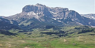
Calf Robe Mountain is a 7,948-foot-elevation (2,423-meter) mountain summit located in Glacier National Park in the U.S. state of Montana. It is situated on the Continental Divide in the Lewis Range, and can be seen from Highway 2 midway between Marias Pass and East Glacier Park. The summit is set on the border shared by Flathead County and Glacier County. Topographic relief is significant as the east aspect rises 2,500 feet in one mile. The immediate area between the mountain and highway is known for its aspen and beaver dams.

Red Crow Mountain is a 7,891-foot-elevation (2,405-meter) mountain summit located in Glacier National Park in the U.S. state of Montana. The summit is set on the border shared by Flathead County and Glacier County. It is situated on the Continental Divide so precipitation runoff from the east side of the mountain drains into Railroad Creek which is part of the Two Medicine River watershed, and the west side drains to Ole Creek, which is a tributary of Middle Fork Flathead River. It is set in the Lewis Range, 6.5 miles southwest of East Glacier Park Village. Topographic relief is significant as the east aspect rises approximately 2,000 feet in one mile. The nearest higher neighbor is Calf Robe Mountain 1.2 mile to the southeast, with Firebrand Pass forming the saddle between these two peaks.

Clyde Peak is an 8,610-foot-elevation (2,620-meter) mountain summit located in Glacier National Park in the U.S. state of Montana. The mountain straddles the border shared by Flathead County and Glacier County. It is situated on the Continental Divide so precipitation runoff from the west side of the mountain drains into Thompson Creek which is part of the Middle Fork Flathead River watershed, and the east side drains into headwaters of Red Eagle Creek, which flows to Red Eagle Lake, thence Saint Mary Lake. It is set in the Lewis Range, and the nearest higher neighbor is Mount Logan 1.44 mile to the northwest. Topographic relief is significant as the southwest aspect rises approximately 4,000 feet in one mile.
Elk Mountain is a 7,835-foot-elevation (2,388-meter) mountain summit located in Flathead County in the U.S. state of Montana. It is situated in the southern tip of Glacier National Park, in the Lewis Range, about four miles to the west side of the Continental Divide. US Highway 2 and the Hi-Line Subdivision of the BNSF Railway traverse the southern base of this mountain, approximately four miles west of Marias Pass. Topographic relief is significant as the northwest aspect rises 3,400 feet above Ole Creek in one mile. The nearest higher neighbor is Sheep Mountain 2.7 miles to the north-northwest. The mountain's name first appeared on a 1914 USGS map, and was officially adopted in 1929 by the United States Board on Geographic Names. The summit is the site of a former fire lookout that was built in the 1930s, and removed in 1963.
Scenic Point is a 7,522-foot-elevation (2,293-meter) mountain summit located in the Two Medicine area of Glacier National Park, in Glacier County, Montana, United States. It is situated in the Lewis Range, six miles northwest of East Glacier Park Village, and approximately seven miles east of the Continental Divide, with precipitation runoff from the mountain draining into the Two Medicine River watershed. Topographic relief is significant as the north aspect rises over 2,600 feet above Lower Two Medicine Lake in one mile. Access to the summit is via the Continental Divide National Scenic Trail which traverses the upper slopes of this mountain. The trail to Scenic Point was constructed by the Great Northern Railway, and the summit once hosted a locomotive bell, a Swiss Alps tradition. The mountain's name was officially adopted in 1929 by the United States Board on Geographic Names.

Spot Mountain is a 7,831-foot-elevation (2,387-meter) mountain summit located in the Two Medicine area of Glacier National Park, in Glacier County, Montana, United States. It is situated in the Lewis Range, nine miles northwest of East Glacier Park Village, and approximately five miles east of the Continental Divide. Precipitation runoff from the mountain drains into tributaries of Cut Bank Creek and Two Medicine River, which merge to form the Marias River. Topographic relief is significant as the south aspect rises nearly 3,000 feet above Lower Two Medicine Lake in two miles. The mountain's name was officially adopted in 1929 by the United States Board on Geographic Names.

Porcupine Ridge is a prominent mountain ridge located in the Goat Haunt area of Glacier National Park, in Glacier County of the U.S. state of Montana. This mountain is part of the Livingston Range, and is situated 1.5 mile east of the Continental Divide. Topographic relief is significant as the summit rises approximately 3,900 feet above Lake Frances in one mile, and nearly 5,000 feet above Waterton Lake in five miles. Precipitation runoff from the mountain drains to the Waterton River via Olson and Valentine Creeks. This geographical feature's name was officially adopted in 1911 by the United States Board on Geographic Names.

Crypt Peak is an 8,579-foot (2,615 m) mountain summit located in Glacier National Park, in Glacier County of the U.S. state of Montana. It is situated along the Canada–United States border, above Crypt Lake, and is partially within Waterton Lakes National Park. Crypt Peak is part of the Lewis Range, and is approximately three miles east of Waterton Lake. Topographic relief is significant as Crypt Peak rises over 2,100 feet above Crypt Lake in approximately one-half mile (1.6 km), and 4,400 ft (1,340 m) above Waterton Lake in three miles (4.8 km). Precipitation runoff from the mountain drains west to Waterton Lake, and east to Belly River. This geographical feature's name has not yet been officially adopted by the United States Board on Geographic Names.

Gable Peaks is a remote 7,700-foot (2,347-metre) double summit mountain located in Flathead County of the U.S. state of Montana.

Union Mountain is a 7,601-foot (2,317-metre) summit located in Flathead County of the U.S. state of Montana.

Capitol Mountain is a 7,868-foot (2,398-metre) summit located in Flathead County of the U.S. state of Montana.

Argosy Mountain is an 8,155-foot (2,486-metre) summit located in Flathead County of the U.S. state of Montana.
Old Man of the Hills is an 8,229-foot (2,508-metre) mountain summit located in Teton County of the U.S. state of Montana.
Sentinel Mountain is an 8,245-foot-elevation (2,513 meter) summit in Glacier County, Montana, United States.


