History
Originally home to an Ojibwe tribe settlement called Pequaquawaming, which means "the headland", a narrow neck of land almost surrounded by water. The point at Pequaming is in the shape of a bear; the head is called Picnic Point; the tail at the lumberyard, the legs are the two sand beaches, and the back is the shore line. The small Native American village was abandoned by the time American Fur Company trader Peter Crebassa visited in 1836. [2] [5]
In 1877, Charles Hebard and Edward Thurber purchased a large tract of land on Keweenaw Point, favored especially for its deep, protected harbor and easy access to timber. The mill began its operations with a capital of $200,000, with stock owned mostly by the Hebard and Thurber families. The mill site was initially leased from David King, Chief of the local Chippewa tribe, and then purchased from his heirs after his death. The company purchased the town site from Mrs. Eliza Bennett in 1877. [3] [4] [6]
The mill operated under the name of Hebard and Thurber until the partnership was dissolved; Hebard became sole proprietor and renamed his company Charles Hebard and Sons. [3]
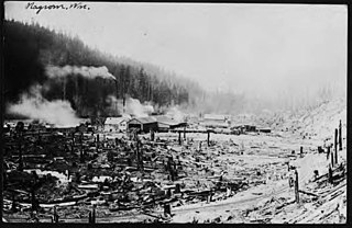
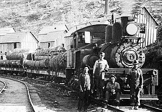
At its peak, the company employed a force of two hundred men in the mill working full time, three hundred in the surrounding woods, and nearly a thousand men in all. The company had a stumpage of 100,000 acres (400 km2) of timber lands in Marquette, Baraga, Houghton, and Keweenaw counties. The company owned the buildings and surrounding land, but was known as the "lumberman's utopia" because rent and water were free, and wood could be obtained from the mill for a very small sum per load. The town included the mill, a company store, offices, boarding houses, hotel, livery stable, a bowling alley, bath houses, churches, schools, parks, a band and orchestra, ice rink, and over 100 houses. [3] [2] [5] [6]
The Pequaming mill was the first large-scale lumbering and milling operation in the Lake Superior region, and in the years between 1880 and 1900, the mill cut an average of over 30,000,000 board feet (70,000 m3), 25,000,000 board feet (59,000 m3) in boards and 7,000,000 board feet (20,000 m3) in lath). When officials realized the white pine supply was nearly exhausted, they switched to hemlock and cedar. The pine was made into 1x4 lumber, the cedar into shingles, and hemlock into lath; other products included rail ties and hemlock bark for tanneries. For shipment, the products were loaded into box cars, which were placed onto scows and towed across the bay to Baraga, and then shipped by rail to their destinations. The original sawmill operated until 1887, when it burned in a fire of unknown origins, and was replaced by a larger mill within 60 days. [3] [4]
When Charles Hebard died in 1904, his sons Daniel and Charles inherited the company and continued operations. "The Bungalow", which later became Henry Ford's summer home, was constructed in 1913. [3]
In 1922, the Hebards were approached by Ford Motor Company, who wanted to purchase their timber stands only. Mindful of Pequaming's future, the Hebards convinced Ford to purchase the mill and surrounding town as well, and entered into secret negotiations with the hope of completing the sale before operations began. On September 8, 1923, Ford Motor Company purchased the mill and surrounding town for the sum of $2,850,000; the purchase included the double band sawmill, lath and shingle mills, 40,000 acres (160 km2) of timber land, 30,000,000 board feet (70,000 m3) of lumber, 3,000,000 board feet (7,000 m3) of cut logs, the town land and buildings, the railroad, and towing and water equipment. [4] [3] [6] [5]
Renovations on the mill began, and entailed removing the lath and shingle mills, altering the eastern face, dismantling the old burner, and adding a new powerhouse on the west side that housed a 1,000 horsepower (750 kW) triple expansion marine engine from a World War I Liberty boat. After repair and refitting, the sawmill reopened on September 24, with a work force that received $5 per day for an eight-hour shift instead of the previous $3.50 for a longer day.
By the end of February 1925, Ford had connected the Hebard railroad to the Ford railroad in L'Anse, allowing each plant to specialize in one type of wood. Lumber from the Pequaming mill was generally shipped by water to plants in Dearborn, Edgewater, and Chester, mostly in the form of crating lumber. The better grades of lumber were sent by rail to Iron Mountain for use in the auto manufacturing plants. During its peak, the sawmill provided flooring for floorboards, truck boxes, and wood panels for station wagons.
By 1933, car sales had decreased enough due to the Great Depression, that the demand for lumber was nearly nonexistent. As the mill was idled during that period, Henry Ford created other work for residents by establishing a cooperative farm east of town. As an additional measure, the company store adjusted its food prices and donated clothing and shoes to employees and their families. Ford also used the town as a model for his theories on self-reliance and education; he established a vocational school in his summer home (to be used during the school year), and also opened four one-room elementary and intermediate schools in September 1935. In 1937, the company built a high school, which contained state-of-the-art home economics food and clothing labs and a library, as well as the first fluorescent lights in a Michigan school. [4]
In 1935, the company decided to ship its products by truck, and instituted "just in time" shipping for its logging operations. After the United States entered in World War II, the company's ships were diverted, which resulted in the lumber being trucked to L'Anse and then shipped by rail. However, a shortage of truck tires and increased shipping costs prompted the company to close the mill on October 9, 1942, with the last logs sawed on October 28.

Baraga County is a county in the Upper Peninsula in the U.S. state of Michigan. As of the 2020 census, the population was 8,158, making it Michigan's fifth-least populous county. The county seat is L'Anse. The county is named after Bishop Frederic Baraga, a Catholic missionary who ministered to the Ojibwa Indians in the Michigan Territory.

L'Anse Township is a civil township of Baraga County in the U.S. state of Michigan. As of the 2020 census, the township population was 3,551. The township contains Mount Arvon and Mount Curwood, Michigans highest and second-highest points, as well as the village of L'Anse.

The L'Anse Indian Reservation is the land base of the federally recognized Keweenaw Bay Indian Community of the historic Lake Superior Band of Chippewa Indians.. The reservation is located primarily in two non-contiguous sections on either side of the Keweenaw Bay in Baraga County in the Upper Peninsula of the U.S. state of Michigan. The Keweenaw Bay Community also manages the separate Ontonagon Indian Reservation.

Alberta is an unincorporated community in L'Anse Township of Baraga County in the U.S. state of Michigan. It is situated on US Highway 41 (US 41) about eight miles (13 km) south of the village of L'Anse at 46°38′37″N88°28′46″W. Alberta is the site of the Ford Center, managed by the Michigan Technological University College of Forest Resources and Environmental Science.
M-35 is a state trunkline highway in the Upper Peninsula (UP) of the US state of Michigan. It runs for 128 miles (206 km) in a general north–south direction and connects the cities of Menominee, Escanaba, and Negaunee. The southern section of M-35 in Menominee and Delta counties carries two additional designations; M-35 forms a segment of the Lake Michigan Circle Tour, and it is the UP Hidden Coast Recreational Heritage Trail, which is a part of what is now called the Pure Michigan Byways Program. Along the southern section, the highway is the closest trunkline to the Green Bay, a section of Lake Michigan. The northern section of the highway turns inland through sylvan areas of the UP, connecting rural portions of Delta and Marquette counties.
Aura is a small unincorporated community in Arvon Township of Baraga County in the U.S. state of Michigan. The area is approximately 12 miles (19 km) northeast of L'Anse and four miles (6 km) east of Pequaming.
Portage Point is an unincorporated summer resort area of Onekama Township, Manistee County in the U.S. state of Michigan. It includes the site of the first town on Portage Lake at 44°21′43″N86°15′42″W It is located on the narrow strip of land between Portage Lake and Lake Michigan developed by the Portage Point Association. A post office operated in summers from August 1917 until September 1921.
Shelldrake is a ghost town in Whitefish Township, Chippewa County, Michigan, United States, about 8 miles (13 km) south of Whitefish Point, Michigan at the mouth of the Shelldrake River on Whitefish Bay. It is listed on the Michigan Historic Register. Prior to European settlement it supported a seasonal Native American fishing village. In the 1890s and early 1900s, it was a thriving sawmill town during peak logging years on the Tahquamenon River watershed. By the 1920s repeated fires and the decline of lumbering led to its demise. Today it is a privately owned ghost town with only a few weathered, original buildings.
Nagrom was a town in King County, Washington, United States.
Rockport is a former settlement in an unincorporated area of Mendocino County, California. It is located 7.25 miles (12 km) north-northwest of Westport, at an elevation of 30 feet.

Andersonia is an unincorporated community in Mendocino County, California. It is located near U.S. Route 101 on the South Fork of the Eel River 1 mile (1.6 km) north-northwest of Piercy, at an elevation of 541 feet.

The Fort Bragg and Southeastern Railroad was formed by Atchison, Topeka and Santa Fe Railway as a consolidation of logging railways extending inland from Albion, California on the coast of Mendocino County. The railroad and its predecessors operated from August 1, 1885 to January 16, 1930. The line was merged into the regional Northwestern Pacific Railroad in 1907; but planned physical connection was never completed.

Pine Creek Gorge, sometimes called The Grand Canyon of Pennsylvania, is a 47-mile (76 km) gorge carved into the Allegheny Plateau by Pine Creek in north-central Pennsylvania.
Porter's Mills, also called Porterville, was a logging boomtown in Eau Claire County, Wisconsin, United States, between Brunswick and Eau Claire, at 44° 46' 15" N 91° 34' 01" W. at an elevation of 771 feet.
Morse is an unincorporated community located in the town of Gordon, Ashland County, Wisconsin, United States. Morse is located along the Bad River 7.5 miles (12.1 km) south-southeast of Mellen.
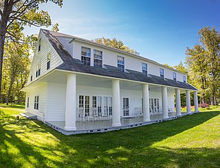
The Hebard–Ford Summer House is a private house located north of L'Anse, Michigan in Pequaming, Michigan. It is also known as the Ford Bungalow. The house was designated a Michigan State Historic Site in 1979 and listed on the National Register of Historic Places in 1982.

County Road 510 is a primary county road in Marquette County, Michigan, that connects Negaunee Township with the community of Big Bay. The road runs through rural forests as a paved and dirt road in northern Marquette County. It crosses the Dead River near the Hoist and McClure dams and runs for 26.103 miles (42.009 km) before terminating at an intersection with CR 550 south of Big Bay.
The Abbaye Peninsula is a 12.3-mile-long (19.8 km) peninsula located within Baraga County on the northern shore of the Upper Peninsula within the U.S. state of Michigan. It is bounded by Keweenaw Bay on the west and Huron Bay on the east.

Brooks-Scanlon Lumber Company was a lumber products company with large sawmills and significant land holdings in Minnesota, Florida, British Columbia, and Central Oregon. The company was formed in 1901 with its headquarters in Minneapolis, Minnesota. Beginning in 1915, its main lumber production facility was in Bend, Oregon. For many years, its Bend sawmill was one of the largest lumber producers in the world. In 1969, the company created Brooks Resources to broaden its business base beyond timber production. Brooks-Scanlon's Bend sawmill was closed in 1994. Today, Brooks Resources is the only vestige of the company that is still in business.
The Yosemite Lumber Company was an early 20th century Sugar Pine and White Pine logging operation in the Sierra Nevada. The company built the steepest logging incline ever, a 3,100 feet (940 m) route that tied the high-country timber tracts in Yosemite National Park to the low-lying Yosemite Valley Railroad running alongside the Merced River. From there, the logs went by rail to the company’s sawmill at Merced Falls, about fifty-four miles west of El Portal.

