| Percival Landing Park | |
|---|---|
 | |
 | |
| Type | Municipal (Olympia) |
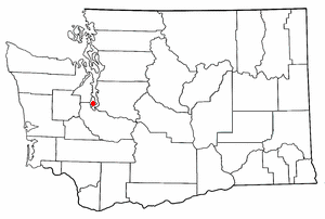
| Location | Olympia, Washington |
| Area | 3.38 acres (13,700 m2) |
| Status | Open all year |
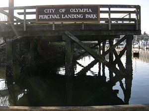
Percival Landing Park is a public park located in Olympia, Washington.
| Percival Landing Park | |
|---|---|
| | |
| | |
| Type | Municipal (Olympia) |
| Location | Olympia, Washington |
| Area | 3.38 acres (13,700 m2) |
| Status | Open all year |
Percival Landing Park is a public park located in Olympia, Washington.

Named after a former commercial steamship wharf, the park is a well-known maritime landmark in the Pacific Northwest. Built by Sam Percival in 1860, the wharf operated for several decades, and was torn down and replaced several times during that period. [1]
The first phase of Percival Landing Park was completed and opened in 1977, with the second phase opened in 1985, and the third phase in 1988. The former Unocal Tank Farm site was acquired by the City of Olympia in 1996, and is now an open lawn.

Today the park features picnic areas, public art, boat moorage and a playground. [2] The park features a 0.9-mile (1.4 km) boardwalk extends along the eastern shoreline of the West Bay of Budd Inlet from the Fourth Avenue Bridge to Thurston Avenue. The park features a carved Orca by Olympia artist Joe Tougas, who competed an identical work for Yashiro, Japan, Olympia's sister city. [3]
There are several events held annually at Percival Landing Park, including Harbor Days and "Sand in the City", as well as the Wooden Boat Festival.

Olympia is the capital of the U.S. state of Washington and the county seat and most populous city of Thurston County. It is 60 miles (100 km) southwest of the state's most populous city, Seattle, and is a cultural center of the southern Puget Sound region.
Raft Island is a private island and CDP located near the Pierce County community of Rosedale, Washington, United States. Gig Harbor, Washington is the nearest incorporated town, although unincorporated Artondale is much closer. The island features approximately 200 homes on 160 acres. All of these homes are served through the Gig Harbor post office.

Northlake is a neighborhood in Seattle, Washington, that consists of the southern part of Wallingford, below N 40th Street. It is so named for being on the northern shore of Lake Union. Landmarks include the Northlake Shipyard, Gas Works Park, the Wallingford Steps art installation, and Ivar's Salmon House. Circa 1900, the eastern part of Northlake was known as Latona, and the John Stanford International School building was formerly the Latona School. Nowadays, the name Latona is likely to refer to anywhere along Latona Ave. NE from Northlake north to NE 65th St. near Green Lake.


Purdy's Wharf is an office complex in Halifax, Nova Scotia, Canada. Built over the water at the edge of Halifax Harbour and resting on pilings, it consists of two office towers, and a smaller office structure called Purdy's Landing. The complex is located along the Halifax Waterfront Boardwalk.

The Capitol State Forest is a 110,000-acre (450 km2) state forest in Thurston and Grays Harbor counties of the U.S. state of Washington. It includes part of the unusual Mima Mounds geologic feature.

The Port of San Francisco is a semi-independent organization that oversees the port facilities at San Francisco, California, United States. It is run by a five-member commission, appointed by the Mayor and approved by the Board of Supervisors. The Port is responsible for managing the larger waterfront area that extends from the anchorage of the Golden Gate Bridge, along the Marina district, all the way around the north and east shores of the city of San Francisco including Fisherman's Wharf and the Embarcadero, and southward to the city line just beyond Candlestick Point. In 1968, the State of California, via the California State Lands Commission for the State-operated San Francisco Port Authority, transferred its responsibilities for the Harbor of San Francisco waterfront to the City and County of San Francisco / San Francisco Harbor Commission through the Burton Act AB2649. All eligible State port authority employees had the option to become employees of the City and County of San Francisco to maintain consistent operation of the Port of San Francisco.

The Berkeley Marina is the westernmost portion of the city of Berkeley, California, located west of the Eastshore Freeway at the foot of University Avenue on San Francisco Bay. Narrowly speaking, "Berkeley Marina" refers only to the city marina, but in common usage, it applies more generally to the surrounding area.

Long Wharf is a historic American pier in Boston, Massachusetts, built between 1710 and 1721. It once extended from State Street nearly a half-mile into Boston Harbor; today, the much-shortened wharf functions as a dock for passenger ferries and sightseeing boats.

Lockheed Shipbuilding and Construction Company, was a shipyard in Seattle, Washington with Yard 1 on Harbor Island and Yard 2 at what is now Jack Block Park at Seattle Terminal 5, both at the mouth of the West Waterway of Duwamish River. Yard 1 was founded in 1898 as the Puget Sound Bridge and Dredging Company, the company that built Harbor Island, and it was purchased by Lockheed in 1959. Yard 2 began operation in 1943 to build ships for the US Navy. The shipyard was permanently closed in 1988; Yard 2 was sold in 1989, and Yard 1 was sold in 1997, both to Port of Seattle.

The Chehalis Western Trail is a rail trail in Thurston County, Washington and is the longest shared-use path in the region. It occupies an abandoned railroad corridor that was once used by the historic Weyerhaeuser-owned Chehalis Western Railroad. The rail line was converted to a bicycle and walking trail and intersects with the 14.5-mile (23.3 km) Yelm-Rainier-Tenino Trail and the 4.7-mile (7.6 km) Karen Fraser Woodland Trail.

Quartermaster Harbor is a small harbor located in southern Puget Sound, in Vashon Island, Washington state.

Bigelow Neighborhood, also called the Bigelow Historic District, is a historic district located on the eastside of Olympia, Washington. It is located along Olympia Avenue, between East Bay Drive and Tullis Street.

Squaxin Park is a public park located in Olympia, Washington. Established in 1905, it was the city's first waterfront park, providing access to the Budd Inlet of Puget Sound. The park was formerly known as Priest Point Park, but was renamed in 2022 after the Olympia City Council unanimously voted to change it to honor the local Squaxin island Tribe.
Hands On Children's Museum is a children's museum in Olympia, Washington, USA. It was founded in 1987 and received over 150,000 visitors a year at its old location near the Washington State Capitol. After moving to its new, permanent home on Olympia's East Bay, at 414 Jefferson Street on Olympia's East Bay, visitorship grew to over 300,000 in its first year.
Moxlie Creek is a stream in Thurston County in the U.S. state of Washington. It is an Olympian creek originating from artesian springs in Watershed Park. It flows north into the East Bay of Budd Inlet. The creek is piped underground between East Bay and the headwaters, more than one third of its 1.8 mile length. For over 50 years the park groundwater was used to supply the city's drinking water, and waterworks remnants can be seen in the area.
Mud Bay is the southernmost reach of Puget Sound, at Eld Inlet just outside the city limits of Olympia, Washington. The name Eld Inlet was officially bestowed after a member of the U.S. Navy's Wilkes Expedition, but "Mud Bay" is a local, informal adoption.

Grass Lake Nature Park is a nature reserve in Olympia, Washington. The park has an area of 195.71 acres (79.20 ha).

Woodruff Park is an 2.38-acre (0.96 ha) urban park located in and administered by the city of Olympia, Washington. Amenities include a seasonal sprayground, picnic shelter, restrooms, volleyball court, tennis and pickleball courts, and a basketball half-court.
Burfoot Park is a public park located in Thurston County, Washington. Burfoot Park covers 50 acres of property with 1,100 feet of saltwater beach frontage on Budd Inlet of the Puget Sound.