Picture Puzzle

Last updated
Picture Puzzle
Picture Puzzle from Bishop Pass.jpg
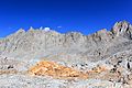
South aspect, from Bishop Pass
Highest point
Elevation 13,297 ft (4,053 m) [1]
Prominence 600 ft (180 m) [2]
Parent peak Cloudripper (13,525 ft) [3]
Isolation 1.12 mi (1.80 km) [3]
Coordinates 37°07′40″N118°32′20″W / 37.1279154°N 118.5388440°W / 37.1279154; -118.5388440 Coordinates: 37°07′40″N118°32′20″W / 37.1279154°N 118.5388440°W / 37.1279154; -118.5388440 [1]
Geography
Relief map of California.png
Red triangle with thick white border.svg
Picture Puzzle
Location in California
Usa edcp relief location map.png
Red triangle with thick white border.svg
Picture Puzzle
Picture Puzzle (the United States)
Location Inyo County, California, U.S.
Parent range Sierra Nevada
Palisades
Inconsolable Range [2]
Topo map USGS Mount Thompson
Geology
Type of rock granite
Climbing
First ascent 1937
Easiest route class 3 [3]

Picture Puzzle, also known as Picture Puzzle Peak, is a 13,297-foot-elevation (4,053 meter) mountain summit located one mile east of the crest of the Sierra Nevada mountain range in Inyo County of northern California, United States. [1] [4] It is situated in the Palisades area of the John Muir Wilderness, on land managed by Inyo National Forest. It is approximately 14.5 miles (23.3 km) west of the community of Big Pine, one mile north of Bishop Pass, 1.2 miles (1.9 km) north-northwest of Mount Agassiz, and 1.1 miles (1.8 km) south-southwest of parent Cloudripper. Picture Puzzle ranks as the 90th highest summit in California, [3] and the third highest peak of the Inconsolable Range. [2]

Contents

Climbing

Established climbing routes on Picture Puzzle: [5]

The first ascent of the summit was made June 15, 1937, by Norman Clyde, who is credited with 130 first ascents, most of which were in the Sierra Nevada. [6] [7]

Climate

According to the Köppen climate classification system, Picture Puzzle is located in an alpine climate zone. [8] Most weather fronts originate in the Pacific Ocean, and travel east toward the Sierra Nevada mountains. As fronts approach, they are forced upward by the peaks, causing them to drop their moisture in the form of rain or snowfall onto the range (orographic lift). Precipitation runoff from this mountain drains east into headwaters of North Fork Big Pine Creek, and west into headwaters of South Fork Bishop Creek.

See also

Related Research Articles

Mount Goode (California)

Mount Goode is a 13,085-foot-elevation mountain summit located on the crest of the Sierra Nevada mountain range in California, United States. It is situated on the shared boundary of Kings Canyon National Park with John Muir Wilderness, and along the common border of Fresno County with Inyo County. It is also approximately one mile west-northwest of Bishop Pass, one mile east-southeast of Mount Johnson, 1.23 miles (1.98 km) south of Hurd Peak, and 16 miles (26 km) west of the community of Big Pine.

Mount Dade

Mount Dade is a 13,600-foot-elevation mountain summit located on the crest of the Sierra Nevada mountain range in northern California, United States. It is situated in the John Muir Wilderness on the shared boundary of Sierra National Forest with Inyo National Forest, and along the common border of Fresno County with Inyo County. It is one mile west of Dade Lake, and approximately 22 miles (35 km) west of the community of Bishop. Nearby neighbors include Mount Abbot, 0.4 mile to the northwest, and Bear Creek Spire 1.2 mile to the southeast. The USGS probably named this peak during a 1907–09 survey, and the first ascent was made August 19, 1911, by Liston and McKeen, of Fresno.

Mount Thompson (California)

Mount Thompson is a 13,494-foot-elevation mountain summit located on the crest of the Sierra Nevada mountain range in California, United States. It is situated on the shared boundary of Kings Canyon National Park with John Muir Wilderness, and along the common border of Fresno County with Inyo County. It is also 18 miles (29 km) west of the community of Big Pine, one mile northwest of Mount Gilbert, and three miles east of Mount Fiske, which is the nearest higher neighbor. Mount Thompson ranks as the 62nd-highest summit in California. This mountain's name commemorates Almon Harris Thompson (1839–1906). The first ascent of the peak was made by Clarence H. Rhudy and H. F. Katzenbach in the summer of 1909.

Mount Fiske

Mount Fiske is a 13,503-foot-elevation mountain summit located near the crest of the Sierra Nevada mountain range, in Fresno County of northern California, United States. It is situated in northern Kings Canyon National Park, 23 miles (37 km) west of the community of Big Pine, 0.83 miles (1.34 km) east of Mount Huxley, and two miles south of Mount Darwin, which is the nearest higher neighbor. Mount Fiske ranks as the 60th highest summit in California.

Black Giant

Black Giant is a 13,330-foot-elevation mountain summit located near the crest of the Sierra Nevada mountain range, in Fresno County of northern California, United States. Black Giant ranks as the 86th highest summit in California. It is situated in northern Kings Canyon National Park, 21 miles (34 km) west-southwest of the community of Big Pine, 3.6 miles (5.8 km) southwest of Mount Thompson, and 2.6 miles (4.2 km) south-southeast of Mount Fiske, which is the nearest higher neighbor. Topographic relief is significant as it rises 4,000 feet (1,220 meters) above LeConte Canyon in approximately two miles. Muir Pass is 1.5 miles (2.4 km) to the northwest, and the approach to this remote peak is made via the John Muir Trail.

Langille Peak

Langille Peak is a 12,018-foot-elevation mountain summit located near the crest of the Sierra Nevada mountain range, in Fresno County of northern California, United States. It is situated in northern Kings Canyon National Park, 19 miles (31 km) west-southwest of the community of Big Pine, 3 miles (4.8 km) south of Mount Thompson, 2.8 miles (4.5 km) southwest of Mount Goode, and 2.1 miles (3.4 km) east of Black Giant. Topographic relief is significant as the east aspect rises 3,100 feet (945 meters) above LeConte Canyon in less than one mile. The approach to this remote peak is made via the John Muir Trail.

Mount Warlow

Mount Warlow is a 13,206-foot-elevation mountain summit located 1.5 miles (2.4 km) west of the crest of the Sierra Nevada mountain range, in Fresno County of northern California, United States. It is situated on the Goddard Divide in northern Kings Canyon National Park, 1.2 miles (1.9 km) north of Muir Pass, 0.69 miles (1.11 km) southeast of Mount Huxley, and 0.68 miles (1.09 km) southwest of Mount Fiske, which is the nearest higher neighbor. Mount Warlow ranks as the 108th highest summit in California. The approach to this remote peak is made via the John Muir Trail.

Mount Gayley

Mount Gayley is a 13,510-foot-elevation mountain summit located one mile east of the crest of the Sierra Nevada mountain range in Inyo County, California, United States. It is situated in the Palisades area of the John Muir Wilderness, on land managed by Inyo National Forest. It is approximately 13 miles (21 km) west-southwest of the community of Big Pine, 0.67 miles (1.08 km) southwest of Temple Crag, and 0.5 miles (0.80 km) north-northeast of parent Mount Sill. Mount Gayley ranks as the 59th highest summit in California.

Cloudripper

Cloudripper is a 13,525-foot-elevation mountain summit located two miles east of the crest of the Sierra Nevada mountain range in Inyo County of northern California, United States. It is situated in the Palisades area of the John Muir Wilderness, on land managed by Inyo National Forest. It is approximately 14 miles (23 km) west of the community of Big Pine, 1.1 miles (1.8 km) north-northeast of Picture Puzzle, and 2.1 miles (3.4 km) south of parent Mount Agassiz. Cloudripper ranks as the 58th highest summit in California, and the highest point of the Inconsolable Range.

Red and White Mountain

Red and White Mountain is a remote 12,816-foot-elevation mountain summit located on the crest of the Sierra Nevada mountain range in northern California, United States. It is situated in the John Muir Wilderness on the shared boundary of Sierra National Forest with Inyo National Forest, and along the common border of Fresno County with Mono County. It is eight miles northeast of Lake Thomas A Edison, and approximately 13 miles (21 km) southeast of the community of Mammoth Lakes. The nearest higher neighbor is Red Slate Mountain, 2 miles (3.2 km) to the north-northwest.

Picture Peak

Picture Peak is a 13,140-foot-elevation mountain summit located one mile east of the crest of the Sierra Nevada mountain range in Inyo County of northern California, United States. It is situated in the John Muir Wilderness, on land managed by Inyo National Forest. It is approximately 21 miles (34 km) west of the community of Big Pine, and 0.65 miles (1.05 km) east of parent Mount Haeckel. Topographic relief is significant as the north aspect rises over 2,000 feet (610 meters) above Hungry Packer Lake in approximately one-half mile. The first ascent of the summit was made July 1967, by Gary Colliver and Steve Thompson via the northeast face. This mountain's name has not been officially adopted by the U.S. Board on Geographic Names.

The Hermit (California mountain)

The Hermit is a 12,328-foot-elevation mountain summit located west of the crest of the Sierra Nevada mountain range, in Fresno County of northern California, United States. It is situated in northern Kings Canyon National Park, 2.5 miles (4.0 km) east of Emerald Peak, and 2.5 miles (4.0 km) west of Mount Darwin. Topographic relief is significant as the north aspect rises 2,500 feet (762 meters) above Evolution Valley in less than one mile. The John Muir Trail passes to the east and north of this landmark, providing an approach. This geographical feature was named by Sierra Club explorer Theodore Solomons in 1895 as he wrote: "The traveler will be greatly attracted by a very sharp peak or butte that rises on the south wall. From its isolated position as viewed from the valley we called it the Hermit."

Mount Powell (California)

Mount Powell is a 13,364-foot-elevation mountain summit located on the crest of the Sierra Nevada mountain range in California, United States. It is situated on the shared boundary of Kings Canyon National Park with John Muir Wilderness, and along the common border of Fresno County with Inyo County. It is also 19 miles (31 km) west of the community of Big Pine, and 1.17 miles (1.88 km) west of Mount Thompson, which is the nearest higher neighbor. Mount Powell ranks as the 81st highest peak in California, and the 10th highest of the Evolution Region of the Sierra Nevada. The west summit is unofficially known as "Point John." Two other peaks on the mountain are informally called "Point Wesley" (13,356 ft) in the middle, and "Point Powell" (13,360+ ft) one-half mile to the east.

Mount Carillon

Mount Carillon is a 13,553-foot-elevation (4,131 meter) mountain summit located on the crest of the Sierra Nevada mountain range in California. It is situated on the common border of Tulare County with Inyo County, as well as the shared boundary of Sequoia National Park and John Muir Wilderness. It is set above the south shore of Tulainyo Lake, 12.5 miles (20.1 km) west of the community of Lone Pine, 1.25 mile (2.0 km) northeast of Mount Whitney, and 0.7 mile (1.1 km) east-northeast of Mount Russell, the nearest higher neighbor. Topographic relief is significant as it rises approximately 5,180 feet (1,580 meters) above Whitney Portal in approximately two miles. Carillon has subpeaks, unofficially called "The Cleaver", 0.4 mile to the northeast, and "Impala", on the southeast ridge.

Mount Lamarck

Mount Lamarck is a 13,417-foot-elevation mountain summit located on the crest of the Sierra Nevada mountain range in northern California, United States. It is situated on the shared boundary of Kings Canyon National Park with John Muir Wilderness, and along the common border of Fresno County with Inyo County. It is 20 miles (32 km) southwest of the community of Bishop, and 1.9 miles (3.1 km) north of Mount Darwin. Subsidiary peak Mount Lamarck North ranks as the 67th highest summit in California, and the sixth highest in the Evolution Region. Topographic relief is significant as the east aspect rises 4,290 feet (1,307 meters) above Lake Sabrina in three miles, and the west aspect rises 3,600 feet (1,097 meters) above Evolution Valley in three miles.

Goodale Mountain

Goodale Mountain is a 12,772-foot-elevation (3,893 meter) mountain summit located one mile east of the crest of the Sierra Nevada mountain range, in Inyo County of northern California. It is situated less than two miles southeast of Taboose Pass in the John Muir Wilderness, on land managed by Inyo National Forest. It is also 16.5 miles (26.6 km) northwest of the community of Independence, and one mile northeast of Striped Mountain, the nearest higher neighbor. Topographic relief is significant as the east aspect rises 7,200 feet (2,200 meters) above Owens Valley in 3.5 miles. It ranks as the 218th highest peak in California.

Whaleback (California)

Whaleback is a remote 11,717-foot-elevation three-mile-long ridge located in the Sierra Nevada mountain range, in Tulare County of northern California. It is situated in Kings Canyon National Park, extending north from the Great Western Divide. This geographical feature has significant topographic relief as it rises 2,900 feet (884 meters) above Shortys Cabin in Cloud Canyon in approximately one mile. Whaleback ranks as the 488th highest peak in California. The first ascent of the summit was made August 5, 1936, by May Pridham and Adele van Loben Sels.

Mount McDuffie

Mount McDuffie is a 13,291-foot-elevation mountain summit located west of the crest of the Sierra Nevada mountain range, in Fresno County of northern California, United States. This peak is situated in Kings Canyon National Park, 1.9 miles (3.1 km) northwest of The Citadel, and two miles south of Black Giant, which is the nearest higher neighbor. McDuffie ranks as the 93rd highest summit in California, and the second-highest point on Black Divide. Topographic relief is significant as it rises nearly 4,900 feet (1,493 meters) above Middle Fork Kings River in approximately 2.5 miles. An approach to this remote peak is made possible via the John Muir Trail.

Mount Baldwin (California)

Mount Baldwin is a 12,614-foot-elevation mountain summit located in the Sierra Nevada mountain range in Mono County of northern California, United States. It is situated in the John Muir Wilderness on land managed by Inyo National Forest. It is four miles north of Red and White Mountain, and approximately 10.5 miles (16.9 km) southeast of the community of Mammoth Lakes. The nearest higher neighbor is Red Slate Mountain, 2 miles (3.2 km) to the south-southwest. Baldwin ranks as the 257th highest summit in California. Topographic relief is significant as the east aspect rises 3,775 feet (1,150 meters) above McGee Canyon in 1.5 mile. The first ascent of the summit was made July 2, 1928, by Norman Clyde, who is credited with 130 first ascents, most of which were in the Sierra Nevada.

Mount Gilbert (California)

Mount Gilbert is a 13,106-foot-elevation mountain summit located on the crest of the Sierra Nevada mountain range in California, United States. It is situated on the shared boundary of Kings Canyon National Park with John Muir Wilderness, and along the common border of Fresno County with Inyo County. It is also 18 miles (29 km) west of the community of Big Pine, 0.8 mile northwest of Mount Johnson, and one mile southeast of Mount Thompson, which is the nearest higher neighbor. Mount Gilbert ranks as the 127th-highest summit in California. Topographic relief is significant as the south aspect rises 3,900 feet (1,190 meters) above LeConte Canyon in less than two miles, and the north aspect rises 3,340 feet above South Lake in 2.5 miles.

References

  1. 1 2 3 "Picture Puzzle". Geographic Names Information System . United States Geological Survey . Retrieved 2021-04-20.
  2. 1 2 3 "Picture Puzzle Peak, California". Peakbagger.com. Retrieved 2021-04-20.
  3. 1 2 3 4 "Picture Puzzle - 13,300' CA". listsofjohn.com. Retrieved 2021-04-20.
  4. Steve Roper, The Climber's Guide to the High Sierra, 1976, Sierra Club Books, ISBN   9780871561473, page 195.
  5. R. J. Secor, The High Sierra Peaks, Passes, Trails, 2009, Third Edition, Mountaineers Books, ISBN   9781594857386
  6. Norman Clyde - Mountaineer, Owensvalleyhistory.com
  7. R. J. Secor, The High Sierra Peaks, Passes, Trails, 2009, Third Edition, Mountaineers Books, ISBN   9781594857386, page 203.
  8. Peel, M. C.; Finlayson, B. L.; McMahon, T. A. (2007). "Updated world map of the Köppen−Geiger climate classification". Hydrol. Earth Syst. Sci. 11. ISSN   1027-5606.