Pine Bluffs, Wyoming

Last updated

Pine Bluffs, Wyoming
A curious old building that straddles the Nebraska-Wyoming border in Pine Bluffs, a small farming community that's 90 percent in Laramie County, Wyoming LCCN2015632941.tif
On the Wyoming-Nebraska border
Nickname: 
Title Town
Laramie County Wyoming Incorporated and Unincorporated areas Pine Bluffs Highlighted 5661435.svg
Location of Pine Bluffs in Laramie County, Wyoming.
Usa edcp location map.svg
Red pog.svg
Pine Bluffs, Wyoming
Location in the United States
Coordinates: 41°10′46″N104°4′7″W / 41.17944°N 104.06861°W / 41.17944; -104.06861
Country United States
State Wyoming
County Laramie
Area
[1]
  Total3.22 sq mi (8.35 km2)
  Land3.22 sq mi (8.35 km2)
  Water0.00 sq mi (0.00 km2)
Elevation
5,049 ft (1,539 m)
Population
 (2010) [2]
  Total1,129
  Estimate 
(2019) [3]
1,159
  Density359.49/sq mi (138.79/km2)
Time zone UTC-7 (Mountain (MST))
  Summer (DST) UTC-6 (MDT)
ZIP code
82082
Area code 307
FIPS code 56-61435 [4]
GNIS feature ID1609139 [5]
Website pinebluffswy.gov

Pine Bluffs is a town in eastern Laramie County, Wyoming, United States. It is located on the county's border with Nebraska. Pine Bluffs is part of the Cheyenne, Wyoming, Metropolitan Statistical Area. The population was 1,129 at the 2010 census. [6] It was first known as Rock Ranch, but the name was changed by railroad officials for the pines on the nearby bluffs.

Contents

History

Pine Bluffs, 1868 Pine Bluffs, Wyoming (1868).jpg
Pine Bluffs, 1868

The first gas station in Pine Bluffs was built by politician William Henry Harrison and A. E. Carlstrum. [7] On October 17, 1956, the Wyoming Public Service Commission authorized William Henry Harrison III to build and operate a community television system in the town. [8]

In July 2016, Pine Bluffs was battered by a severe hailstorm, causing widespread damage. The Wyoming National Guard was called in to deal with the damage. [9]

Geography

According to the United States Census Bureau, the town has a total area of 3.22 square miles (8.34 km2), all land. [10]

Pine Bluffs experiences a semi-arid climate (Köppen climate classification BSk ).

Climate data for Pine Bluffs
MonthJanFebMarAprMayJunJulAugSepOctNovDecYear
Record high °F (°C)70
(21)
75
(24)
85
(29)
91
(33)
97
(36)
105
(41)
109
(43)
104
(40)
101
(38)
91
(33)
82
(28)
74
(23)
109
(43)
Mean daily maximum °F (°C)39
(4)
43
(6)
49
(9)
58
(14)
68
(20)
80
(27)
87
(31)
85
(29)
75
(24)
63
(17)
48
(9)
40
(4)
61
(16)
Mean daily minimum °F (°C)12
(−11)
16
(−9)
23
(−5)
30
(−1)
40
(4)
49
(9)
54
(12)
53
(12)
43
(6)
32
(0)
20
(−7)
13
(−11)
32
(0)
Record low °F (°C)−34
(−37)
−31
(−35)
−21
(−29)
−3
(−19)
18
(−8)
26
(−3)
32
(0)
34
(1)
6
(−14)
−4
(−20)
−17
(−27)
−38
(−39)
−38
(−39)
Average precipitation inches (mm)0.44
(11)
0.28
(7.1)
1.12
(28)
1.59
(40)
2.44
(62)
2.26
(57)
2.51
(64)
2.05
(52)
1.28
(33)
0.67
(17)
0.55
(14)
0.40
(10)
15.59
(396)
Source: Weather.com [11]

Demographics

Historical population
CensusPop.Note
1910 246
1920 618151.2%
1930 6708.4%
1940 77115.1%
1950 8469.7%
1960 1,12132.5%
1970 937−16.4%
1980 1,07714.9%
1990 1,054−2.1%
2000 1,1539.4%
2010 1,129−2.1%
2019 (est.)1,159 [3] 2.7%
U.S. Decennial Census [12]

2010 census

As of the census [2] of 2010, there were 1,129 people, 476 households, and 314 families residing in the town. The population density was 350.6 inhabitants per square mile (135.4/km2). There were 532 housing units at an average density of 165.2 per square mile (63.8/km2). The racial makeup of the town was 94.2% White, 0.2% African American, 0.9% Native American, 0.4% Asian, 2.3% from other races, and 2.0% from two or more races. Hispanic or Latino of any race were 11.1% of the population.

There were 476 households, of which 31.5% had children under the age of 18 living with them, 52.9% were married couples living together, 8.0% had a female householder with no husband present, 5.0% had a male householder with no wife present, and 34.0% were non-families. 30.0% of all households were made up of individuals, and 11.6% had someone living alone who was 65 years of age or older. The average household size was 2.35 and the average family size was 2.92.

The median age in the town was 42.6 years. 25.2% of residents were under the age of 18; 6.2% were between the ages of 18 and 24; 21.7% were from 25 to 44; 28.7% were from 45 to 64; and 18.2% were 65 years of age or older. The gender makeup of the town was 51.0% male and 49.0% female.

2000 census

As of the census [4] of 2000, there were 1,153 people, 482 households, and 332 families residing in the town. The population density was 357.4 people per square mile (137.8/km2). There were 517 housing units at an average density of 160.3 per square mile (61.8/km2). The racial makeup of the town was 95.92% White, 0.17% African American, 0.69% Native American, 0.17% Asian, 1.82% from other races, and 1.21% from two or more races. Hispanic or Latino of any race were 6.85% of the population.

There were 482 households, out of which 30.1% had children under the age of 18 living with them, 55.2% were married couples living together, 9.8% had a female householder with no husband present, and 31.1% were non-families. 28.2% of all households were made up of individuals, and 14.9% had someone living alone who was 65 years of age or older. The average household size was 2.38 and the average family size was 2.90.

In the town, the population was spread out, with 27.3% under the age of 18, 5.6% from 18 to 24, 23.2% from 25 to 44, 25.0% from 45 to 64, and 18.9% who were 65 years of age or older. The median age was 41 years. For every 100 females, there were 95.1 males. For every 100 females age 18 and over, there were 87.9 males.

The median income for a household in the town was $33,152, and the median income for a family was $40,417. Males had a median income of $30,078 versus $20,500 for females. The per capita income for the town was $15,525. About 7.3% of families and 10.1% of the population were below the poverty line, including 15.2% of those under age 18 and 8.3% of those age 65 or over.

Education

Public education in the town of Pine Bluffs is provided by Laramie County School District #2. Schools serving the town include Pine Bluffs Elementary School (grades K–6) and Pine Bluffs Junior/Senior High School (grades 7–12).

Pine Bluffs has a public library, a branch of the Laramie County Library System. [13]

Notable people

Related Research Articles

<span class="mw-page-title-main">Washakie County, Wyoming</span> County in Wyoming, United States

Washakie County is a county in the U.S. state of Wyoming. As of the 2020 United States Census, the population was 7,685. Its county seat is Worland.

<span class="mw-page-title-main">Platte County, Wyoming</span> County in Wyoming, United States

Platte County is a county located in the U.S. state of Wyoming. As of the 2020 United States Census, the population was 8,605. Its county seat is Wheatland.

<span class="mw-page-title-main">Park County, Wyoming</span> County in Wyoming, United States

Park County is a county in the U.S. state of Wyoming. As of the 2020 United States Census, the population was 29,624. The county seat is Cody.

<span class="mw-page-title-main">Laramie County, Wyoming</span> County in Wyoming, United States

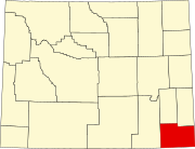
Laramie County is a county located at the southeast corner of the state of Wyoming. As of the 2020 United States Census, the population was 100,512 or 17.4% of the state's total 2020 population, making it the most populous county in Wyoming, but the least populous county in the United States to be the most populous in its state.

<span class="mw-page-title-main">Goshen County, Wyoming</span> County in Wyoming, United States

Goshen County is a county in the U.S. state of Wyoming. As of the 2020 United States Census, the population was 12,498. Its county seat is Torrington. The eastern boundary of the County borders the Nebraska state line.

<span class="mw-page-title-main">Crook County, Wyoming</span> County in Wyoming, United States

Crook County is a county in the northeastern corner of the U.S. state of Wyoming. As of the 2020 United States Census, the population was 7,181, making it the third-least populous county in Wyoming. Its county seat and largest city is Sundance. The county is located at the northwestern extreme of the Black Hills, which are its defining geographical feature.

<span class="mw-page-title-main">Converse County, Wyoming</span> County in Wyoming, United States

Converse County is a county located in the U.S. state of Wyoming. As of the 2020 United States Census, the population was 13,751. Its county seat is Douglas.

<span class="mw-page-title-main">Albany County, Wyoming</span> County in Wyoming, United States

Albany County is a county in the U.S. state of Wyoming. As of the 2020 United States Census, the population was 37,066. Its county seat is Laramie, the site of the University of Wyoming. Its south border lies on the northern Colorado state line.

<span class="mw-page-title-main">White Hall, Arkansas</span> City in Arkansas, United States

White Hall is a city in Washington Township, located in Jefferson County, Arkansas, United States. With a population of 5,526 in the 2010 census, it is included in the Pine Bluff Metropolitan Statistical Area and the greater Little Rock-North Little Rock-Pine Bluff Combined Statistical Area. White Hall is home to the Pine Bluff Arsenal.

<span class="mw-page-title-main">Dunbar, Nebraska</span> Village in Nebraska, United States

Dunbar is a village in Otoe County, Nebraska, United States. The population was 165 at the 2020 census.

<span class="mw-page-title-main">Pineville, West Virginia</span> Town in West Virginia, United States

Pineville is a town in and the county seat of Wyoming County, West Virginia, United States, situated along the Guyandotte River. The population was 648 at the 2020 census.

<span class="mw-page-title-main">Centennial, Wyoming</span> CDP in Wyoming, United States

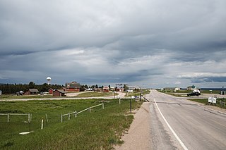
Centennial is a small mountain-town in Albany County, Wyoming, United States. It serves a fairly large surrounding landscape, along with a few ranches, located along a gently sloping hillside traversed by a highway. Because it has been, since 1980 or later, included in a census-designated place (CDP), bearing the town's name, specific demographics characterizing the town itself are not available.

<span class="mw-page-title-main">Esterbrook, Wyoming</span> CDP in Wyoming, United States

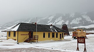
Esterbrook is a village, and the locus of a same-named census-designated place (CDP), in Converse County, Wyoming, United States in the Medicine Bow National Forest. The population was 52 at the 2010 census.

<span class="mw-page-title-main">Pine Haven, Wyoming</span> Town in Wyoming, United States

Pine Haven is a town in Crook County, Wyoming, United States. The population was 493 at the 2020 census.

<span class="mw-page-title-main">Fort Laramie, Wyoming</span> Town in Wyoming, United States

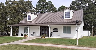
Fort Laramie is a town in Goshen County, Wyoming, United States. The population was 206 at the 2020 census. The town is named after historic Fort Laramie, an important stop on the Oregon, California and Mormon trails, as well as a staging point for various military excursions and treaty signings. The old fort was located south of town across the North Platte River, at the mouth of the Laramie River.

<span class="mw-page-title-main">Albin, Wyoming</span> Town in Laramie County, Wyoming, United States

Albin is a town in Laramie County, Wyoming, United States. It is part of the Cheyenne Metropolitan Statistical Area. The population was 169 at the 2020 census.

<span class="mw-page-title-main">Burns, Wyoming</span> Town in Laramie County, Wyoming, United States

Burns is a town in Laramie County, Wyoming, United States. It is part of the Cheyenne, Wyoming Metropolitan Statistical Area. The population was 301 at the 2010 census.

<span class="mw-page-title-main">Ranchettes, Wyoming</span> Census-designated place in Wyoming, United States

Ranchettes is a census-designated place (CDP) in Laramie County, Wyoming, United States. It is part of the Cheyenne, Wyoming Metropolitan Statistical Area. The population was 5,798 at the 2010 census.

<span class="mw-page-title-main">Lyman, Wyoming</span> Town in Wyoming, United States

Lyman is a town in Uinta County, Wyoming, United States. The population was 2,115 at the 2010 census.

<span class="mw-page-title-main">Cross Plains (town), Wisconsin</span>

Cross Plains is a town in Dane County, Wisconsin, United States. The population was 1,419 at the 2000 census. The Village of Cross Plains is located partially within the town. The unincorporated community of Pine Bluff is located in the town.

References

  1. "2019 U.S. Gazetteer Files". Census.gov . United States Census Bureau. Retrieved August 7, 2020.
  2. 1 2 "U.S. Census website". United States Census Bureau . Retrieved December 14, 2012.
  3. 1 2 "Population and Housing Unit Estimates". United States Census Bureau. May 24, 2020. Retrieved May 27, 2020.
  4. 1 2 "U.S. Census website". United States Census Bureau . Retrieved January 31, 2008.
  5. "US Board on Geographic Names". United States Geological Survey. October 25, 2007. Retrieved January 31, 2008.
  6. "Profile of General Population and Housing Characteristics: 2010 Demographic Profile Data (DP-1): Pine Bluffs town, Wyoming". United States Census Bureau . Retrieved April 2, 2012.
  7. "William 'Bill' Henry Harrison". Casper Star-Tribune. December 29, 1991. p. 14. Archived from the original on May 7, 2020 via Newspapers.com.
  8. "Television System for Pine Bluffs Authorized". Casper Morning Star. October 19, 1956. p. 17. Archived from the original on May 12, 2020 via Newspapers.com.
  9. Becky Orr. "Golf ball-sized hail pounds Pine Bluffs". Wyoming Tribune Eagle . Retrieved January 9, 2018.
  10. "US Gazetteer files 2010". United States Census Bureau. Archived from the original on January 12, 2012. Retrieved December 14, 2012.
  11. "Pine Bluffs, WY Monthly Weather Forecast". Weather.com. Retrieved January 9, 2018.
  12. "Census of Population and Housing". Census.gov. Retrieved June 4, 2015.
  13. "Wyoming Public Libraries". PublicLibraries.com. Retrieved June 13, 2019.