Pine Creek Rail Trail

Last updated

Pine Creek Rail Trail
Rail trail at Blackwell.jpg
Rail trail passing through Blackwell
Pine Creek Rail Trail
Length65 miles
Location Lycoming and Tioga Counties, Pennsylvania, U.S.
Established1996, 2007 to Wellsboro, 2012 in Jersey Shore
DesignationPA Bike Route G.svg BicyclePA Route G
Trailheads Route 287, Wellsboro, PA 41°47′18″N77°18′29″W / 41.788221°N 77.308019°W / 41.788221; -77.308019 (Northern end, PCRT) Railroad Street, Jersey Shore, PA 41°12′00″N77°17′13″W / 41.199888°N 77.287065°W / 41.199888; -77.287065 (Southern end, PCRT)
UseHiking and Cycling
Grade Gentle (former railroad)
DifficultyEasy
SeasonHiking and cycling in spring, summer, and fall; cross-country skiing in winter
Sights Pine Creek Gorge, hawks, Canada geese, and occasionally bald eagles, American black bears and white-tailed deer
Hazards Severe Weather, Poison ivy, Bears
Surface Crushed limestone

The Pine Creek Rail Trail is the only rail trail in the Appalachian Mountains of north-central Pennsylvania.

Contents

The trail begins just north of Wellsboro, runs south through Pine Creek Gorge (also known as the Grand Canyon of Pennsylvania) and ends at Jersey Shore. A article in USA Today from 2001 named the 65-mile-long (105 km) trail as one of the "10 great places to take a bike tour" in the world. [1] [2]

Route

The rail trail uses a former New York Central Railroad bridge to cross over Little Pine Creek in Waterville Pine Creek Rail Trail Bridge in Waterville.JPG
The rail trail uses a former New York Central Railroad bridge to cross over Little Pine Creek in Waterville

The Pine Creek Rail Trail spans approximately 65 miles (105 km) from end to end, following a primarily north–south orientation. It is located entirely within Tioga and Lycoming Counties. Additionally, a portion of the trail is designated as BicyclePA Route G. [3]

The trail's northern terminus is near the intersection of U.S. Route 6 and Pennsylvania Route 287, about 3 miles (4.8 km) north of Wellsboro. Parking for the northern terminus is located at the southernmost end of Butler Road. The trail parallels Route 6 in a southwesterly direction for about 6 miles (9.7 km) until it reaches the village of Ansonia. South of Ansonia, the trail parallels Pine Creek as it goes south along the floor of Pine Creek Gorge. It passes through Leonard Harrison State Park and the Tioga State Forest. Approximately 17 miles (27 km) south of Ansonia, the trail passes through the village of Blackwell. [2] The section between Ansonia and Blackwell is very remote, and much of the trail is inaccessible by road.

South of Blackwell, the trail enters Lycoming County and the Tiadaghton State Forest. It parallels Pennsylvania Route 414 for about 25 miles (40 km). Pennsylvania Route 414 ends near the unincorporated village of Waterville. South of Waterville, the trail parallels Pennsylvania Route 44 for approximately 17 miles (27 km) until the trail reaches its southern terminus in Jersey Shore. (Parking at Railroad St. and Humes St.) Between Blackwell and Jersey Shore, the trail crosses the highway and Pine Creek several times, and it is almost always within sight of both the road and the creek.

Pine Creek Rail Trail near Blackwell (2005) PineCreekTrail2005.JPG
Pine Creek Rail Trail near Blackwell (2005)

Boroughs, villages, and attractions located along or near the trail (from north to south):

History

Pine Creek and the rail trail north of Waterville in Cummings Township in Lycoming County Pine Creek Rail Trail 2.JPG
Pine Creek and the rail trail north of Waterville in Cummings Township in Lycoming County

The Native American Pine Creek Path followed Pine Creek from Jersey Shore to Ansonia and beyond. The earliest industry in the region was logging. In the years between 1820 and 1883, trees were floated down the creek to sawmills in Jersey Shore and Williamsport. In 1883, the Jersey Shore, Pine Creek and Buffalo Railway opened. Sawmills were constructed in several communities along the creek, and finished products were carried out by train. Coal mining was another important industry, and coal was also shipped along the railroad.

After a series of reorganizations, the railroad along Pine Creek became a part of the New York Central Railroad and eventually Conrail. Freight and passenger service continued until 1988, when Conrail ended rail service. The tracks were removed, and the first section of the Pine Creek Rail Trail opened in 1996. [4] The trail opened in stages with the most recent section (from Ansonia to just north of Wellsboro) being completed in 2007. [5] The trail is operated by the Pennsylvania Department of Conservation and Natural Resources.

In 2001, an article in the USA Today newspaper named the Pine Creek Rail Trail one of "10 great places to take a bike tour" in the world. It was one of only five places in the continental United States on the list, which was compiled by Patricia Vance, author of bicycle touring guides. The article cited the "Grand Canyon of Pennsylvania" as "idyllic in fall" and mentioned the "gorge with views of the cliffs and mixed hardwood forest". [1]

During the Great Depression, the Civilian Conservation Corps built numerous roads, bridges, and trails through the area. [6] Evidence of their work is still visible and is commemorated with a sign near the Darling Run trail access area.

Activities

Hiker on the Pine Creek Rail Trail just north of Blackwell in Tioga County, Pennsylvania. Pine Creek Rail Trail.JPG
Hiker on the Pine Creek Rail Trail just north of Blackwell in Tioga County, Pennsylvania.

Due to the trail being originally constructed as a rail bed it is relatively flat with only gentle grades. It is topped with crushed limestone. Bicycling, hiking and in the winter cross-country skiing are the only permitted activities on the trail. Without a written permit from the Pennsylvania Department of Conservation and Natural Resources, motorized vehicles are strictly forbidden from using the trail. This ban includes motorcycles, snowmobiles and all-terrain vehicles. Between Ansonia and Tiadaghton, horseback riding is permitted on the trail. There are camping sites along the trail, but require permits be obtained in advance from the Pennsylvania Department of Conservation and Natural Resources. Additional amenities along the trail include composting toilets and water pumps.

Future expansion

The final section of the trail opened in 2007, and there are no immediate plans to expand the trail at this time. [5] Several groups have proposed expanding the trail into the borough of Wellsboro or building a trail along the West Branch Susquehanna River between Jersey Shore and Williamsport. The next phase of the Bald Eagle Valley Trail, in neighboring Clinton County, will link to the southern terminus in Jersey Shore. [7]

See also

Related Research Articles

<span class="mw-page-title-main">Cummings Township, Lycoming County, Pennsylvania</span> Township in Pennsylvania, United States

Cummings Township is a township in Lycoming County, Pennsylvania, United States. The population was 264 at the 2020 census, down from 273 in 2010. It is part of the Williamsport, Pennsylvania Metropolitan Statistical Area. Cummings Township is home to Little Pine State Park and Upper Pine Bottom State Park.

<span class="mw-page-title-main">Delmar Township, Tioga County, Pennsylvania</span> Township in Pennsylvania, United States

Delmar Township is a township in Tioga County, Pennsylvania, United States. The population was 2,796 at the 2020 census.

<span class="mw-page-title-main">Shippen Township, Tioga County, Pennsylvania</span> Township in Pennsylvania, United States

Shippen Township is a township in Tioga County, Pennsylvania, United States. The population was 500 at the 2020 census. Two Pennsylvania state parks, Colton Point and Leonard Harrison are in Shippen Township at the Pennsylvania Grand Canyon. The Grand Canyon Airport is also located on Pennsylvania Route 362 in Shippen Township.

<span class="mw-page-title-main">Mid State Trail (Pennsylvania)</span>

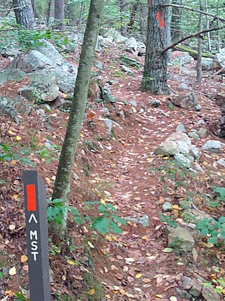
The Mid State Trail (MST) is a 327-mile (526 km) linear hiking trail located in the Appalachian Mountains and Allegheny Plateau of central Pennsylvania, United States. It is the longest hiking trail in Pennsylvania, and one of just three to traverse the state from one border to another. A portion of the Mid State Trail is also part of the Great Eastern Trail.

<span class="mw-page-title-main">Pine Creek (Pennsylvania)</span> Creek in Pennsylvania, United States

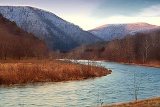
Pine Creek is a tributary of the West Branch Susquehanna River in Potter, Tioga, Lycoming, and Clinton counties in Pennsylvania. The creek is 87.2 miles (140.3 km) long. Within Tioga County, 23.25 miles (37.42 km) of Pine Creek are designated as a Pennsylvania Scenic River.

<span class="mw-page-title-main">Tiadaghton State Forest</span> State forest in Pennsylvania, United States

Tiadaghton State Forest is a Pennsylvania State Forest in the Pennsylvania Department of Conservation and Natural Resources, Bureau of Forestry. The forest is primarily in western and southern Lycoming County, with small portions in Clinton, Potter, Tioga, and Union Counties. The district's topography consists of narrow, flat to sloping plateaus cut by deep, steep-sloped valleys carved by fast moving mountain streams, including Pine Creek, Slate Run, and their tributaries. The Tiadaghton district extends south across the lowland along the west branch of the Susquehanna River to the narrow crests of Bald Eagle Mountain and North and South White Deer Ridge. The majority of forest cover is dominated by mixed oak forests, with some areas of northern hardwoods. The Tiadaghton State Forest is one of eight forest districts in the Pennsylvania Wilds region.

<span class="mw-page-title-main">Pennsylvania Route 44</span> State highway in Pennsylvania, US

Pennsylvania Route 44 is a 149.24 mi (240.18 km)-long state highway in the U.S. state of Pennsylvania. The route, which is signed north-south, is designated from Interstate 80 (I-80) and PA 42 in Buckhorn northwest to the New York state line near New York State Route 417 in Ceres Township.

<span class="mw-page-title-main">Little Pine State Park</span> State park in Pennsylvania, United States

Little Pine State Park is a Pennsylvania state park on 2,158 acres (873 ha) in Cummings Township, Lycoming County, Pennsylvania in the United States. Little Pine State park is along 4.2 miles (6.8 km) of Little Pine Creek, a tributary of Pine Creek, in the midst of the Tiadaghton State Forest. A dam on the creek has created a lake covering 94 acres (38 ha) for fishing, boating, and swimming. The park is on Pennsylvania Route 4001, 4 miles (6.4 km) northeast of the unincorporated village of Waterville or 8 miles (13 km) southwest of the village of English Center. The nearest borough is Jersey Shore, Pennsylvania, about 15 miles (24 km) south at the mouth of Pine Creek on the West Branch Susquehanna River.

<span class="mw-page-title-main">Upper Pine Bottom State Park</span> State park in Lycoming County, Pennsylvania, United States

Upper Pine Bottom State Park is a 5-acre (2.0 ha) Pennsylvania state park in Lycoming County, Pennsylvania in the United States. The park is in Cummings Township on Pennsylvania Route 44 and is surrounded by the Tiadaghton State Forest. It is on Upper Pine Bottom Run, which gave the park its name and is a tributary of Pine Creek. Upper Pine Bottom State Park is in the Pine Creek Gorge, where the streams have cut through five major rock formations from the Devonian and Carboniferous periods.

<span class="mw-page-title-main">Colton Point State Park</span> State park in Pennsylvania, US

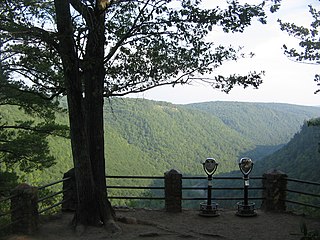
Colton Point State Park is a 368-acre (149 ha) Pennsylvania state park in Tioga County, Pennsylvania, in the United States. It is on the west side of the Pine Creek Gorge, also known as the Grand Canyon of Pennsylvania, which is 800 feet (240 m) deep and nearly 4,000 feet (1,200 m) across at this location. The park extends from the creek in the bottom of the gorge up to the rim and across part of the plateau to the west. Colton Point State Park is known for its views of the Pine Creek Gorge, and offers opportunities for picnicking, hiking, fishing and hunting, whitewater boating, and camping. Colton Point is surrounded by Tioga State Forest and its sister park, Leonard Harrison State Park, on the east rim. The park is on a state forest road in Shippen Township 5 miles (8 km) south of U.S. Route 6.

<span class="mw-page-title-main">Leonard Harrison State Park</span> Park in Pennsylvania, USA

Leonard Harrison State Park is a 585-acre (237 ha) Pennsylvania state park in Tioga County, Pennsylvania, in the United States. It is on the east rim of the Pine Creek Gorge, also known as the Grand Canyon of Pennsylvania, which is 800 feet (240 m) deep and nearly 4,000 feet (1,200 m) across here. It also serves as headquarters for the adjoining Colton Point State Park, its sister park on the west rim of the gorge. Leonard Harrison State Park is known for its views of the Pine Creek Gorge, and offers hiking, fishing and hunting, whitewater boating, and camping. The park is in Shippen and Delmar Townships, 10 miles (16 km) west of Wellsboro at the western terminus of Pennsylvania Route 660.

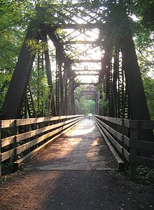
The Jersey Shore, Pine Creek and Buffalo Railway was a railroad built in the early 1880s to give the New York Central and Hudson River Railroad access to the coal regions around Clearfield, Pennsylvania, United States.

<span class="mw-page-title-main">Pennsylvania Route 362</span> State highway in Tioga County, Pennsylvania, US

Pennsylvania Route 362 is a 5.3-mile-long (8.5 km) state highway located in Tioga County, Pennsylvania. The western terminus is at U.S. Route 6 in Shippen Township. The eastern terminus is at Route 660 near Wellsboro in Delmar Township.

<span class="mw-page-title-main">Pennsylvania Route 414</span> State highway in Pennsylvania, United States

Pennsylvania Route 414 is a 79.4-mile-long (127.8 km) state highway located in Lycoming, Tioga, and Bradford counties in Pennsylvania. The western terminus is at PA 44 in Waterville. The eastern terminus is at US 220 in Monroe. The first leg of the highway, between its intersection with PA 44 in Waterville and Blackwell is very narrow and rugged.

<span class="mw-page-title-main">West Rim Trail</span> Hiking trail in Lycoming County, Pennsylvania, United States

The West Rim Trail is a 30.5 mi (49.1 km) linear hiking trail in Lycoming and Tioga Counties in north central Pennsylvania. The trail mostly follows the edge of Pine Creek Gorge, also known as the Grand Canyon of Pennsylvania, which is up to 1,000 feet (300 m) deep and about 2,000 feet (610 m) wide from rim to rim in the area traversed by the trail. The trail is entirely within Tioga State Forest and is known for its large number of vistas overlooking the gorge, which is a National Natural Landmark and one of the deepest gorges in the eastern United States.

<span class="mw-page-title-main">Pine Creek Path</span>

The Pine Creek Path was a major Native American trail in the U.S. State of Pennsylvania that ran north along Pine Creek from the West Branch Susquehanna River near Long Island to the headwaters of the Genesee River.

<span class="mw-page-title-main">Leonard Harrison (businessman)</span>

Leonard Harrison was a lumberman and businessman who spent most of his life in Wellsboro, Pennsylvania and donated Leonard Harrison State Park to the state of Pennsylvania in 1922.

<span class="mw-page-title-main">Pine Creek Gorge</span> A gorge carved by Pine creek in Pennsylvania, United States

Pine Creek Gorge, sometimes called The Grand Canyon of Pennsylvania, is a 47-mile (76 km) gorge carved into the Allegheny Plateau by Pine Creek in north-central Pennsylvania.

<span class="mw-page-title-main">Cammal, Pennsylvania</span> Unincorporated community in Pennsylvania, United States

Cammal is an unincorporated community in McHenry Township, Lycoming County, in the U.S. state of Pennsylvania. It lies along Pine Creek in the Pine Creek Gorge, upstream of Waterville, along Pennsylvania Route 414. Mill Run, which flows through the nearby Tiadaghton State Forest, enters Pine Creek at Cammal. The Pine Creek Rail Trail passes through Cammal.

<span class="mw-page-title-main">Ansonia, Pennsylvania</span> Unincorporated community in Pennsylvania, United States

Ansonia is an unincorporated community in Shippen Township, Tioga County, in the U.S. state of Pennsylvania. It lies along U.S. Route 6, near its junction with Pennsylvania Route 362, between Galeton and Wellsboro.

References

  1. 1 2 Bly, Laura (July 27, 2001). "10 great places to take a bike tour". USA Today . p. 3D.
  2. 1 2 "The Wellsboro Area Chamber of Commerce: Pennsylvania Grand Canyon". Wellsboro Area Chamber of Commerce. Archived from the original on September 13, 2008. Retrieved February 12, 2008.
  3. BicyclePA - Route G (PDF) (Map). Pennsylvania Department of Transportation . Retrieved February 15, 2016.
  4. "Leonard Harrison State Park". Archived from the original on January 24, 2004. Retrieved February 10, 2008.
  5. 1 2 "DCNR opens Pine Creek Rail Trail section to Wellsboro Junction". Archived from the original on June 9, 2011. Retrieved February 10, 2008.
  6. "History of the Tioga State Forest". Archived from the original on March 2, 2004. Retrieved February 10, 2008.
  7. "Bald Eagle Valley Trail". TrailLink. Retrieved April 21, 2024.
Template:Attached KML/Pine Creek Rail Trail
KML is from Wikidata