Pine Mountain Ridge (California)

Last updated
Pine Mountain Ridge
Highest point
Peak Reyes Peak
Elevation 7,510 ft (2,290 m)
Geography
Country United States
State California
Region Ventura County
Parent range Transverse Ranges

Pine Mountain Ridge (or simply Pine Mountain) is a massif of the Transverse Ranges located in northern Ventura County, and entirely within the Los Padres National Forest. [1] The ridge is a large block of Matilija Sandstone, and reaches some of the highest elevations in the southern Transverse Ranges. The north slope of the ridge is part of the Sespe Wilderness.

Transverse Ranges mountain range in California

The Transverse Ranges are a group of mountain ranges of southern California, in the Pacific Coast Ranges physiographic region in North America. The Transverse Ranges begin at the southern end of the California Coast Ranges and lie within Santa Barbara, Ventura, Los Angeles, San Bernardino and Riverside counties. The Peninsular Ranges lie to the south. The name Transverse Ranges is due to their east–west orientation, making them transverse to the general northwest–southeast orientation of most of California's coastal mountains.

Los Padres National Forest United States National Forest in California

Los Padres National Forest is a United States national forest in southern and central California. Administered by the United States Forest Service, Los Padres includes most of the mountainous land along the California coast from Ventura to Monterey, extending inland. Elevations range from sea level to 8,847 feet (2,697 m).

Matilija Sandstone

The Matilija Sandstone is a sedimentary geologic unit of Eocene epoch in the Paleogene Period, found in Santa Barbara and Ventura Counties in Southern California.

Contents

Major peaks on the ridge include, from west to east, Reyes Peak, Haddock Peak, and Thorn Point.

Ecology

The ridge is located in the California montane chaparral and woodlands ecoregion. Lower slopes are dominated by chaparral, while the upper reaches of the mountain support a thick pine forest of Coulter pines and California incense cedars.

California montane chaparral and woodlands

The California montane chaparral and woodlands is an ecoregion defined by the World Wildlife Fund, spanning 7,900 square miles (20,000 km2) of mountains in the Transverse Ranges, Peninsular Ranges, and Coast Ranges of southern and central California. The ecoregion is part of the larger California chaparral and woodlands ecoregion, and belongs to the Mediterranean forests, woodlands, and scrub biome.

Coulter pine species of plant, Coulter Pine

The Coulter pine or big-cone pine, Pinus coulteri, is a native of the coastal mountains of Southern California and northern Baja California (Mexico). Isolated groves are found as far north as the San Francisco Bay Area in Mt. Diablo State Park and Black Diamond Mines Regional Preserve. The species is named after Thomas Coulter, an Irish botanist and physician.

<i>Calocedrus decurrens</i> species of plant

Calocedrus decurrens, with the common names incense cedar and California incense-cedar, is a species of conifer native to western North America, with the bulk of the range in the United States, from central western Oregon through most of California and the extreme west of Nevada, and also a short distance into northwest Mexico in northern Baja California. It grows at altitudes of 50–2,900 metres (160–9,510 ft). It is the most widely known species in the genus, and is often simply called 'incense cedar' without the regional qualifier.

See also

Santa Ynez Mountains mountain range in Southern California

The Santa Ynez Mountains are a portion of the Transverse Ranges, part of the Pacific Coast Ranges of the west coast of North America. It is the westernmost range in the Transverse Ranges.

Topatopa Mountains mountain range in Ventura County, California

The Topatopa Mountains are a mountain range in Ventura County, California, north of Ojai, Santa Paula, and Fillmore. They are part of the Transverse Ranges of Southern California.

Sierra Pelona Mountains mountain range in Southern California, United States

The Sierra Pelona Mountains, or the Sierra Pelona Ridge, is a mountain range of the Transverse Ranges in Southern California. Located in northwest Los Angeles and southern Kern Counties, the range is bordered on the north by the San Andreas fault and lies within and is surrounded by the Angeles National Forest.

Related Research Articles

Santa Susana Mountains mountain range in Southern California, United States

The Santa Susana Mountains are a transverse range of mountains in Southern California, north of the city of Los Angeles, in the United States. The range runs east-west, separating the San Fernando Valley and Simi Valley on its south from Santa Clara River Valley to the north and Santa Clarita Valley to the northeast. The Oxnard Plain is to the west of Santa Susana Mountains.

Peninsular Ranges

The Peninsular Ranges are a group of mountain ranges that stretch 1,500 km (930 mi) from Southern California to the southern tip of the Baja California Peninsula; they are part of the North American Coast Ranges, which run along the Pacific Coast from Alaska to Mexico. Elevations range from 500 to 10,834 feet.

Tehachapi Mountains mountain range in Southern California

The Tehachapi Mountains are a mountain range in the Transverse Ranges system of California in the Western United States. The range extends for approximately 40 miles (64 km) in southern Kern County and northwestern Los Angeles County.

Angeles National Forest

The Angeles National Forest (ANF) of the U.S. Forest Service is located in the San Gabriel Mountains and Sierra Pelona Mountains, primarily within Los Angeles County in southern California. The ANF manages a majority of the San Gabriel Mountains National Monument.

San Rafael Mountains mountain range in Southern California

The San Rafael Mountains are a mountain range in central Santa Barbara County, California, U.S., separating the drainages of the Santa Ynez River and the Santa Maria River. They are part of the Transverse Ranges system of Southern California which in turn are part of the Pacific Coast Ranges system of western North America.

Sierra Madre Mountains (California) mountain range

The Sierra Madre Mountains are a mountain range primarily in northern Santa Barbara County and extending into northwestern Ventura County in Southern California, western United States. It is a range of the Inner South Coast Ranges group, and is the southernmost reach of the California Coast Ranges, which are themselves part of the Pacific Coast Ranges of western North America.

Santa Lucia Range mountain range on the central California coast of the USA

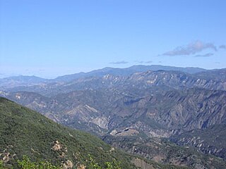
The Santa Lucia Mountains or Santa Lucia Range is a rugged mountain range in coastal central California, running from Monterey County southeast for 105 miles (169 km) into central San Luis Obispo County. It includes Cone Peak, which at 5,158 feet (1,572 m) tall and three miles (5 km) from the coast, is the highest peak in proximity to the ocean in the lower 48 United States. The range forms the eastern boundary of the Big Sur region, and was a barrier to exploring the coast of California for early Spanish explorers.

Mount Pinos mountain in United States of America

Mount Pinos is a mountain located in the Los Padres National Forest on the boundary between Ventura and Kern counties in California. The summit, at 8,847 feet (2,697 m), is the highest point in Ventura County. The mountain is the highest point of the Transverse Ranges west of Tejon Pass, as well as the southernmost point of the Salinian Block.

California Coast Ranges mountain range

The Coast Ranges of California span 400 miles (640 km) from Del Norte or Humboldt County, California, south to Santa Barbara County. The other three coastal California mountain ranges are the Transverse Ranges, Peninsular Ranges and the Klamath Mountains.

Chumash Wilderness

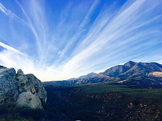
The Chumash Wilderness is a 38,150 acres (15,440 ha) wilderness area within the southern Los Padres National Forest. It is located in the Transverse Ranges, in northern Ventura County and southwestern Kern County in California.

Frazier Mountain mountain in United States of America

Frazier Mountain is a broad, pine-forested peak in the Transverse Ranges System, within the Los Padres National Forest in northeastern Ventura County, California. At 8,017 feet (2,444 m), Frazier Mnt. is the sixteenth-highest mountain in the Transverse Ranges of Southern California.

Dick Smith Wilderness

The Dick Smith Wilderness is a wilderness area in the mountains of eastern Santa Barbara County, California, United States, with a portion in Ventura County. It is completely contained within the Los Padres National Forest, and is northeast of the city of Santa Barbara and north of the city of Ojai. It is most easily accessible from two trailheads off State Route 33, which runs north from Ojai. It is adjacent to the large San Rafael Wilderness on the west and the Matilija Wilderness on the south. Across Highway 33 to the east, and also in the Los Padres National Forest, is the large Sespe Wilderness.

Cobblestone Mountain (California) mountain in United States of America

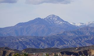
Cobblestone Mountain is a peak in the Topatopa Mountains, in Ventura County, several miles north of Piru, California. At 6,738 feet (2,054 m), it is the highest peak of the Topatopa Mountains, followed by Hines Peak. Snow frequently falls on the mountain during winter.

Sespe Wilderness wilderness area in California

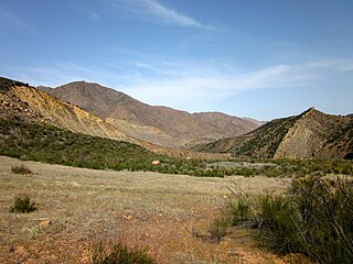
The Sespe Wilderness is a 219,700-acre (88,900 ha) wilderness area in the eastern Topatopa Mountains and southern Sierra Pelona Mountains, within the Los Padres National Forest (LPNF), in Ventura County, Southern California. The wilderness area is primarily located within the Ojai and Mt. Pinos ranger districts of the LPNF.

References

  1. Magney, David. "Pine Mountain Ridge, Ventura County, California", January 8, 2008. Accessed April 29, 2008.