Construction of the community began in 1991, although groundbreaking for what was to become the Nature Preserve started in 1987, when Constellation Real Estate Group began the effort to restore wetlands in an area which had been mined for sand and gravel in the 1940s and 1950s. Several mitigation projects, the term used for this restoration, followed in five phases to replace wetlands filled in by the development of the community, and included the building and enhancement of five large ponds and the planting of shrubs, trees, and grasses native to the area. The Army Corps of Engineers, which oversees such efforts, monitored the progress of the mitigation sites until 1995, when it was determined the efforts had been successful. In 1996, the Piney Orchard Nature Preserve was officially opened.
More than 3500 housing units have been built in Piney Orchard and approximately 8500 residents live there. Constellation turned over the day-to-day supervision of Piney Orchard to the homeowners of the community in 2005. The Piney Orchard Community Association, or "POCA" as it is known, arranges several community-wide social activities and collects annual fees from all homeowners to maintain the aesthetic qualities of the community.
Piney Orchard Ice Arena, located at the corner of Piney Orchard Parkway and Riverscape Drive, had been the practice site for the Washington Capitalshockey team until 2006, when they moved to their newly built practice facility, Kettler Capitals Iceplex in Arlington, Virginia.
Odenton is a census-designated place (CDP) in Anne Arundel County, Maryland, United States, located approximately 10–20 minutes from the state capital, Annapolis. The population was 37,132 at the 2010 census, up from 20,534 at the 2000 census. The town's population growth rate of 80.8% between 2000 and 2010 was the greatest of any town in western Anne Arundel County. Odenton is located west of Annapolis, south of Baltimore, and northeast of Washington.
Hunt Valley is an unincorporated community in Baltimore County, Maryland, United States, near the site of the Maryland Hunt Cup Steeplechase. It lies just north of the city of Baltimore, along York Road, parallel to Interstate 83. The nearby Loch Raven Reservoir is an important landmark and drinking water resource. Its surrounding forested watershed is one of three reservoirs established for the City of Baltimore. Hunt Valley is located at a latitude of 39.5° North and longitude of 76.7° West. It is served by the Cockeysville post office, and is also a neighbor of Timonium. A satellite campus of the Community College of Baltimore County is located in Hunt Valley Town Centre.
The Piney Woods is a temperate coniferous forest terrestrial ecoregion in the Southern United States covering 54,400 square miles (141,000 km2) of East Texas, southern Arkansas, western Louisiana, and southeastern Oklahoma. These coniferous forests are dominated by several species of pine as well as hardwoods including hickory and oak. Historically the most dense part of this forest region was the Big Thicket though the lumber industry dramatically reduced the forest concentration in this area and throughout the Piney Woods during the 19th and 20th centuries. The World Wide Fund for Nature considers the Piney Woods to be one of the critically endangered ecoregions of the United States. The United States Environmental Protection Agency (EPA) defines most of this ecoregion as the South Central Plains.
River Hill is the last and westernmost village to be developed in the town of Columbia, Maryland, United States, though some residents maintain addresses in Clarksville. The village is home to 6,520 residents in 2,096 housing units in 2014. The area was used as a game preserve by James Rouse to entertain clients and personal hunting during the buildout of the Columbia project. In 1976, County Executive Edward L. Cochran selected the 784-acre parcel owned by Howard Research and Development for an alternate location for a county landfill; a task force selected Alpha Ridge Landfill instead. Residential construction started in 1990. It is bounded by Maryland Route 108 and Maryland Route 32, and is centered on Trotter Road. The village is divided into two neighborhoods: Pheasant Ridge and Pointers Run, with about 6,500 residents.
The Washington, Baltimore and Annapolis Trail (WB&A) is a 10.25-mile (16.50 km) long discontinuous rail trail from Lanham to Odenton in Maryland. Despite its name, it does not actually connect with Washington, D.C., Annapolis or Baltimore; its name is taken from the Washington, Baltimore and Annapolis Electric Railway, from which the right-of-way comes. The trail exists in two separate pieces, one in Anne Arundel County and the other in Prince George's County, separated by the lack of a bridge over the Patuxent River. The bridge's construction and the trail's alignment was delayed for over a decade due to a property dispute; however, the trail was realigned and plans exist to complete a bridge by 2021. Additional plans exist to extend the trail southward to the Washington, D.C. border.
Andorra is a neighborhood in Northwest Philadelphia, which is a section of the city of Philadelphia, Pennsylvania. Andorra is a part of Roxborough, being within the borders of the original Roxborough Township and having the same zip code (19128). At some point during the 19th or 20th century, Andorra developed a cultural identity as a neighborhood within Roxborough. Andorra was named "Andorra" after a fancied resemblance to the small country of the same name which sits astride the Pyrenees between France and Spain.
The Appalachian mixed mesophytic forests is an ecoregion of the temperate broadleaf and mixed forests biome, as defined by the World Wildlife Fund. It consists of mesophytic plants west of the Appalachian Mountains in the Southeastern United States.
Broadlands is a census-designated place (CDP) in Loudoun County, Virginia, United States. It is a 1,500-acre (610 ha) master-planned community started and developed by Van Metre Homes in the 1990s. It is built on wetlands and is certified as a Community Wildlife Habitat by the National Wildlife Federation.
The Columbus and Franklin County Metro Parks are a group of 19 metropolitan parks in and around Columbus, Ohio. They are officially organized into the Columbus and Franklin County Metropolitan Park District. The Metro Parks system was organized in 1945 under Ohio Revised Code Section 1545 as a separate political division of the state of Ohio. The Metro Parks are overseen by a Board of Park Commissioners consisting of three citizens appointed to three-year terms without compensation by the Judge of the Probate Court of Franklin County, Ohio. The Board in turn appoints an Executive Director responsible for operations and management of the parks.
4S Ranch is a locale of San Diego County, California. It is located about 25 miles (40 km) north of downtown San Diego and 13 miles (21 km) east of the Pacific Ocean in the North County Inland area of San Diego. To the east of 4S Ranch is the San Diego community of Rancho Bernardo. To the west is the Santa Fe Valley, which includes Rancho Santa Fe. Lake Hodges forms the northern border of the community while Black Mountain Ranch, which includes Del Sur and Santaluz, and Rancho Peñasquitos are both situated to the south. The ZIP Code is 92127, and the community is inside area code 858.
Russett is an unincorporated planned community of 613 acres (2.48 km2) within the Maryland City CDP in far-western Anne Arundel County, Maryland, United States, near the city of Laurel. It is situated in a park-like setting complemented by 12 miles (19 km) of walking trails and a 70-acre (280,000 m2) lake nature preserve.
Glacial Ridge National Wildlife Refuge was created on October 12, 2004, the 545th National Wildlife Refuge in the United States. Its creation was the result of cooperation between at least 30 agencies or governmental entities. The creation of the refuge was spearheaded by The Nature Conservancy, and the initial endowment of 2,300 acres (9.3 km2) of land was donated by the Conservancy. In light of its planned final size of 37,756 acres (153 km2), it is described by the US Fish and Wildlife Service as "the largest tallgrass prairie and wetland restoration project in U.S. history."
The Southtowns is a region of Western New York, United States, that lies within the snowbelt or ski country. It includes the southern suburbs of Buffalo, New York. This is the common name for the southern part of Erie County, New York.
Cherry Orchard Bog Natural Area Preserve is a 354-acre (143 ha) Natural Area Preserve located in Sussex and Prince George counties, Virginia. The preserve is owned and maintained by the Virginia Department of Conservation and Recreation (DCR). It does not include improvements for public access, and visitors must make arrangements with a state-employed land steward prior to visiting. The preserve is located along the right of way for a power line, receiving acidic, low-nutrient groundwater.
Goffle Hill, also referred to as Goffle Mountain and historically known as Totoway Mountain and Wagaraw Mountain, is a range of the trap rock Watchung Mountains on the western edge of the Newark Basin in northern New Jersey. The hill straddles part of the border of Bergen County and Passaic County, underlying a mostly suburban setting. While hosting patches of woodlands, perched wetlands, and traprock glades, the hill is largely unprotected from development. Extensive quarrying for trap rock has obliterated large tracts of the hill in North Haledon, and Prospect Park. Conservation efforts seeking to preserve undeveloped land, such as the local Save the Woods initiative (2007–present), are ongoing.
Piney Run Park is a nature park in Sykesville, located in Carroll County, Maryland. It is Carroll County's oldest developed park and hosts thousands of visitors annually. The park encompasses 550 acres of fields, forest and open spaces, features over 15 miles of hiking trails, a 300-acre lake and many sports and recreational facilities. Prior to being a park, this land was a private farm.
The Trexler Nature Preserve is an 1,108 acre county park owned and maintained by Lehigh County in the Lehigh Valley region of Pennsylvania. The preserve is situated in Lowhill Township and North Whitehall Township and the land that comprises the preserve was originally purchased between 1901 and 1911 by local industrialist General Harry Clay Trexler.
The Wetlands Initiative (TWI) is a non-profit conservation organization headquartered in Chicago, Illinois, United States. The Wetlands Initiative works with nonprofit and government partners and local communities to advance wetland restoration and science in the Midwestern United States. The organizational vision of TWI is: "A world with plentiful healthy wetlands improving water quality, climate, biodiversity, and human well-being."
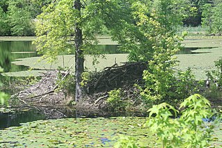
Piney Orchard Nature Preserve is a 45-acre (18 ha) protected wetland forest with several miles of improved trails located in southern Odenton, Maryland. The Preserve is surrounded by 1,500 acres of river woodland between the residential communities of Piney Orchard, Two Rivers, Woodwardville, and Amberfield. Piney Orchard Nature Preserve is bordered by the Patuxent Research Refuge to the west, the Little Patuxent River to the south, and the Washington, Baltimore and Annapolis Trail to the east.
This page is based on this Wikipedia article Text is available under the CC BY-SA 4.0 license; additional terms may apply. Images, videos and audio are available under their respective licenses.