
Richmond is a city in western Contra Costa County, California, United States. The city was incorporated on August 7, 1905, and has a city council. Located in the San Francisco Bay Area's East Bay region, Richmond borders San Pablo, Albany, El Cerrito and Pinole in addition to the unincorporated communities of North Richmond, Hasford Heights, Kensington, El Sobrante, Bayview-Montalvin Manor, Tara Hills, and East Richmond Heights, and for a short distance San Francisco on Red Rock Island in the San Francisco Bay. Richmond is one of two cities, the other being San Rafael, that sits on the shores of both San Francisco Bay and San Pablo Bay.

Contra Costa County is located in the state of California in the United States. As of the 2020 census, the population was 1,165,927. The county seat is Martinez. It occupies the northern portion of the East Bay region of the San Francisco Bay Area and is primarily suburban. The county's name refers to its position on the other side of the bay from San Francisco. Contra Costa County is included in the San Francisco–Oakland–Berkeley, CA Metropolitan Statistical Area.

San Pablo Bay is a tidal estuary that forms the northern extension of San Francisco Bay in the East Bay and North Bay regions of the San Francisco Bay Area in northern California.

Union Iron Works, located in San Francisco, California, on the southeast waterfront, was a central business within the large industrial zone of Potrero Point, for four decades at the end of the nineteenth and beginning of the twentieth centuries.

The Berkeley Hills are a range of the Pacific Coast Ranges that overlook the northeast side of the valley that encompasses San Francisco Bay. They were previously called the "Contra Costa Range/Hills", but with the establishment of Berkeley and the University of California, the current usage was applied by geographers and gazetteers.
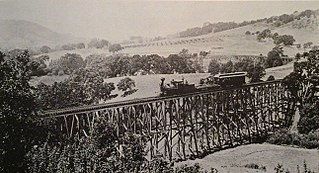
The California and Nevada Railroad was a 3 ft narrow gauge steam railroad which ran in the East Bay of the San Francisco Bay Area in the late 19th century. It was incorporated on March 25, 1884. J.S. Emery was listed as the railroad's president, for which present day Emeryville is named. On March 1, 1885 the track was completed between Oakland and San Pablo via Emeryville. The track to Oak Grove was completed on January 1, 1887.
Richmond Annex or The Annex is a neighborhood in southeastern Richmond, California. It is mostly residential and located between San Pablo Avenue/El Cerrito to the east, San Francisco Bay to the west, Central Avenue/Cerrito Creek/Albany Hill/Albany/Alameda County to the south, and Potrero Avenue/Pullman to the north. Carlson Boulevard is the main thoroughfare through the annex, connecting downtown Richmond with downtown El Cerrito.

Wildcat Canyon Regional Park is a 2,429-acre (983 ha) East Bay Regional Parks District park located within the city limits of Richmond in Contra Costa County in the San Francisco Bay Area of California. It includes a portion of Wildcat Canyon as well as a portion of the adjoining San Pablo Ridge, and is directly connected to the more heavily used Tilden Regional Park.

Brickyard Cove is a body of water in the Brickyard Cove neighborhood of the Point Richmond area of Richmond, California. The cove is situated between the Harbor Channel, a deepwater shipping channel that connects the San Francisco Bay with the Port of Richmond and the mainland. The cove is located between Point Potrero and Ferry Point. A marina is located in the cove and the Red Oak Victory part of Rosie the Riveter/World War II Homefront National Historic Park is docked in the western end of the cove.
Point Isabel is a promontory on the eastern shore of San Francisco Bay in the Richmond Annex neighborhood of Richmond, USA.
The Richmond Greenway is a pedestrian and bicycle path in Richmond, California.

The Eastshore and Suburban Railway (E&SR) was a formerly independent unit of the historic San Francisco Bay Area Key System which ran streetcar trains in Richmond, California, San Pablo, and El Cerrito. There were several lines with terminals at Point Richmond, North Richmond, the county line with Alameda County, what is now San Pablo, and Grand Canyon/East Richmond/Alvarado Park. Service to Oakland required a transfer to Oakland Traction Company trains at the County Line station and service to San Francisco required an additional transfer in Oakland. The systems were later consolidated into the Key System. Service began to be replaced by buses beginning on August 1, 1932, with the conversion of the East Richmond/23rd Street line to buses. Lines were converted to buses one at a time with the last remaining line being in September 1933. Fares were originally 5 cents and were raised to 7 cents over time at the time of the last runs.

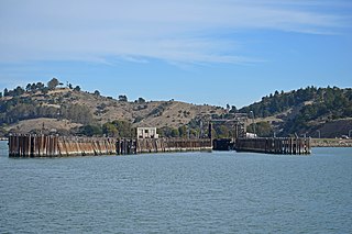
Point San Pablo Harbor is a marina and small community at the far end of Point San Pablo in San Pablo Bay, within Richmond, in Contra Costa County, California. It is located at 1900 Stenmark Drive, Richmond CA 94801.
San Pablo Peninsula is a peninsula in western Richmond, between San Pablo Bay and San Rafael Bay, in southwestern Contra Costa County, California.
San Pablo Ridge is a small mountain range in western Contra Costa County from Pinole to Orinda between Wildcat Canyon and San Pablo Canyon. The western flank is part of the Wildcat Creek watershed and the eastern flank is part of the San Pablo Creek watershed. To the west are the Berkeley Hills, and to the east, the Sobrante Ridge. The highest point on the San Pablo Ridge is Vollmer Peak, formerly called "Bald Peak", located near the point where it meets the Berkeley Hills at the head of Wildcat Canyon.

Richmond Inner Harbor is a deepwater body of water in Richmond, California.

The San Francisco Bay National Estuarine Research Reserve is one of 27 reserves established as part of the United States National Estuarine Research Reserve System. The reserve is used to promote San Francisco Bay wetlands and estuary research, education, and stewardship.

The Potrero Hills also known as the Potrero Ridge and Point Molate Hills is a chaparral and forested escarpment that crests northwest to southeast along the San Pablo Peninsula in Richmond, California.
Castro Point is a cape in western Richmond, California, United States.
Ferry Point is a cape on the San Francisco Bay in western Richmond, California, United States.

