
Transport in the Dominican Republic utilizes a system of roads, airports, ports, harbours, and an urban railway.

Santo Domingo, once known as Santo Domingo de Guzmán and Ciudad Trujillo, is the capital and largest city of the Dominican Republic and the largest metropolitan area in the Caribbean by population. As of 2022, the city and immediate surrounding area had a population of 1,973,664 while the total population is 4,579,536 when including Greater Santo Domingo. The city is coterminous with the boundaries of the Distrito Nacional, itself bordered on three sides by Santo Domingo Province.

San Cristóbal is a province in the southern region of Dominican Republic, located west of the capital Santo Domingo. With approximately 642,000 inhabitants, it is the fourth most populated province in the country, only behind Santo Domingo, Santiago and the National District. It borders the provinces Monseñor Nouel (north), Monte Plata (northeast), Santo Domingo (east), Peravia (west) and San José de Ocoa (northwest). The Caribbean Sea borders the province to the south. The provincial capital is the city of San Cristóbal.

San Cristóbal is a city in the southern region of Dominican Republic. It is the municipal (municipio) capital of the San Cristóbal province. The municipality is located in a valley at the foothills of the mountains belonging to the Cordillera Central, between the Nigua and Nizao rivers. Within this municipality there is one municipal district : Hato Damas.
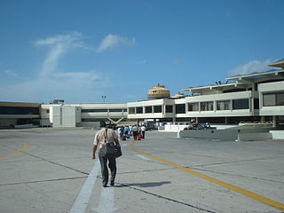
Las Américas International Airport is an international airport located in Punta Caucedo, near Santo Domingo and Boca Chica in the Dominican Republic. The airport is run by Aeropuertos Dominicanos Siglo XXI (AERODOM), a private corporation based in the Dominican Republic, under a 25-year concession to build, operate, and transfer (BOT) six of the country's airports. Las Américas usually receives a wide variety of long-, mid-, and short-haul aircraft. Santo Domingo's other airport, La Isabela, is much smaller and used by light aircraft only.

The Port of Philadelphia is located on the Delaware River in Philadelphia in the U.S. state of Pennsylvania.
Sans souci is French for "no worries" or "carefree".

Barahona, also known as Santa Cruz de Barahona, is the main city of the Barahona Province, in the southwest of the Dominican Republic. It has one of the most active ports in the region, as well as many ecotourism attractions. The city is a centre of sugar production and industry. Barahona is also known for being the only place where the rare Larimar stone can found.

La Romana is a municipality and capital of the southeastern province of La Romana, opposite Catalina Island. It is one of the 10 largest cities in the Dominican Republic with a population estimated in 2010 at 130,426 within the city limits, of whom 127,623 are urban and 2,803 are rural. The name Romana comes from the word "Bomana", a name given by Indians to what is known today as Romana River.

Puerto Plata, officially known as San Felipe de Puerto Plata, is the third-largest city in the Dominican Republic, and capital of the province of Puerto Plata. The city is a trading port. Puerto Plata has resorts such as Playa Dorada and Costa Dorada, which are located east of the city proper. There are 100,000 hotel beds in the city. The first aerial tramway of the Caribbean is located in Puerto Plata, in which visitors can ride up to the Pico Isabel de Torres, a 793-meter (2600-foot) high mountain within the city.
DR-2 is the second numbered national highway in the Dominican Republic. Its common name is Carretera Sánchez in honor of Francisco del Rosario Sánchez, one of the founding fathers. In the city of Santo Domingo, it is known as Autopista 30 de Mayo. The highway serves as the main connection to the southwestern region of the country. The highway's eastern terminus is located in Santo Domingo and continues on a western route through until its end in Comendador for a total length of approximately 255 kilometers. The route is mainly a two-lane roadway even though it has been recently expanded from San Cristobal to Baní and has been largely replaced by the faster DR-6 route from Santo Domingo to San Cristobal. Due to its locality and heavy traffic DR-2 has been undergoing an expansion project to make it a two-lane expressway and allow better traffic flow. DR-2 has one toll location just outside the boundaries of Greater Santo Domingo before entering the town of Haina.

Santo Domingo Este is a municipality and the provincial capital of the Santo Domingo province in the Dominican Republic. It has one municipal district, San Luis.

Ciudad Colonial is the historic central neighborhood of the Dominican Republic's capital Santo Domingo. It is the oldest continuously inhabited European-established settlement in the Americas. The area has been declared a World Heritage Site by UNESCO. It is also known as Zona Colonial or more colloquially as "La Zona".

The Captaincy General of Santo Domingo was the first colony in the New World, established by Spain in 1492 on the island of Hispaniola. The colony, under the jurisdiction of the Real Audiencia of Santo Domingo, was granted administrative powers over the Spanish possessions in the Caribbean and most of its mainland coasts, making Santo Domingo the principal political entity of the early colonial period.

The Ozama Fortress, also formerly known as the city wall's Homage tower. It is one of the surviving sections of the Walls of Santo Domingo, which is recognized by UNESCO as being the oldest military construction of European origin in the Americas. It was built between 1502-1508 by the Spanish at the entrance to Santo Domingo's Ciudad Colonial, Dominican Republic, and overlooking the Ozama River. Named after this river, the castle, also referred to as "La Fortaleza" or "The Fortress". It was declared by UNESCO as a World Heritage Site, together with the other historical monuments of the Ciudad Colonial.
The Multimodal Caucedo Port is located in Caucedo, Boca Chica, Santo Domingo Province, Dominican Republic. This harbor is only used for cargo operations incoming from several countries in the Caribbean zone and is the youngest and the most modern port in the island.

Tourism in the Dominican Republic is an important sector of the country's economy. More than 8.5 million tourists visited the Dominican Republic in 2022, making it the most popular tourist destination in the Caribbean and putting it in the top 5 overall in the Americas. The industry accounts for 11.6% of the nation's GDP and is a particularly important source of revenue in coastal areas of the country. The nation's tropical climate, white sand beaches, diverse mountainous landscape and colonial history attracts visitors from around the world.
Los Mameyes is a neighbourhood in the city of Santo Domingo Este in the province of Santo Domingo of the Dominican Republic. This neighbourhood is populated in particular by individuals from the middle classes.

The Church and Convent of los Dominicos of the Colonial City of Santo Domingo in the Dominican Republic, is the oldest Catholic building in continuous use in the Americas, and also, according to the UNESCO, it was the headquarters of the first university in the Americas, which was called the Universidad Santo Tomás de Aquino. Today it is part of the Colonial City complex, as a World Heritage Site.
Lisandro José Macarulla Tavárez is a businessman and entrepreneurial leader from the Dominican Republic.


