
Ecuador, officially the Republic of Ecuador, is a country in northwestern South America, bordered by Colombia on the north, Peru on the east and south, and the Pacific Ocean on the west. Ecuador also includes the Galápagos Islands in the Pacific, about 1,000 kilometers (621 mi) west of the mainland. The country's capital is Quito, but its largest city is Guayaquil.

Ecuador is a country in western South America, bordering the Pacific Ocean at the Equator, for which the country is named. Ecuador encompasses a wide range of natural formations and climates, from the desert-like southern coast to the snowcapped peaks of the Andes mountain range to the plains of the Amazon Basin. Cotopaxi in Ecuador is one of the world's highest active volcanos. It also has a large series of rivers that follow the southern border and spill into the northwest area of Peru.
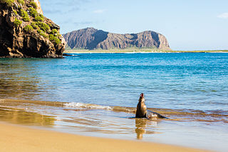
The Galápagos Islands are an archipelago of volcanic islands in the Eastern Pacific, located around the Equator 900 km (560 mi) west of South America. They form the Galápagos Province of the Republic of Ecuador, with a population of slightly over 33,000 (2020). The province is divided into the cantons of San Cristóbal, Santa Cruz, and Isabela, the three most populated islands in the chain. The Galápagos are famous for their large number of endemic species, which were studied by Charles Darwin in the 1830s and inspired his theory of evolution by means of natural selection. All of these islands are protected as part of Ecuador's Galápagos National Park and Marine Reserve.

Guayas is a coastal province in Ecuador. It is bordered to the west by Manabí, Santa Elena, and the Pacific Ocean ; to the east by Los Ríos, Bolívar, Chimborazo, Cañar, and Azuay; to the north by Los Ríos and Bolívar; and to the south by El Oro and the Pacific Ocean.

Pacific coast may be used to reference any coastline that borders the Pacific Ocean.

The Asia–Pacific (APAC) is the region of the world adjoining the western Pacific Ocean. The region's precise boundaries vary depending on context, but countries and territories in Australasia, East Asia, and Southeast Asia are often included. In a wider context, Central Asia, North Asia, the Pacific Islands, South Asia, West Asia, and even Pacific-adjoining countries in the Americas can be included. For example, the Asia-Pacific Economic Cooperation (APEC) includes five countries in the New World. The term has become popular since the late 1980s in commerce, finance, and politics. Despite the heterogeneity of the regions' economies, most individual nations within the zone are emerging markets experiencing rapid growth. Sometimes, the notion of "Asia–Pacific excluding Japan" (APEJ) is considered useful.

The Guayas River also called Rio Guayas is a major river in western Ecuador. It gives name to Guayas Province and is the most important river in South America that does not flow into the Atlantic Ocean or any of its marginal seas. Its total length, including the Daule River, is 389 km (241 mi). The Guayas River's drainage basin is 34,500 km2 and it has an average discharge of 70,000 cu ft/s. It is the national river of Ecuador and is present on the coat of arms of Ecuador.
A cordillera is an extensive chain and/or network system of mountain ranges, such as those in the west coast of the Americas. The term is borrowed from Spanish, where the word comes from cordilla, a diminutive of cuerda ('rope').

Tumbes is a province in Peru, located in the region of the same name. It borders the Pacific Ocean on the north, the Zarumilla Province on the east, the Piura Region and Ecuador on the south and the Contralmirante Villar Province on the west. Its capital is Tumbes, which is also the regional capital.

Zarumilla is one of the three provinces of the Tumbes Region in northwestern Peru. It borders the Pacific Ocean on the north, Ecuador on the south and east, and the Tumbes Province on the west.
Eloy Alfaro International Airport is a combination civilian airport and military air base on the Pacific coast near Manta, a city in the Manabí Province of Ecuador. The airport, also known as Eloy Alfaro Air Base, is named in honor of Eloy Alfaro, a former president of Ecuador. It was inaugurated by the Ecuadorian Air Force on October 24, 1978. It is the fourth-busiest airport in Ecuador.

Geology of Colombia refers to the geological composition of the Republic of Colombia that determines its geography. Most of the emerged territory of Colombia covers vast areas within the South American plate, whereas much submerged territory lies within the Caribbean plate and the Nazca plate.
The following outline is provided as an overview of and topical guide to Ecuador:
The Chorrera culture or Chorrera tradition is a Late Formative indigenous culture that flourished between 1300 BCE and 300 BCE in Ecuador. Chorrera culture was one of the most widespread cultures in pre-Columbian Ecuador, spanning the Pacific lowlands to the Andean highlands, and even into southern Colombia.

The South American Division (SAD) of Seventh-day Adventists is a sub-entity of the General Conference of Seventh-day Adventists, which oversees the Church's work in most of South America, which includes the nations of Argentina, Bolivia, Brazil, Chile, Ecuador, Peru, Paraguay, and Uruguay. Its headquarters is in Brasilia, Brazil. The Division membership as of June 30, 2021 is 2,545,366

Sucre Canton is a canton of Ecuador, located in the Manabí Province. Its capital is the city of Bahía de Caráquez. Its population at the 2001 census was 52,158. The canton owes its name to Marshal Antonio José de Sucre.

This is a survey of the postage stamps and postal history of the Wallis and Futuna Islands.
This is a survey of the postage stamps and postal history of Nauru.

Ecuador has many beaches for surfing: the coast of Ecuador is 2,237 km long. Surfable waves are available in Ecuador year-round, and surfers enjoy the mild year-round weather, especially in the northern region where the weather conditions attract many surfers from all over the world. Within this part of South America, Ecuador's neighbors Chile and Peru also offer great surfing. Many surfers in Ecuador use a protective wetsuit. Surf tourism is very important to the local economy, and the beaches offer significant enjoyment because of top quality waves combined with affordable prices for lodging and food compared to other surf destinations. There's also a national marine reserve off the coast, which has a gigantic whale population.

The Malpelo Plate is a small tectonic plate (microplate) located off the coasts west of Ecuador and Colombia. It is the 57th plate to be identified. It is named after Malpelo Island, the only emerged part of the plate. It is bounded on the west by the Cocos Plate, on the south by the Nazca Plate, on the east by the North Andes Plate, and on the north by the Coiba Plate, separated by the Coiba Transform Fault (CTF). This microplate was previously assumed to be part of the Nazca Plate. The Malpelo Plate borders three major faults of Pacific Colombia, the north to south striking Bahía Solano Fault in the north and the Naya-Micay and Remolino-El Charco Faults in the south.

