Related Research Articles

Weedpatch is an unincorporated community and census-designated place (CDP) in Kern County, California, United States. Weedpatch is 10 miles (16 km) south-southeast of Bakersfield. It is considered to be one of the poorest areas in Kern County. As of the 2010 census it had a population of 2,658.

Moncks Corner is a town in and the county seat of Berkeley County, South Carolina, United States. The population was 7,885 at the 2010 census. As defined by the U.S. Census Bureau, Moncks Corner is included within the Charleston-North Charleston, SC Metropolitan Statistical Area.

Meggett is a town in Charleston County, South Carolina, United States. The population was 1,226 at the 2010 census. Meggett is part of the Charleston-North Charleston-Summerville metropolitan area.

Rockville is a town in Charleston County, South Carolina, United States, that was founded in 1784. The population was 134 at the 2010 census. Rockville is part of the Charleston-North Charleston-Summerville metropolitan area.

Chesterfield is a town in Chesterfield County, South Carolina, United States. The population was 1,472 at the 2010 census. It is the county seat of Chesterfield County. At the time of the 2010 census, Chesterfield was the least populous of all of South Carolina's county seats.

Elloree is a town in Orangeburg County, South Carolina, United States. The population was 692 at the 2010 census.
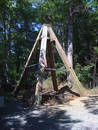
The Reed Gold Mine is located in Midland, Cabarrus County, North Carolina, and is the site of the first documented commercial gold find in the United States. It has been designated a National Historic Landmark because of its importance and listed on the National Register of Historic Places
Terrell is an unincorporated community in Catawba County, North Carolina, United States. For the 2010 census, it was included within the Lake Norman of Catawba CDP.

West Ashley, or more formally, west of the Ashley, is one of the six distinct areas of the city proper of Charleston, South Carolina. As of July 2022, its estimated population was 83,996. Its name is derived from the fact that the land is west of the Ashley River.
Oak Grove is an unincorporated community in northern Surry County, North Carolina, United States, located near Bottom.
The Charlesfort-Santa Elena Site is an important early colonial archaeological site on Parris Island, South Carolina, United States. It contains the archaeological remains of a French settlement called Charlesfort, settled in 1562 and abandoned the following year, and the later 16th-century Spanish settlement known as Santa Elena. The Spanish remains include a fort built directly on top of the abandoned Charlesfort remains.
Frogmore is an unincorporated community on St. Helena Island in Beaufort County, South Carolina, United States, along U.S. Route 21.

Wedgefield is an unincorporated community in the High Hills of Santee area in western Sumter County, South Carolina, United States. Wedgefield is also a Census Designated Place (CDP). Wedgefield was so named because its location was likened to a "wedge" into the High Hills of Santee. In the 18th and 19th centuries it was the location of many plantations, notably those of the Singleton family, which produced First Lady of the United States, Angelica Singleton Van Buren. Today the plantations are gone except for their cemeteries and Wedgefield is today noted as the location of a state park, a state forest and other recreational places. When the railroad came through in the 19th century, the commercial center of Wedgefield developed at the intersection of the railroad, Kings Highway and Wedgefield Road. It has its own post office with the Zip Code of 29168.
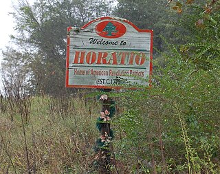
Horatio is an unincorporated community in the High Hills of Santee area in western Sumter County, South Carolina, United States.
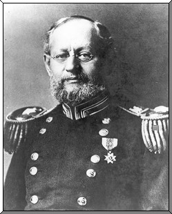
Hagood is an unincorporated community in the High Hills of Santee area in western Sumter County, South Carolina, United States. It lies west of South Carolina Highway 261, north of Stateburg and is the location of Magnolia Hall, which is listed on the National Register of Historic Places. Its mail now comes from Rembert zip code 29128. The community was originally called Sander's Station by the South Carolina Railway, apparently for Dr. Swepson Saunders, the owner of Magnolia Hall plantation, on which it was located, but was renamed Hagood for Johnson Hagood, brigadier general in the Confederate States Army and later governor of South Carolina.

Harbor Island is a small residential island located 14 miles (22 km) east of Beaufort, South Carolina. It is one of the Carolina Sea Islands. The swing drawbridge has been replaced by a fixed high level bridge, Harbor River Bridge, that connects the island to Saint Helena Island towards the west. A small causeway crossing Johnson Creek connects Harbor Island with Hunting Island towards the south.
Robertville is an unincorporated community in Jasper County, South Carolina, United States. It is named after the Robert family who initially settled in the area and was also the birthplace of Henry Martyn Robert, founder of Robert's Rules of Order. The community is accessible via U.S. Highway 321 and is located about halfway between Hardeeville and Estill. It is also located on the historic Sister's Ferry road where the left wing of General William Sherman's army marched through and torched the town in the "Carolinas Campaign."

Seabrook is an unincorporated community and census-designated place (CDP) located in Beaufort County, South Carolina, United States. It was first listed as a CDP in the 2020 census with a population of 1,255.
Gillisonville is an unincorporated community and census-designated place (CDP) in Jasper County, in the U.S. state of South Carolina. It was first listed as a CDP in the 2020 census with a population of 183.
References
- ↑ Federal Writers' Project (1938). The Ocean Highway: New Brunswick, New Jersey to Jacksonville, Florida. Works Progress Administration. p. 141.
- ↑ "National Register Information System". National Register of Historic Places . National Park Service. July 9, 2010.
Municipalities and communities of Beaufort County, South Carolina, United States | ||
|---|---|---|
| Cities |  | |
| Towns | ||
| CDPs | ||
| Other communities | ||
| Footnotes | ‡This populated place also has portions in an adjacent county or counties | |
32°14′17″N80°57′51″W / 32.23806°N 80.96417°W
| | This South Carolina state location article is a stub. You can help Wikipedia by expanding it. |