Proposed wildlife crossings in Jackson, Wyoming

Last updated

Many animal migration patterns are still intact in the greater Jackson area due to the large quantity of protected land. Large animals such as elk, mule deer, and pronghorn have separate winter and summer habitats and are moving in the spring and fall. Elk, moose, and other large animals also converge in the low-lying areas around Jackson during the winter months to escape deep snow at higher elevations. All of this movement increases the likelihood of wildlife-vehicle collisions on roads. [1]

Contents

Jackson and Teton County have recorded over 5,000 wildlife–vehicle collisions since 1990. [2] As a result, the Western Transportation Institute (WTI) was tasked with completing a report to examine the feasibility of a wildlife-crossing master plan. In May 2018, the WTI and Teton County published the Teton County Wildlife Crossing Master Plan. The master plan studied and identified seven highway segments suitable for wildlife crossings and other vehicle-collision mitigation. These highways include U.S. Route 191 (US 191), US 26, US 89, US 26, Wyoming Highway 220 (WYO 22) and WYO 390. [3]

Overview

From 2010 to 2018, 43 animal species were recorded in Teton County's wildlife–vehicle collision database. Elk (327 collisions), moose (143), and mule deer (1,427) had the largest numbers of collisions in the Jackson area. [2] The WTI examined crash and carcass data when it developed the Teton County Wildlife Crossing Master Plan. Although the data tends to reflect large- and medium-sized collisions, safety and conservation concerns extend beyond these documented encounters; ecological concerns extend to aquatic habitats and fish populations. [3]

Although traffic and animal-migration patterns vary by season, there is a constant presence of vehicular traffic and large mammals in and around Jackson. Each of the seven identified highways averages 10,000 vehicles per day, with volumes varying from 23,000 vehicles per day at peak season on one road to 1,500 vehicles per day on the lowest-volume stretch of highway. [3]

Human safety and economic impact

Vehicle collisions with large mammals can result in property damage, injury and death. The Wyoming Department of Transportation (WYDOT) estimates that there is a 79-percent chance of a driver's colliding with wildlife on Wyoming roads. [4] WYDOT also estimates that these collisions result in $50 million in damage per year (vehicle damage and personal-injury costs). [5] WYDOT estimates that the average animal collision in Wyoming will cost a driver $11,600. [6] In a 2003 study by the Jackson Hole Wildlife Foundation, it was estimated that wildlife collisions in Teton County cost $1.2 million per year. [7] More recently, the Jackson Hole Wildlife Foundation completed an economic impact assessment for 2016-2017 that found total economic loss from wildlife collisions to be $3,172,837 in Teton County. [8]

The Nature Conservancy (TNC) estimates that wildlife collisions cost Wyoming drivers $25 million in injury and property damage, and $24 million to taxpayers in lost wildlife productivity. TNC also estimates that Wyoming wildlife collision costs involving mule deer, elk and moose are $10,500, $25,319, and $37,873, respectively. [9] A number of studies document the economic value of wildlife, including the major local economic drivers of tourism, recreation and hunting. [10] Studies indicate that there are approximately 211 fatalities and 29,000 human injuries in the United States each year due to vehicle collisions with wildlife. [11]

Biological conservation

Wildlife is impacted by roads and traffic in five broad categories: loss of habitat, road mortality, barriers to wildlife movement, decreases in habitat quality, and the introduction of non-native species. These categories are used to estimate the impact of roads on biological conservation. In addition to deer, elk and moose, animals with high conservation value in the area include river otter, lynx, grizzly bear, and bison. [3] According to Anthony Clevenger of the WTI, "generalizations about the conservation value of habitat corridors remain elusive because of the species-specific nature of the problem". [12] Due to the complex nature of habitats in and around Jackson, the Teton County Wildlife Crossing Master Plan evaluates the biological conservation value of each roadway based on the migration patterns of large and medium-sized mammals most likely to encounter vehicle traffic on a specific route. [3]

The Jackson Hole Wildlife Foundation (JHWF) demonstrated the urgency of this problem by tracking moose-specific deaths due to vehicle collisions in the Jackson area. JHWF tracked 50 moose deaths due to collisions over a decade, and compared that to the estimated 70 moose that live near town. Their research indicates that this moose population could be at risk due to the frequency of collisions. [13] JHWF believes that it "can save an average of 190 moose, 210 elk and 360 deer every 20 years" with the construction of wildlife crossings. [14]

In assessing biological conservation value, the concept of ecological permeability becomes an important element of the master plan. Ecological permeability has broad scientific consensus. Although vehicle–wildlife collisions are the most acute aspect of biological conservation with respect to wildlife overpasses, the ability for species to migrate and interact with the larger ecosystem is considered crucial for the health and maintenance of species and ecosystem. Research also demonstrates that facilitating permeability requires that wildlife crossings be species-specific; for example, ungulates prefer overpasses and carnivores prefer underpasses. [15] The Teton County Master Plan takes these biological-conservation and permeability factors into account in its analysis and planning process. [3]

Proposed locations

The Teton County Wildlife Crossing Master Plan has identified 12 crossing priorities, and has ranked the locations based on eight criteria: land security, political viability, key-partner support, technical feasibility, long-term solution, human-safety impact, wildlife-mortality impact, and habitat connectivity value. [16] Among other data sets, the master-plan research team used extensive nature mapping, collision data, WYDOT traffic data, and migration data for mule deer, elk and moose to compile the rankings. [3]

Research indicates that combining wildlife crossings with other mitigation measures can result in an 83-percent reduction in collisions. Without complex planning and the integration of multiple measures, an average mitigation reduces collisions by 40 percent. [17] Some advocates cite statistics indicating that a combination of fencing and crossing structures can reduce collisions by 90 percent. [14]

Recommended crossing locations are ranked as follows:

  1. Highway 22 / 390 Intersection / Snake River Bridge
  2. Highway 22 Spring Creek to Bar Y
  3. Camp Creek (near-term, non-structural measures)
  4. Camp Creek (Hoback Junction to Hoback Canyon)
  5. North of Jackson to Fish Hatchery
  6. South of Jackson to Rafter J
  7. Horse Creek to Hoback Junction
  8. Broadway (Flat Creek Bridge near five-way intersection to High School Road)
  9. Teton Pass west side (WY 22 and ID 33)
  10. Game Creek, Dog Creek (South of Highway 89)
  11. Blackrock / Togwotee
  12. WY 390 north of the Highway 22 / 390 intersection. [18]

The Teton County Wildlife Crossing Master Plan evaluates and recommends the site-specific use of warning signs and animal-detection systems, speed management, wildlife fencing, wildlife crossings (overpasses and underpasses), and multiple-use structures. [3]

Wildlife-collision mitigation systems vary in complexity, cost and design. A number of studies indicate a high success rate when mitigation measures are designed with target species in mind, rather than being applied broadly to a region. [19] Other studies indicate the highest rate of success when several mitigation measures, such as crossing structures and fencing, are used in conjunction. [20] [21]

Wildlife warning signs and animal-detection systems

Studies indicate that wildlife warning signs can reduce collisions by nine to 50 percent, and Teton County has a variety of warning signs in place. Animal-detection systems that alert drivers when an animal is active in the area can reduce collisions by 33 to 97 percent. [3]

Speed management

Speed limits vary along the target roads between 25 and 65 miles per hour (40 and 105 km/h), with the average speed limit 55 miles per hour (89 km/h) (variable speed limits, depending on daylight, are set along two stretches of highway). [3] Since research shows that most collisions occur at dawn and dusk, Teton County has implemented variable speed limits that decrease driving speeds at night. [16] The master plan does not recommend a general reduction in speed limits, however, due to a possible negative impact on safe highway driving. [3]

Wildlife fences

The master plan cites four studies indicating that wildlife fences are "one of the most effective and robust mitigation measures to reduce collisions with large animals." [3] Wildlife fencing can keep animals off the road and funnel them to safe crossing locations. Best practices should be used to ensure that fencing is species-specific, minimizing larger ecological impacts. [3]

Wildlife crossings

There are numerous types of wildlife crossings that can be implemented in Teton County. These include overpasses, open span bridges, underpasses and pipes. Similar to wildlife fencing, the success of crossings depends on their design process and how they relate to target species. The Master Plan used existing research to make recommendations based on animal type, including six ungulate species and eight carnivore species. [3]

Multiple-use structures

Multiple use structures facilitate the movement of humans and wildlife. Although the master plan evaluated their feasibility, it does not recommend them due to their potential to increase the number of vehicle-wildlife collisions. [3]

Funding

Teton County allocated $150,000 in the 2019 fiscal year budget to jump-start early planning and design for wildlife crossing and other mitigation. [22] Although the county has used the master plan to prioritize projects, it does not have a public assessment of their total cost. In addition to the Teton County plan, WYDOT has completed a project along a 12-mile (19 km) stretch of US Highway 191. The project built six underpasses, two overpasses and installed fencing to enhance safety during the annual pronghorn-sheep migration. [23]

WYDOT has allocated $3.5 million for a crossing at the HWY 22 / 390 intersection, with an estimated total project cost of $7.5 million. It also plans to set aside $900,000 to extend an animal underpass along the same stretch of road. [24]

To facilitate the construction of wildlife crossings closer to Jackson, advocacy groups lobbied to include a $15 million wildlife-crossing program in the list of items funded by a special-purpose excise tax (SPET). The SPET, which will be voted on in November 2019, would enable Jackson and Teton County to begin the construction of wildlife crossings and supplement WYDOT funding for specific projects. [25]

On July 15, 2019, Teton County and Jackson officials approved a ballot initiative that allows residents to vote for 10 projects totaling $77 million. The language approved by officials allows citizens to select any or all of the initiatives, which would be funded by a one-percent sales tax. After a brief discussion about bundling the 10 projects into an all-or-nothing ballot measure, elected officials opted to let voters choose each item independently. [26] In the vote removing the "bundling" language, officials elected to add a $10 million initiative for wildlife crossings ($5 million less than the amount proposed by advocates) within the list of 10 projects put to voter approval in November 2019. [26]

Related Research Articles

<span class="mw-page-title-main">Moose</span> Mammal belonging to the deer family of ruminants

The moose or elk is the only species in the genus Alces. The moose is the tallest, and the second-largest, land animal in North America, falling short only of the American bison in body mass. It is the world's tallest, largest and heaviest extant species of deer. Most adult male moose have broad, palmate antlers; other members of the deer family have antlers with a dendritic ("twig-like"), pointed configuration. Moose inhabit the circumpolar boreal forests or temperate broadleaf and mixed forests of the Northern Hemisphere, thriving in cooler, temperate areas as well as subarctic climates.

<span class="mw-page-title-main">Grand Teton National Park</span> United States National Park in northwestern Wyoming

Grand Teton National Park is an American national park in northwestern Wyoming. At approximately 310,000 acres (1,300 km2), the park includes the major peaks of the 40-mile-long (64 km) Teton Range as well as most of the northern sections of the valley known as Jackson Hole. Grand Teton National Park is only 10 miles (16 km) south of Yellowstone National Park, to which it is connected by the National Park Service–managed John D. Rockefeller Jr. Memorial Parkway. Along with surrounding national forests, these three protected areas constitute the almost 18-million-acre (73,000-square-kilometer) Greater Yellowstone Ecosystem, one of the world's largest intact mid-latitude temperate ecosystems.

<span class="mw-page-title-main">Jackson, Wyoming</span> Town in Wyoming, United States

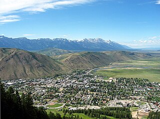
Jackson is a town in Teton County, Wyoming, United States. The population was 10,760 at the 2020 census, up from 9,577 in 2010. It is the largest town in Teton County and its county seat. Jackson is the principal town of the Jackson, WY-ID Micropolitan Statistical Area, which includes Teton County in Wyoming and Teton County in Idaho. The town, often familiarly or mistakenly called Jackson Hole, derives its name from the valley in which it is located. Jackson is a popular tourist destination due to its proximity to the ski resorts Jackson Hole Mountain, Snow King Mountain, and Grand Targhee, as well as Grand Teton National Park and Yellowstone National Park.

<span class="mw-page-title-main">Roadkill</span> Animals that have died due to vehicular incursions

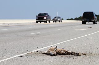
Roadkill is an animal or animals that have been struck and killed by drivers of motor vehicles. Wildlife-vehicle collisions (WVC) have increasingly been the topic of academic research to understand the causes, and how it can be mitigated.

<span class="mw-page-title-main">Jackson Hole</span> Valley in Wyoming, USA

Jackson Hole is a valley between the Gros Ventre and Teton mountain ranges in the U.S. state of Wyoming, near the border with Idaho, in Teton County. The term "hole" was used by early trappers, or mountain men, as a term for a large mountain valley. These low-lying valleys, surrounded by mountains and containing rivers and streams, are good habitat for beavers and other fur-bearing animals. Jackson Hole is 55 miles (89 km) long by 6-to-13 miles (10-to-21 km) wide and is a graben valley with an average elevation of 6,800 ft, its lowest point being near the southern park boundary at 6,350 ft.

<span class="mw-page-title-main">Mule deer</span> Deer indigenous to western North America

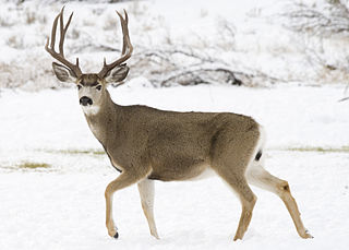
The mule deer is a deer indigenous to western North America; it is named for its ears, which are large like those of the mule. Two subspecies of mule deer are grouped into the black-tailed deer.

<span class="mw-page-title-main">Wildlife crossing</span> Structures enabling wildlife to safely cross human-made barriers

Wildlife crossings are structures that allow animals to cross human-made barriers safely. Wildlife crossings may include underpass tunnels or wildlife tunnels, viaducts, and overpasses or green bridges ; amphibian tunnels; fish ladders; canopy bridges ; tunnels and culverts ; and green roofs.

<span class="mw-page-title-main">Caribou–Targhee National Forest</span> Protected area in the U.S. states of Wyoming, Idaho, and Utah

Caribou–Targhee National Forest is located in the states of Idaho and Wyoming, with a small section in Utah in the United States. The forest is broken into several separate sections and extends over 2.63 million acres (10,600 km2). To the east the forest borders Yellowstone National Park, Grand Teton National Park and Bridger–Teton National Forest. Most of the forest is a part of the 20-million-acre (81,000 km2) Greater Yellowstone Ecosystem.

<span class="mw-page-title-main">National Elk Refuge</span>

The National Elk Refuge is a Wildlife Refuge located in Jackson Hole in the U.S. state of Wyoming. It was created in 1912 to protect habitat and provide sanctuary for one of the largest elk herds. With a total of 24,700 acres (10,000 ha), the refuge borders the town of Jackson, Wyoming on the southwest, Bridger-Teton National Forest on the east and Grand Teton National Park on the north. It is home to an average of 7,500 elk each winter. The refuge is managed by the U.S. Fish and Wildlife Service, an agency of the U.S. Department of the Interior.

<span class="mw-page-title-main">Subway (underpass)</span> Underpass for pedestrians and cycles

A subway, also known as an underpass, is a grade-separated pedestrian crossing which crosses underneath a road or railway in order to entirely separate pedestrians and cyclists from motor traffic or trains respectively.

<span class="mw-page-title-main">Railroad ecology</span>

Railroad ecology or railway ecology is a term used to refer to the study of the ecological community growing along railroad or railway tracks and the effects of railroads on natural ecosystems. Such ecosystems have been studied primarily in Europe. Similar conditions and effects appear also by roads used by vehicles. Railroads along with roads, canals, and power lines are examples of linear infrastructure intrusions.

<span class="mw-page-title-main">National Museum of Wildlife Art</span>

The National Museum of Wildlife Art (NMWA) is a museum located in Jackson Hole, Wyoming, United States that preserves and exhibits wildlife art. The 51,000 square foot building with its Idaho quartzite façade was inspired by the ruins of Slains Castle in Aberdeenshire, Scotland and echoes the hillside behind the facility. Located on a bluff called East Gros Ventre Butte in the midst of a real wildlife habitat, the institution overlooks the National Elk Refuge and is situated 2.5 miles north of the town of Jackson. The core of the collections reflects traditional and contemporary realism. The museum's centerpiece is a collection of works by Carl Rungius (1869–1959) and Bob Kuhn (1920–2007). In addition to 14 galleries, the museum has a sculpture trail, museum shop, restaurant, children's discovery gallery, and library. More than 80,000 people visit every year, and over 10,000 children visit the museum each year, often as part of their school curricula. The Museum is a nonprofit.

<span class="mw-page-title-main">Moose–Wilson Road</span>

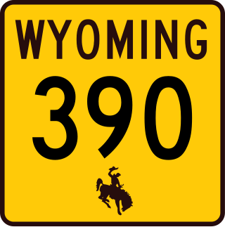
Moose–Wilson Road is a road in the U.S. state of Wyoming; the southern The 7.70 miles (12.39 km) of the road outside of Grand Teton National Park is Wyoming Highway 390 (WYO 390). The road runs about 15 miles (24 km) through the Jackson Hole valley from its intersection with WYO 22 east of Wilson on the south to Moose in Grand Teton National Park on the north end.

<span class="mw-page-title-main">Moose, Wyoming</span> Unincorporated community in Wyoming, United States

Moose is an unincorporated community in Teton County, Wyoming, in the Jackson Hole valley. It has a US Post Office, with the zip code of 83012. The town is located within Grand Teton National Park along the banks of the Snake River. It is populated mostly by families with inholdings within the borders of the park.

<span class="mw-page-title-main">Murie Ranch Historic District</span> Historic district in Wyoming, United States

The Murie Ranch Historic District, also known as the STS Dude Ranch and Stella Woodbury Summer Home is an inholding in Grand Teton National Park near Moose, Wyoming. The district is chiefly significant for its association with the conservationists Olaus Murie, his wife Margaret (Mardy) Murie and scientist Adolph Murie and his wife Louise. Olaus and Adolph Murie were influential in the establishment of an ecological approach to wildlife management, while Mardy Murie was influential because of her huge conservation victories such as passing the Alaska National Interest Lands Conservation Act of 1980 and being awarded with the highest civilian honor, the Presidential Medal of Freedom, for her lifetime works in conservation. Olaus Murie was a prominent early field biologist in the U.S. Biological Survey and subsequent U.S. Fish and Wildlife Service before retiring and becoming the president of the Wilderness Society, He was a prominent advocate for the preservation of wild lands in America.

<span class="mw-page-title-main">Olaus Murie</span> American naturalist and author

Olaus Johan Murie, called the "father of modern elk management", was a naturalist, author, and wildlife biologist who did groundbreaking field research on a variety of large northern mammals. Rather than conducting empirical experiments, Murie practiced a more observational-based science.

Road ecology is the study of the ecological effects of roads and highways. These effects may include local effects, such as on noise, water pollution, habitat destruction/disturbance and local air quality; and the wider environmental effects of transport such as habitat fragmentation, ecosystem degradation, and climate change from vehicle emissions.

<span class="mw-page-title-main">Road barrier effect</span> The effect that roads and railways have on the movement of wildlife

The barrier effect of roads and highways is a phenomenon usually associated with landscape ecology, referring to the barrier that linear infrastructure like roads or railways place on the movement of animals. Largely viewed as a negative process, the barrier effect has also been found to have several positive effects, particularly with smaller species. To reduce a road or railway's barrier effect, wildlife crossings are regarded as one of the best mitigation options, ideally in combination with wildlife fencing. The barrier effect is closely linked to habitat fragmentation and road ecology.

<span class="mw-page-title-main">McArthur Lake Wildlife Corridor</span> Wildlife corridor in Idaho, U.S.

The McArthur Lake Wildlife Corridor (MLWC) is a wildlife corridor in northern Idaho, United States. It links the wilderness areas of the Selkirk and Cabinet mountains, and is used by species such as grizzly bears that move between these areas. It also provides a wintering area for deer and other ungulates. A highway and two railway lines run through the corridor, with a strip of side roads, buildings and fences along the highway. The highway section running through the corridor has high rates of vehicle collisions with wildlife. There is limited opportunity for creating safe wildlife crossings due to the difficult terrain. Conservation groups have been active in obtaining easements on timber land to prevent further development in the corridor while allowing sustainable forestry.

A roadkill hotspot or blackspot is an accumulation of roadkill along a given length of roadway with significantly more wildlife-vehicle collisions than expected to occur by chance, based on a normal distribution. Decision-makers can then authorize the construction of roadkill mitigation infrastructure based on roadkill hotspot locations, prioritizing those with the most roadkill in number or those for a particular target species for conservation. Roadkill hotspots vary spatially and temporally, depending on the scale, duration of monitoring, and both the species and season in question. They can be calculated using roadkill survey data; GPS coordinates of roadkill collected by researchers and highway maintenance personnel, or increasingly, civilian-reported data. Additionally, roadkill hotspots can be projected by using a model to ascertain probable locations; models typically use existing wildlife abundance, distribution, and mitigation data combined with landscape variables and climatic data. Models are often used to determine the probable roadkill locations of ecologically sensitive animals or during the planning stages of a new road, it is noted that these locations may not align perfectly with sites of highest animal crossing attempts. Many academics stress the combined value of animal abundance and migration data with roadkill hotspots as a more assured way to ascertain the best locations to construct roadkill mitigation structures.

References

  1. United States Fish and Wildlife Service (August 1, 2019). "Seasons of Wildlife". National Wildlife Refuge, WY.
  2. 1 2 "Teton County Wildlife–Vehicle Collision Database Summary Report 2017/2018" (PDF). Jackson Hole Wildlife Foundation. February 2019.
  3. 1 2 3 4 5 6 7 8 9 10 11 12 13 14 15 "Teton County Wildlife Crossing Master Plan". Teton County Wildlife Crossings Master Plan. May 31, 2018.
  4. "In Wyoming, A Solution To Wildlife Traffic Accidents". Science Friday. Retrieved August 1, 2019.
  5. "Where do animals get hit? Wildlife-vehicle collisions mapped statewide". Buckrail. May 13, 2019. Retrieved August 1, 2019.
  6. "Animal-vehicle collisions more common in Wyoming". The Sheridan Press. December 1, 2018. Retrieved August 1, 2019.
  7. "Wildlife collisions cost Teton county $1.2M per year". The Billings Gazette. Retrieved August 2, 2019.
  8. "Give Wildlife a Brake". Jackson Hole Wildlife Foundation. Retrieved August 3, 2019.
  9. "Safer Crossings". The Nature Conservancy. Retrieved August 1, 2019.
  10. Resources, National Research Council Committee on Agricultural Land Use and Wildlife (1970). Wildlife Values in a Changing World. National Academies Press.
  11. Zuercher, Gerald L. (September 2004). "Wildlife, Conservation, and Human Welfare: A United States and Canadian Perspective". Wildlife Society Bulletin. 32 (3): 1007–1008. doi:10.2193/0091-7648(2004)032[1007:wcahwa]2.0.co;2. ISSN   0091-7648. S2CID   88103691.
  12. Clevenger, Anthony (2005). "Conservation Value of Wildlife Crossings: Measures of Performance and Research Directions" (PDF). Oekom.de/gaia.
  13. Koshmrl, Mike (July 3, 2019). "How will the moose cross the road?". Jackson Hole News&Guide. Retrieved August 2, 2019.
  14. 1 2 Zamesnik, Leah; Colligan, Chris; Mobeck, Jon (June 12, 2019). "Let's build wildlife crossings so Jackson Hole moose can cross the highway". Guest Shot. Jackson Hole News&Guide. Retrieved August 2, 2019.
  15. Bissonette, John A.; Cramer, P. C. (August 29, 2005). "Wildlife crossings in North America: the state of the science and practice".{{cite journal}}: Cite journal requires |journal= (help)
  16. 1 2 "Teton County Wildlife Crossings Master Plan Action Summary". Teton County Wyoming. May 1, 2018.
  17. Grift, Edgar A. van der; Ree, Rodney van der; Houlahan, Jeff; Findlay, C. Scott; Fahrig, Lenore; Jaeger, Jochen A. G.; Soanes, Kylie; Rytwinski, Trina (November 21, 2016). "How Effective Is Road Mitigation at Reducing Road-Kill? A Meta-Analysis". PLOS ONE. 11 (11): e0166941. Bibcode:2016PLoSO..1166941R. doi: 10.1371/journal.pone.0166941 . ISSN   1932-6203. PMC   5117745 . PMID   27870889.
  18. "Teton County Wildlife Crossings Master Plan Action Summary". Teton County Wyoming.
  19. Seidler, Renee G.; Green, David S.; Beckmann, Jon P. (July 1, 2018). "Highways, crossing structures and risk: Behaviors of Greater Yellowstone pronghorn elucidate efficacy of road mitigation". Global Ecology and Conservation. 15: e00416. doi: 10.1016/j.gecco.2018.e00416 . ISSN   2351-9894.
  20. Mccollister, Matthew F.; Manen, Frank T. Van (2010). "Effectiveness of Wildlife Underpasses and Fencing to Reduce Wildlife-Vehicle Collisions". The Journal of Wildlife Management. 74 (8): 1722–1731. Bibcode:2010JWMan..74.1722M. doi:10.2193/2009-535. ISSN   1937-2817. S2CID   86709243.
  21. Huijser, Marcel P.; Fairbank, Elizabeth R.; Camel-Means, Whisper; Graham, Jonathan; Watson, Vicki; Basting, Pat; Becker, Dale (May 1, 2016). "Effectiveness of short sections of wildlife fencing and crossing structures along highways in reducing wildlife–vehicle collisions and providing safe crossing opportunities for large mammals". Biological Conservation. 197: 61–68. Bibcode:2016BCons.197...61H. doi:10.1016/j.biocon.2016.02.002. ISSN   0006-3207.
  22. "Teton County adopts Wildlife Crossing Master Plan!". Greater Yellowstone Coalition. Retrieved August 2, 2019.
  23. Sawyer, Hall; Rodgers, Patrick (September 2015). "Welcome to ROSA P | Pronghorn and Mule Deer Use of Underpasses and Overpasses Along US Highway 191, Wyoming - 34368 | US Transportation Collection". rosap.ntl.bts.gov. Retrieved August 3, 2019.
  24. Koshmrl, Mike (July 3, 2019). "How will the moose cross the road?" . Jackson Hole News&Guide. Archived from the original on July 6, 2019. Retrieved November 22, 2019.
  25. Cottier, Cody (June 12, 2019). "Teton County wildlife crossings dominate SPET hearing". Jackson Hole News&Guide. Retrieved August 3, 2019.
  26. 1 2 Gross, Allie (July 17, 2019). "10 SPET projects won't be bundled". Jackson Hole News&Guide. Retrieved August 3, 2019.