Prosperity, West Virginia

Last updated

Prosperity, West Virginia
WVMap-doton-Prosperity.PNG
Location of Prosperity, West Virginia
Coordinates: 37°50′19″N81°11′55″W / 37.83861°N 81.19861°W / 37.83861; -81.19861
Country United States
State West Virginia
County Raleigh
Area
[1]
  Total2.5 sq mi (6.4 km2)
  Land2.5 sq mi (6.4 km2)
  Water0.0 sq mi (0.0 km2)
Elevation
[2]
2,451 ft (747 m)
Population
 (2010) [3]
  Total1,498
  Density600/sq mi (230/km2)
Time zone UTC-5 (Eastern (EST))
  Summer (DST) UTC-4 (EDT)
ZIP code
25909
Area code 304
FIPS code 54-65836 [4]
GNIS feature ID2389712 [2]

Prosperity is a census-designated place (CDP) in Raleigh County, West Virginia, United States. The population was 1,498 at the 2010 census. [3]

Contents

Geography

According to the United States Census Bureau, the CDP has a total area of 2.5 square miles (6.4 km2), all land.

Demographics

At the 2000 census there were 1,310 people, 570 households, and 395 families living in the CDP. The population density was 840.6 people per square mile (324.2/km2). There were 624 housing units at an average density of 400.4/sq mi (154.4/km2). The racial makeup of the CDP was 98.24% White, 0.92% African American, 0.15% Native American, 0.15% Asian, and 0.53% from two or more races. Hispanic or Latino of any race were 0.53%. [4]

Of the 570 households 27.2% had children under the age of 18 living with them, 54.6% were married couples living together, 11.2% had a female householder with no husband present, and 30.7% were non-families. 28.2% of households were one person and 12.5% were one person aged 65 or older. The average household size was 2.30 and the average family size was 2.81.

The age distribution was 20.5% under the age of 18, 8.3% from 18 to 24, 29.4% from 25 to 44, 27.3% from 45 to 64, and 14.6% 65 or older. The median age was 40 years. For every 100 females, there were 88.5 males. For every 100 females age 18 and over, there were 87.1 males.

The median household income was $31,632 and the median family income was $50,306. Males had a median income of $35,063 versus $26,513 for females. The per capita income for the CDP was $19,552. About 5.6% of families and 6.7% of the population were below the poverty line, including 13.7% of those under age 18 and 5.0% of those age 65 or over.

Related Research Articles

<span class="mw-page-title-main">Rock Creek, Alabama</span> CDP in Alabama, United States

Rock Creek is a census-designated place in Jefferson County, Alabama, United States. Its location is northwest of Hueytown. At the 2020 census, the population was 1,471. This area was damaged by an F5 tornado on April 8, 1998. An EF2 tornado struck northwest from here on January 23, 2012.

<span class="mw-page-title-main">Noatak, Alaska</span> Place in Alaska, United States

Noatak is a census-designated place (CDP) in the Northwest Arctic Borough in the U.S. state of Alaska. The population was 570 at the 2020 census, up from 514 in 2010. It is served by Noatak Airport.

<span class="mw-page-title-main">Gisela, Arizona</span> CDP in Gila County, Arizona

Gisela is an unincorporated community and census-designated place (CDP) in Gila County, Arizona, United States. The population was 570 at the 2010 census.

<span class="mw-page-title-main">Big River, California</span> Census-designated place in California, United States

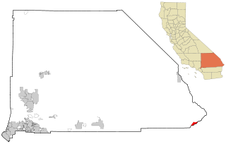
Big River is a census-designated place (CDP) in San Bernardino County, California, United States. The population was 1,084 at the 2020 census, down from 1,327 at the 2010 census.

<span class="mw-page-title-main">Pepeekeo, Hawaii</span> Census-designated place in Hawaii, U.S.

Pepeekeo is a census-designated place (CDP) in Hawaii County, Hawaii, United States. The population was 1,789 at the 2010 census, up from 1,697 at the 2000 census.

Long Lake is an unincorporated community and census-designated place (CDP) in Lake County, Illinois, United States. Per the 2020 census, the population was 3,663.

<span class="mw-page-title-main">Taylorsville, Indiana</span> CDP in Indiana, United States

Taylorsville is a census-designated place (CDP) in German Township, Bartholomew County, in the U.S. state of Indiana. The population was 919 at the 2010 census. It is part of the Columbus, Indiana metropolitan statistical area.

<span class="mw-page-title-main">Memphis, Indiana</span> CDP in Indiana, United States

Memphis is a census-designated place (CDP) in Clark County, Indiana, United States. The population was 695 at the 2010 census.

<span class="mw-page-title-main">Simonton Lake, Indiana</span> Census-designated place in Indiana, United States

Simonton Lake is a census-designated place (CDP) in Elkhart County, Indiana, United States. The population was 4,678 at the 2010 census.

Wallace is a census-designated place (CDP) in St. John the Baptist Parish, Louisiana, United States. The population was 570 at the 2000 census. It is part of the New Orleans–Metairie–Kenner Metropolitan Statistical Area. The rural community is on the west bank of the Mississippi River and easily accessible to Interstate 10 via the Gramercy Bridge.

<span class="mw-page-title-main">Millis-Clicquot, Massachusetts</span> CDP in Massachusetts, United States

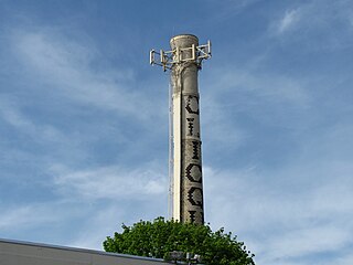
Millis-Clicquot is a census-designated place (CDP) in the town of Millis in Norfolk County, Massachusetts, United States. The population was 4,403 at the 2010 census. The name "Clicquot" comes from the now-defunct Clicquot Club Company, a beverage manufacturer that was founded in the area in 1881.

<span class="mw-page-title-main">Barclay-Kingston, New Jersey</span> Populated place in Camden County, New Jersey, US

Barclay-Kingston is an unincorporated community and former census-designated place (CDP) located within Cherry Hill Township, in Camden County, in the U.S. state of New Jersey. As of the 2000 United States Census, the section population was 10,728. In the 2010 United States Census, the Barclay-Kingston CDP was split into two new CDPs, Barclay and Kingston Estates.

<span class="mw-page-title-main">Lake Telemark, New Jersey</span> Populated place in Morris County, New Jersey, US

Lake Telemark is an unincorporated community and census-designated place (CDP) located within Rockaway Township, in Morris County, in the U.S. state of New Jersey. As of the 2010 United States Census, the CDP's population was 1,255.

<span class="mw-page-title-main">Northampton, Suffolk County, New York</span> Hamlet and census-designated place in New York, United States

Northampton is a hamlet and census-designated place (CDP) in Suffolk County, New York, United States on Long Island. The CDP population was 570 at the 2010 census.

<span class="mw-page-title-main">Forestville, Ohio</span> Census-designated place in Ohio, United States

Forestville is a census-designated place (CDP) in Hamilton County, Ohio, United States. The population was 10,615 at the 2020 census.

<span class="mw-page-title-main">Fruit Hill, Ohio</span> Census-designated place in Ohio, United States

Fruit Hill is a census-designated place (CDP) in Hamilton County, Ohio, United States. The population was 3,748 at the 2020 census.

<span class="mw-page-title-main">Northgate, Ohio</span> Census-designated place in Ohio, United States

Northgate is a census-designated place (CDP) in Colerain Township, Hamilton County, Ohio, United States. The population was 7,277 at the 2020 census.

<span class="mw-page-title-main">Loveland Park, Ohio</span> Census-designated place in Ohio, United States

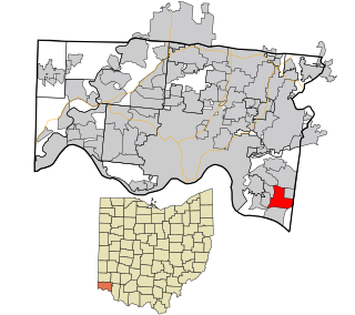
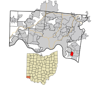
Loveland Park is a census-designated place (CDP) located in Symmes Township, Hamilton County and Deerfield Township, Warren County, in the southwestern part of the U.S. state of Ohio. The CDP is named after the city of Loveland. The population was 1,737 at the 2020 census.

<span class="mw-page-title-main">Milton (CDP), Vermont</span> Census-designated place in Vermont, United States

Milton is an unincorporated village within the town of Milton in Chittenden County, Vermont, United States. The village disincorporated in 2003 and became a census-designated place (CDP) in 2008. As of the 2020 census the population was 3,804, out of a population of 10,723 for the entire town.

<span class="mw-page-title-main">Skyline Acres, Ohio</span> Census-designated place in Ohio, United States

Skyline Acres is a census-designated place (CDP) in Colerain and Springfield townships, Hamilton County, Ohio, United States. The population was 1,446 at the 2020 census.

References

  1. "US Gazetteer files: 2010, 2000, and 1990". United States Census Bureau. February 12, 2011. Retrieved April 23, 2011.
  2. 1 2 U.S. Geological Survey Geographic Names Information System: Prosperity, West Virginia
  3. 1 2 "U.S. Census website". United States Census Bureau . Retrieved May 14, 2011.
  4. 1 2 "U.S. Census website". United States Census Bureau . Retrieved January 31, 2008.