
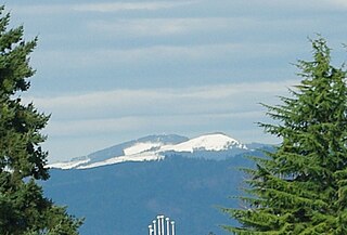
Mount Hood, called Wy'east by the Multnomah tribe, is a potentially active stratovolcano in the Cascade Volcanic Arc. It was formed by a subduction zone on the Pacific coast and rests in the Pacific Northwest region of the United States. It is located about 50 miles (80 km) east-southeast of Portland, on the border between Clackamas and Hood River counties. In addition to being Oregon's highest mountain, it is one of the loftiest mountains in the nation based on its prominence.

The Alsea River flows 48.5 miles (78.1 km) from Alsea, an unincorporated community in the coastal mountains of the U.S. state of Oregon, to the Pacific Ocean near the city of Waldport. It begins at the confluence of the North Fork Alsea River and the South Fork Alsea River and ends in Alsea Bay, a wide estuary at Waldport. The river flows generally west-northwest in a winding course through the mountains of southern Benton and Lincoln counties, passing near the unincorporated community of Tidewater and through the Siuslaw National Forest. Its drainage basin extends into Lane County, along the headwaters of the South Fork Alsea River.

The Grande Ronde River is a tributary of the Snake River, 182 miles (293 km) long, in northeastern Oregon and southeastern Washington in the United States. It drains an area southeast of the Blue Mountains and northwest of the Wallowa Mountains, on the Columbia Plateau. It flows through the agricultural Grande Ronde Valley in its middle course and through a series of scenic canyons in its lower course.

Steens Mountain is in the southeastern part of the U.S. state of Oregon, and is a large fault-block mountain, Located in Harney County, it stretches some 50 miles (80 km) north to south, and rises from alongside the Alvord Desert at elevation of about 4,200 feet (1,300 m) to a summit elevation of 9,733 feet (2,967 m). It is sometimes confused with a mountain range but is properly a single mountain.

Wheeler Peak is the highest natural point in the U.S. state of New Mexico. It is located northeast of Taos and south of Red River in the northern part of the state, and just 2 miles (3.2 km) southeast of the ski slopes of Taos Ski Valley. It lies in the Sangre de Cristo Mountains, the southernmost subrange of the Rocky Mountains. The peak's elevation is 13,167 feet (4,013 m).
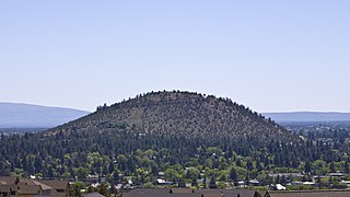
Pilot Butte is a lava dome that was created from an extinct volcano located in Bend, Oregon. It is a cinder cone butte which rises nearly 500 feet (150 m) above the surrounding plains. Bend is one of four cities in the United States to have a volcano within its boundaries. Portland is the only other city in Oregon with a volcano within its city limits, with Mount Tabor. Jackson Volcano in Jackson, Mississippi, and Diamond Head in Honolulu are the others.

Hart Mountain is a fault-block mountain, in Lake County, Oregon, U.S. It lies about 30 miles (48 km) to the east of Lakeview.

Maiden Peak is a steep-sided shield volcano in the Cascade Range of central Oregon. It is the highest point in the 43-mile (69 km) distance between Mount Bachelor and Diamond Peak. Ice Age glaciers carved a large cirque into the northeast flank of the mountain, exposing magma which hardened in the volcano's conduits to form the numerous rock pinnacles now found in the upper part of the cirque.

Yamsay Mountain is a large shield volcano in the Cascade Range of south-central Oregon, located about 35 miles (56 km) east of Crater Lake on the border between Klamath County and Lake County. It is part of the Cascade Volcanic Arc but is located in a mountain range 30 to 50 miles behind the main Cascade volcanic front. The best known members of this enigmatic arc are the massive shields of Newberry Volcano, about 55 miles (89 km) farther north in Oregon, and Medicine Lake Volcano, about 80 miles (130 km) south in Northern California. Yamsay is the highest volcano in the eastern arc, almost 300 feet (90 m) higher than Newberry and Medicine Lake.

Saddle Mountain is the tallest mountain in Clatsop County in the U.S. state of Oregon. Part of the Oregon Coast Range, Saddle Mountain is in Saddle Mountain State Natural Area in the northwest corner of Oregon. The peak is listed on Oregon’s Register of Natural Heritage Resources.
South Saddle Mountain is the tallest mountain in Washington County, Oregon, United States. Part of the Oregon Coast Range, the peak is located in the Tillamook State Forest in the northwest section of the state of Oregon. It is the eighth-highest peak of the Oregon Coast Range.

Tom Dick and Harry Mountain is a two-mile-long volcanic mountain in Clackamas County in the U.S. state of Oregon. It is located 7.2 miles (11.6 km) southwest of Mount Hood, 1.9 miles (3.1 km) west-southwest of Government Camp between the Zigzag River and Still Creek, south of Zigzag Mountain. Because of its proximity to Mount Hood, it is considered a foothill.

Alvord Lake is a seasonal shallow alkali lake in Harney County of the U.S. state of Oregon. Its elevation is 4,026 feet (1,227 m). It is located about 10 miles (16 km) southeast of Alvord Desert in the Alvord Basin and serves as terminus for all its streams. Its water level varies from dry to several feet deep. The nearest habitation is tiny Fields, 14.1 kilometres (8.8 mi) SSW.
Mount Ireland is a mountain in Grant County of the U.S. state of Oregon. It is about 5 miles (8 km) east-northeast of Granite, Oregon. It is the second highest peak in the Blue Mountains at 8,325 feet (2,537 m) after Strawberry Mountain, and Oregon's 71st highest peak. For a period of several years, this mountain peak was referred to as Bald Mountain but in 1975, it was changed to Ireland Mountain before formally becoming known as Mount Ireland. The name change was brought about by a cooperative effort of local citizens and the US Forest Service to honor Henry Ireland, a forest supervisor for many years, who had died in 1916.

The Trout Creek Mountains are a remote, semi-arid Great Basin mountain range mostly in southeastern Oregon and partially in northern Nevada in the United States. The range's highest point is Orevada View Benchmark, 8,506 feet (2,593 m) above sea level, in Nevada. Disaster Peak, elevation 7,781 feet (2,372 m), is another prominent summit in the Nevada portion of the mountains.
Sacajawea Peak is a peak in the Wallowa Mountains, in the U.S. state of Oregon. It is in the Eagle Cap Wilderness and the Wallowa–Whitman National Forest.

Mount Ashland is the highest peak in the Siskiyou Mountains of southern Oregon. It was named for the city of Ashland, located 8.6 miles (14 km) north of the mountain. The Siskiyou Mountains are a subrange of the Klamath Mountains in northwestern California and southwestern Oregon. The mountain is part of the Rogue River–Siskiyou National Forest, which encompasses most of the Siskiyou Mountains. The Oregon–California border is 5 miles (8 km) south of the mountain.

The Jemez River is a tributary of the Rio Grande in the U.S. state of New Mexico. The river is formed by the confluence of the East Fork Jemez River and San Antonio Creek, which drain a number of tributaries in the area of the Jemez Mountains and Santa Fe National Forest. The Jemez River is about 50 miles (80 km) long, or about 80 miles (130 km) long if its longest headwater tributary, San Antonio Creek, is included. The East Fork Jemez River is about 22 miles (35 km) long. Both San Antonio Creek and the East Fork Jemez River flow through intricate meanders along their courses. The East Fork Jemez is a National Wild and Scenic River.
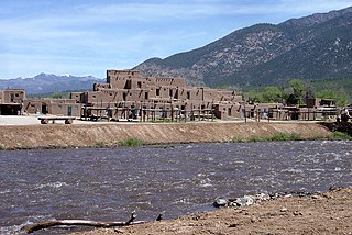
The Rio Pueblo de Taos, also known as Rio Pueblo, is a tributary of the Rio Grande in the U.S. state of New Mexico. From its source in the Sangre de Cristo Mountains it flows about 33 miles (53 km), generally south and west, to join the Rio Grande in the Rio Grande Gorge. On the way the river passes by Taos and through Taos Pueblo.


