Purple Peak (Colorado)

Last updated
Purple Peak
Purple Peak.jpg
North aspect in winter
Highest point
Elevation 12,800 ft (3,901 m) [1] [2]
Prominence 160 ft (49 m) [3]
Parent peak Mount Owen (13,070 ft) [3]
Isolation 0.31 mi (0.50 km) [2]
Coordinates 38°54′45″N107°07′13″W / 38.9125799°N 107.1202953°W / 38.9125799; -107.1202953 [4]
Geography
USA Colorado relief location map.svg
Red triangle with thick white border.svg
Purple Peak
Location in Colorado
Usa edcp relief location map.png
Red triangle with thick white border.svg
Purple Peak
Purple Peak (the United States)
CountryUnited States
State Colorado
County Gunnison County
Protected area Raggeds Wilderness
Parent range Rocky Mountains
Elk Mountains
Ruby Range [1]
Topo map USGS Oh-be-joyful
Climbing
Easiest route class 2 hiking [3]

Purple Peak is a mountain summit in Gunnison County, Colorado, United States.

Contents

Description

Purple Peak, elevation 12,800-feet (3,901 m), is situated in the Elk Mountains which are a subrange of the Rocky Mountains. [2] The peak is located nine miles (14 km) northwest of the community of Crested Butte in the Raggeds Wilderness on land managed by Gunnison National Forest. It is set on the crest of the Ruby Range between Afley Peak to the north and line parent Mount Owen to the southwest. Precipitation runoff from the mountain's northeast slope drains into Oh-be-joyful Creek which is a tributary of the Slate River, and the west and south slopes drain into Silver Creek and Ruby Anthracite Creek, thence North Fork Gunnison River. Topographic relief is significant as the summit rises 1,760 feet (536 m) above Blue Lake in one-half mile (0.80 km). The landform's toponym was officially adopted in 1965 by the United States Board on Geographic Names. [5] This landform should not be confused with Purple Mountain, five miles to the north.

North aspect of Purple Peak viewed from Afley Peak. Top of Mt. Owen in upper right corner. Purple Peak, Colorado.jpg
North aspect of Purple Peak viewed from Afley Peak. Top of Mt. Owen in upper right corner.

Climate

According to the Köppen climate classification system, Purple Peak is located in an alpine subarctic climate zone with cold, snowy winters, and cool to warm summers. [6] Due to its altitude, it receives precipitation all year, as snow in winter, and as thunderstorms in summer, with a dry period in late spring.

See also

Related Research Articles

<span class="mw-page-title-main">Sharkstooth Peak</span>

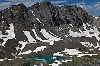
Sharkstooth Peak is a 12,468-foot-elevation (3,800-meter) mountain summit in Montezuma County, Colorado.

<span class="mw-page-title-main">Powell Peak</span> Mountain in Colorado, United States of America

Powell Peak is a summit in Grand County, Colorado, in the United States. With an elevation of 13,176 feet (4,016 m), Powell Peak is the 493rd-highest summit in the state of Colorado.

<span class="mw-page-title-main">Mears Peak</span> Mountain in the state of Colorado

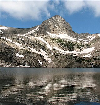
Mears Peak is a 13,496-foot-elevation (4,114-meter) mountain summit located on the common boundary of Ouray County with San Miguel County, in Colorado, United States. It is situated six miles northwest of the community of Telluride, in the Mount Sneffels Wilderness, on land managed by Uncompahgre National Forest. It is part of the Sneffels Range which is a subset of the San Juan Mountains, which in turn is part of the Rocky Mountains. Mears Peak is situated west of the Continental Divide, and 3.8 miles west of Mount Sneffels. Topographic relief is significant as the south aspect rises 4,900 feet above the San Miguel River in approximately 5.5 miles.

<span class="mw-page-title-main">American Peak</span>

American Peak is a 13,806-foot-elevation (4,208-meter) mountain summit located in Hinsdale County, of southwest Colorado, United States.

<span class="mw-page-title-main">Twining Peak</span>

Twining Peak is a 13,711-foot (4,179 m) mountain summit on the shared border of Pitkin County and Lake County, in Colorado, United States.

<span class="mw-page-title-main">Star Peak (Colorado)</span>

Star Peak is a 13,527-foot (4,123 m) summit on the shared border between Gunnison County and Pitkin County in Colorado, United States.

<span class="mw-page-title-main">The Castles (Colorado)</span> Geological formation in Colorado, US

The Castles are pillars in Gunnison County, Colorado, United States.

<span class="mw-page-title-main">Afley Peak</span> Mountain in the state of Colorado

Afley Peak is a mountain summit in Gunnison County, Colorado, United States.

<span class="mw-page-title-main">Carson Peak (Colorado)</span> Mountain in the state of Colorado

Carson Peak is a 13,662-foot-elevation (4,164-meter) summit in Hinsdale County, Colorado, United States.

<span class="mw-page-title-main">Purple Mountain (Colorado)</span> Mountain in the state of Colorado

Purple Mountain is a summit in Gunnison County, Colorado, United States.

<span class="mw-page-title-main">Mount Daly (Colorado)</span> Mountain in the state of Colorado

Mount Daly is a mountain summit in Pitkin County, Colorado, United States.

<span class="mw-page-title-main">Keefe Peak</span> Mountain in the state of Colorado

Keefe Peak is a 13,532-foot (4,125 m) mountain summit in Pitkin County, Colorado, United States.

<span class="mw-page-title-main">Mount Toll</span> Mountain in the state of Colorado

Mount Toll is a 12,979-foot (3,956 m) mountain summit on the boundary shared by Boulder County and Grand County, in Colorado, United States.

<span class="mw-page-title-main">Centennial Peak (Colorado)</span> Mountain in the state of Colorado

Centennial Peak is a 13,062-foot-elevation (3,981-meter) mountain summit in Montezuma County, Colorado.

<span class="mw-page-title-main">Taylor Peak (Gunnison County, Colorado)</span> Mountain in the state of Colorado

Taylor Peak is a 13,435-foot (4,095 m) summit on the boundary shared by Gunnison County and Pitkin County in Colorado, United States.

<span class="mw-page-title-main">Crystal Peak (Gunnison County, Colorado)</span>

Crystal Peak is a 12,777-foot (3,894 m) mountain summit in Gunnison County, Colorado, United States.

<span class="mw-page-title-main">Emma Burr Mountain</span> Mountain in the state of Colorado

Emma Burr Mountain is a 13,544-foot-elevation (4,128-meter) mountain summit on the common border shared by Chaffee and Gunnison counties in Colorado, United States.

<span class="mw-page-title-main">Grizzly Peak (Gunnison County, Colorado)</span> Mountain in the state of Colorado

Grizzly Peak is a 13,309-foot-elevation (4,057-meter) mountain summit in Gunnison County, Colorado, United States.

<span class="mw-page-title-main">Pearl Mountain</span> Mountain in the state of Colorado

Pearl Mountain is a 13,379-foot (4,078 m) summit on the shared border between Gunnison County and Pitkin County in Colorado, United States.

<span class="mw-page-title-main">Sleeping Sexton</span>

Sleeping Sexton is a 13,457-foot (4,102 m) mountain ridge in Pitkin County, Colorado, United States.

References

  1. 1 2 Scott Warren (2002), Exploring Colorado's Wild Areas, Mountaineers Books, ISBN   9780898867848, p. 139.
  2. 1 2 3 "Purple Peak, Colorado". Peakbagger.com. Retrieved April 15, 2023.
  3. 1 2 3 "Purple Peak - 12,820' CO". listsofjohn.com. Retrieved April 15, 2023.
  4. "Purple Peak". Geographic Names Information System . United States Geological Survey, United States Department of the Interior . Retrieved April 15, 2023.
  5. Decisions on Geographic Names in the United States, Decision List 6501, (1965), United States Board on Geographic Names, Department of the Interior, p. 20.
  6. Peel, M. C.; Finlayson, B. L.; McMahon, T. A. (2007). "Updated world map of the Köppen−Geiger climate classification". Hydrol. Earth Syst. Sci. 11. ISSN   1027-5606.