
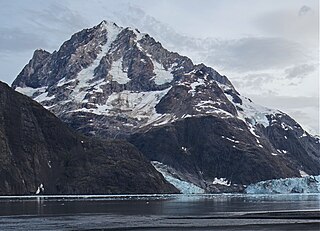
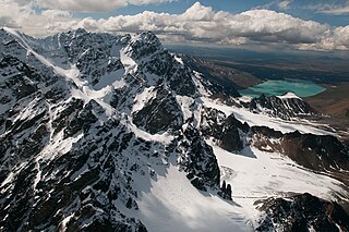
Mount Foresta is an 11,000+ ft multi-peak massif located in Wrangell–St. Elias National Park, in the Saint Elias Mountains of Alaska in the United States. Rising high above the lower western margin of the Hubbard Glacier, the summit of Mount Foresta is just over nine miles (14 km) from tidewater at Disenchantment Bay, 12 mi (19 km) northwest of Mount Seattle, 14.5 mi (23 km) southeast of Mount Vancouver, and 46 mi (74 km) north of Yakutat.
Mount Abbe is an 8200+ feet double summit mountain located in the Fairweather Range of the Saint Elias Mountains, in southeast Alaska. The peak is situated near the terminus of the Johns Hopkins Glacier, within Glacier Bay National Park and Preserve, 100 mi (161 km) northwest of Juneau, and 8.2 mi (13 km) northeast of Mount Orville. Although modest in elevation, relief is significant since the mountain rises up from tidewater in less than two miles. Mount Abbe is often seen and photographed with the Johns Hopkins Glacier, which is a popular destination for cruise ships. The mountain was named in 1936 by William Osgood Field and William Skinner Cooper, of the American Geographical Society, for Cleveland Abbe Jr., (1872-1934), an American geographer. Abbe received a Ph.D. in 1898 from Johns Hopkins University. The Gilman Glacier and Clark Glacier on the mountain's slopes were named for Daniel Coit Gilman, the institution's first president, and William Bullock Clark who was a professor of geology at the university. The mountain's name was officially adopted in 1937 by the United States Geological Survey. The first ascent of the south summit was made June 11, 1977, by Jim Wickwire and Dusan Jagersky via the Southeast Face. Three days later, Dusan Jagersky was killed while descending an unnamed peak. The first ascent of the north summit was made July 14, 1991, by Walter Gove and William Pilling. The months May through June offer the most favorable weather for climbing Mount Abbe, but it's a challenging climb in any conditions, with few attempts.

Mount Cooper is a 6780-foot (2067-meter) mountain summit located in the Fairweather Range of the Saint Elias Mountains, in southeast Alaska. The peak is situated in Glacier Bay National Park and Preserve at the entrance to Johns Hopkins Inlet, 100 mi (161 km) northwest of Juneau, and 5.6 mi (9 km) northeast of Mount Abbe, which is the nearest higher peak. Although modest in elevation, relief is significant since the mountain rises up from tidewater in less than two miles. Mount Cooper can be seen from Johns Hopkins Inlet which is a popular destination for cruise ships. The mountain's name was proposed in the 1950s for William Skinner Cooper (1884-1978), a plant ecologist who performed vegetation-glacier relationship studies in the Glacier Bay area, and was chairman of the committee of scientists which proposed establishing Glacier Bay National Monument. The mountain's name was officially adopted in 1980 by the United States Geological Survey following Cooper's death. The months May through June offer the most favorable weather for climbing Mount Cooper.

Mount Merriam is a prominent 5,083-foot (1,549-meter) mountain summit located in Glacier Bay National Park and Preserve, in the Alsek Ranges of the Saint Elias Mountains, in southeast Alaska. The mountain is situated 75 mi (121 km) northwest of Juneau, 3.1 mi (5 km) south of Mount Wordie, 3.5 mi (6 km) north of Black Cap Mountain, and 13.4 mi (22 km) southeast of Mount Abdallah which is the nearest higher peak. Although modest in elevation, relief is significant as the mountain rises up from tidewater in less than three miles, and it ranks 85th in prominence for all peaks in Alaska.

Mount Wordie is a 4,700+ foot mountain summit located in Glacier Bay National Park and Preserve, in the Alsek Ranges of the Saint Elias Mountains, in southeast Alaska. The mountain is situated 80 mi (129 km) northwest of Juneau, 4 mi (6 km) south of Carroll Glacier, and 3.1 mi (5 km) north of Mount Merriam which is the nearest higher peak. Although modest in elevation, relief is significant as the mountain rises up from tidewater in less than two miles. Precipitation runoff from the mountain drains into Glacier Bay Basin. Weather permitting, Mount Wordie can be seen from Queen Inlet and Wachusett Inlet of Glacier Bay, which is a popular destination for cruise ships.

Black Peak is a prominent 6,385-foot (1,946-meter) glaciated mountain summit located in Lake Clark National Park and Preserve, in the Chigmit Mountains of the Aleutian Range, in the US state of Alaska. It is the second-highest non-volcanic peak in the Chigmit Mountains, and fourth-highest overall. The mountain is situated 22 mi (35 km) west of Cook Inlet, 90 mi (145 km) west-southwest of Anchorage, and 10.2 mi (16 km) northeast of Double Peak, which is the nearest higher peak. Although modest in elevation, relief is significant since the mountain rises up 6,200 feet from North Fork Big River in about two miles. The mountain's descriptive name was published in 1912 by the United States Coast and Geodetic Survey. The months May through June offer the most favorable weather for viewing or climbing the peak.

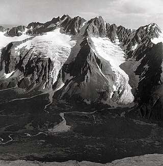
Pyramid Peak is an 8,875-foot (2,705-meter) mountain summit located at the western edge of the Saint Elias Mountains, in the U.S. state of Alaska. The peak is situated in Wrangell-St. Elias National Park and Preserve, 22 mi (35 km) southeast of McCarthy, 7 mi (11 km) southeast of Williams Peak, and 6 mi (10 km) south-southeast of Joshua Green Peak. The peak's descriptive local name was reported in 1908 by the United States Geological Survey. Precipitation runoff from the mountain drains into tributaries of the Nizina River, which in turn is part of the Copper River drainage basin.
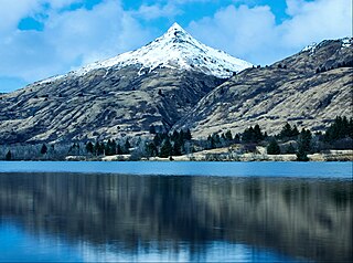
Pyramid Mountain is a 2,395-foot (730-meter) elevation mountain summit located on Kodiak Island in the US state of Alaska. The mountain is situated 7.5 mi (12 km) west of Kodiak. Although modest in elevation, relief is significant since the peak rises over 2,300 feet above Buskin Lake in only 1.5 mi (2 km). This peak's descriptive name was first published in 1943 by the United States Coast and Geodetic Survey.

Mount Ballyhoo is a 1,650-foot-elevation (503-meter) summit in Alaska, United States.

Mount Newhall is a 1,916-foot-elevation (584-meter) summit in Alaska, United States.
Icy Peak is a 4,550-foot-elevation (1,390-meter) mountain summit in Alaska, United States.

Mount Stepo is a 3,828-foot-elevation (1,167-meter) mountain summit in Alaska.

Mount Becharof is a 3,146-foot-elevation (959-meter) mountain summit in Alaska.
Eickelberg Peak is a 3,648-foot-elevation (1,112-meter) summit in Alaska, United States.

West Saint Peak is a 3,337-foot-elevation (1,017-meter) summit in Alaska.

Ch'akajabena Mountain is a 7,530-foot-elevation (2,295-meter) mountain summit in Alaska.
Telaquana Mountain is an 8,070-foot-elevation (2,460-meter) mountain summit in Alaska.

Mount Gakona is a 9,865-foot-elevation (3,007-meter) mountain summit in Alaska.

Pyramid Mountain is a 5,519-foot-elevation (1,682-meter) mountain summit in Alaska, United States.
Mount Fellows is a 4,476-foot-elevation (1,364-meter) mountain summit in Alaska, United States.


