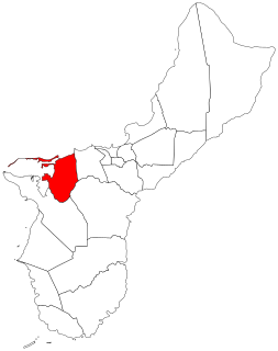
Piti is a village located on the central west coast of the United States territory of Guam. It contains northern and eastern coastlines of Apra Harbor, including Cabras Island, which has the commercial Port of Guam and the island's largest power plants. Piti was a pre-Spanish CHamoru village and, after Spanish colonization, became the primary port town on Guam. The town was largely destroyed during the 1944 liberation of Guam and the population relocated during the wartime construction of Apra Harbor.

The As Sombreru Pillbox I, As Sombreru Pillbox II, and As Sombreru Pillbox III are three historic defensive fortifications on Guam, near Tumon, that were listed on the U.S. National Register of Historic Places in 1991. They are pillboxes, a type of defensive fortification, built by the 48th Independent Mixed Brigade; 29th Division of the Imperial Japanese Army during 1941-1944, between Japan capturing Guam on December 8, 1941 from the United States and the U.S. recapturing Guam in 1944.
The Spanish Dikes, located northeast of Agana Springs, Hagåtña, Guam, are historic 19th-century water control structures that were listed on the National Register of Historic Places in 1974.
The Mataguac Hill Command Post, near Yigo, Guam, has significance from 1944 during the Battle of Guam. It was the location of "the last organized resistance by the Japanese to the American liberation of Guam during World War II and therefore is considered a highlight of the invasion of Guam."
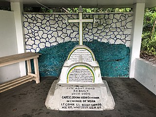
The Atantano Shrine is a historic commemorative marker near Piti, Guam. It is a pyramidal structure of coral limestone and concrete, about 2.5 metres (8.2 ft) in height, with base dimensions of 1.6 metres (5.2 ft). It is topped by a wooden cross and protected by an open concrete shelter. The monument was built in at least three stages, the early stages acting as bases for the mounting of the later ones. Panels on three sides carry inscriptions. The oldest inscription marks the initial construction of the road between Piti and Agat under the governorship of Don Felipe Cerain in 1784–85. The second inscription commemorates the creation of rice fields in the area under by Governor Don Francisco Villabos in 1832–34, and the third marks the reconstruction of the coast road during the governorship of Edward John Dorn in 1908–09. Commemorative markers of this type were a fixture of Spanish colonial administration that were adopted by Guamanians. The shrine has been the site of annual festivities since before World War II.
The Agana Historic District in Hagåtña, Guam is a 2-acre (0.81 ha) historic district that was listed on the U.S. National Register of Historic Places in 1985. It includes five contributing buildings: the Calvo-Torres, Rosario, Martinez-Notley, Lujan and Leon Guerrero houses. The area is roughly bounded by 2nd S., 3rd S., and 9th W., Santa Cruz and Legaspi Sts. in Agana.

The Nan'yō Kōhatsu Kabushiki Kaisha complex was the main support base of the Nan'yō Kōhatsu Kabushiki Kaisha (NKKK) on the island Tinian in the Northern Mariana Islands. The NKKK was an economic development company established by the Empire of Japan to develop the territories of the South Seas Mandate, which it oversaw between the First and Second World Wars. In the Northern Marianas, the company aggressively developed arable areas for sugar cane farming, importing workers from Japan, Okinawa, and Korea. Each of the three major islands had major support facility. On Tinian, this area, now roughly where the island's largest community, San Jose is located on the south coast, consisted of an extensive development, most of which was destroyed during the Battle of Tinian in the Second World War. Of this large complex, only four buildings or structures remain, all of which have been listed on the United States National Register of Historic Places, as rare surviving examples of pre-war Japanese architecture on the islands.
The Baza Outdoor Oven is a 20th-century version of a traditional hotnu, or outside oven, on the island of Guam. This oven is located at the end of Beatrice Baza Drive in the village of Yona. It was built in 1952 out of brick and concrete, but is based on traditional forms that have been in use on Guam since they were introduced by the Spanish in the 17th century. It is a barrel-shaped structure about 2 metres (6.6 ft) long, 1.5 metres (4.9 ft) wide, and 1.67 metres (5.5 ft) high. The base of the structure is poured concrete about 0.6 metres (2.0 ft) high, with the vaulted portion about 1 metre (3.3 ft) high. The interior of the vault is made out of heat-resistant bricks, while the exterior is finished in cement. The oven was used by heating it until the bricks were white, after which the burning materials were removed, the food to be cooked was added, and the main door was closed. This oven is large enough to roast four pigs.
The Cruz Water Catchment, also known historically as Finona's Water Catchment, is a historic private water supply structure in the United States territory of Guam. It is located south of Guam Highway 9 in the village of Potts Junction in the central northern part of the island. It is a circular concrete structure 3.74 metres (12.3 ft) in diameter, and is 2.55 metres (8.4 ft) in height, of which 0.87 metres (2.9 ft) is exposed above ground level. Its estimated capacity is just over 17,000 litres (4,500 US gal). It was built, according to local oral history, about 1920, and was used to capture rainfall from a nearby house that was destroyed by Typhoon Karen in 1962. The catchment was used to provide water to as many as seven local households, making possible year-round living in an area otherwise lacking fresh water.

The Gongna Beach defenses are a collection of World War II structures built on or near Gongna Beach in Tamuning on the island of Guam, now a United States territory. These defenses were erected by the Imperial Japanese Army during its occupation of the island 1941–44. The three surviving elements were listed on the National Register of Historic Places in 1991. They are located well north of the main Allied landing areas of the 1944 Battle of Guam.

The Rose Island Concrete Monument is a historic commemorative marker on Rose Island, part of Rose Atoll, a remote island located in the far eastern reaches of the territorial waters of American Samoa. The marker is a concrete structure in the shape of a truncated pyramid with a rectangular cross-section. It is 1.53 metres (5.0 ft) wide, 1.59 metres (5.2 ft) high, and 0.74 metres (2.4 ft) deep. On the west side of the marker is raised lettering stating "ROSE ISLAND / AMERICAN SAMOA / TRESPASSING PROHIBITED / WARREN J. TERHUNE / JAN 10 1920 GOVERNOR". A brass plaque on the opposite side of the monument conveys a similar message. The monument was placed in 1920 by the order of Naval Governor Warren J. Terhune during a tour he made of all of the islands of the territory of American Samoa, and serves as a continuing reminder of the American claim to the atoll.
The Ipao Pillbox I is one of three surviving World War II-era fortifications on Ypao Point, located west of Tumon Bay on the west side of the island of Guam. It is built into the limestone cliff overlooking the beach on the property of the Hilton Hotel, about 17 metres (56 ft) in from the high tide line. Its walls are fashioned out of coral rock and cement, varying in thickness from 1 metre (3.3 ft) to 1.6 metres (5.2 ft). Its entrance is on the east wall, and its gun port faces north, overlooking Ypao Channel. Parts of the structure have been restored.
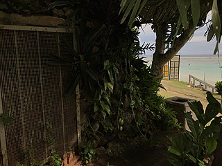
The Malessu' Pillbox is a World War II-era Japanese-built defensive fortification on the shore of Merizo, Guam. Located about 15 metres (49 ft) from the high-tide line at Merizo Beach, it is a rectangular structure built of steel-reinforced concrete and basalt rock. It is 3.9 metres (13 ft) deep, 2.4 metres (7.9 ft) wide, and about 2.42 metres (7.9 ft) high, although only about 0.75 metres (2.5 ft) of the structure is visible above ground. Its gun port has a view of the Merizo pier, and is approximately at ground level. It was built by Japanese defenders during their occupation of the island 1941–44.
The Mana Pillbox is an old World War II-era Japanese-built defensive fortification on the east coast of the island of Guam. It is located south of the village of Talofofo, about 50 metres (160 ft) inland from the point marking the south end of As Anite Cove. It is a structure built out of coral limestone and concrete, with an interior chamber about 3 by 1.8 metres in size. The entrance is on the south side, measuring 0.85 by 1.45 metres. There is one gun port, facing north, measuring 0.32 by .9 metres. The structure was designed to be well hidden in view from the sea and air. It was built, probably by conscripted Chamorro labor, during the Japanese occupation period 1941–44.
The Pago Bay Japanese pillboxes are a pair of World War II-era coastal defense pillboxes located on the shore of Pago Bay, located on the central east coast of Guam. Built out of steel-reinforced concrete mixed with coral stone, these two structures were built by Japanese defenders during their occupation of the island between 1941 and 1944. They were listed on the National Register of Historic Places in 1991 as Pagu' Pillbox I and Pagu' Pillbox II. Neither of these would have seen substantial action during the 1944 liberation of Guam, whose military activities were focused on the western, central, and northern parts of the island.
The Paulino Outdoor Oven is a 20th-century version of a traditional hotnu, or outside oven, on the island of Guam. This oven is located on Paulino family land of Bear Rock Lane on Agfayan Point, a peninsula on the south side of Agfayan Bay in the village of Inarajan. It was built in 1947 for the Paulinos by Jesus Menu Cristostomo out of modern materials, following a traditional form that has been in use on Guam since these ovens were introduced by the Spanish in the 17th century. It is a barrel-shaped structure about 1.85 metres (6.1 ft) long, 1.68 metres (5.5 ft) wide, and 0.8 metres (2.6 ft) high. The base of the structure is coral stone mixed with mortar. The interior of the vault is made out of heat-resistant bricks, while the exterior is finished in alternating layers of red tile and mortar. The oven was used by the Paulino family to prepare baked goods such as dinner rolls and wedding cakes, and to roast pigs. When recorded in 2010, it was in deteriorating condition.
The Won Pat Outdoor Oven is a 20th-century version of a traditional hotnu, or outside oven, on the island of Guam. It is located on a vacant lot off Mansanita Court in Sinajana. Although built out of modern materials, it follows a traditional form that has been in use on Guam since these ovens were introduced by the Spanish in the 17th century. It is a barrel-shaped structure about 1.6 metres (5.2 ft) long, 1.3 metres (4.3 ft) wide, rising to a height of 0.55 metres (1.8 ft). The base of the structure is built of rough limestone and mortar. The interior of the vault is made out of heat-resistant bricks, while the exterior is finished in concrete. When recorded in 2010, its main opening was damaged.
The Talofofo Pillbox is a historic World War II-era defensive fortification in Talofofo, Guam. It is located near the coast, about 127 metres (417 ft) south of the mouth of the Togcha River and 27 metres (89 ft) inland from the high-tide line. It is roughly 2.75 by 3.0 metres, built out of concrete and coral limestone. Its walls are about 0.5 metres (1.6 ft) thick, with an embrasure providing a view of the Togcha River, and a window looking over the coast to the east. Its entrance is on the landward (south) side. This structure was built under the direction of the Imperial Japanese Army during its occupation of Guam in 1941–44.
The Tokcha' Pillbox is a Japanese-built World War II-era defensive fortification on the island of Guam. It is built on a limestone terrace on Togcha Point, about 1 mile (1.6 km) north of the Togcha River and 0.7 miles (1.1 km) south of the Ylig River. It is set in a depression excavated from the limestone about 15 metres (49 ft) inland from the high tide land and 1 metre (3.3 ft) above sea level. It is a roughly rectangular structure built out of steel-reinforced concrete filled with coral and beach aggregate. The entrance is on the north wall, sheltered by a wall of coral blocks, and the gun port is on the south wall. This structure was built under the direction of the Japanese military during their occupation of the island 1941–44.
The Tumon Bay Japanese fortifications are a collection of World War II-era military structures along the coast of Guam in and near the village of Tumon. Many of these structures were listed on the National Register of Historic Places in 1991, using the alternate spelling "Tomhum". They include pillboxes on or close to the beach, and concrete structures and caves located a short way inland on the limestone cliffs that overlook the beach.

