Queen Valley, Arizona

Last updated

Queen Valley, Arizona
CDP
Pinal County Arizona Incorporated and Unincorporated areas Queen Valley highlighted.svg
Location in Pinal County and the state of Arizona
Coordinates: 33°17′42″N111°17′52″W / 33.29500°N 111.29778°W / 33.29500; -111.29778
CountryUnited States
State Arizona
County Pinal
Area
[1]
  Total9.74 sq mi (25.22 km2)
  Land9.74 sq mi (25.22 km2)
  Water0.00 sq mi (0.00 km2)
Elevation
2,037 ft (621 m)
Population
 (2020)
  Total967
  Density99.31/sq mi (38.35/km2)
Time zone UTC-7 (MST (no DST))
ZIP code
85118
Area code 520
FIPS code 04-58290
GNIS feature ID 0040413

Queen Valley is a census-designated place (CDP) in north central Pinal County, Arizona, United States. The population was 820 at the 2000 census.

Contents

Geography

Queen Valley is located at 33°17′42″N111°17′52″W / 33.29500°N 111.29778°W / 33.29500; -111.29778 . [2] at an elevation of 2000 feet along the south side of the west flowing Queen Creek. The Tonto National Forest boundary and Comet Peak (2681 ft.) lie 1.5 miles to the east. The dam for the Whitlow Ranch Flood Control Basin is one mile to the east. [3]

Florence Junction lies 5.4 kilometres (3.4 mi) to the southwest along US Route 60 and Queen Valley Road connects Queen Valley with US 60, two miles east of Florence Junction. [3] Apache Junction lies to the northwest. The Superstition Mountains lie to the north and northwest. [4]

According to the United States Census Bureau, the CDP has a total area of 9.6 square miles (24.9 km2), all land.

Demographics

Historical population
CensusPop.Note
2020 967
U.S. Decennial Census [5]

As of the census [6] of 2000, there were 820 people, 417 households, and 296 families living in the CDP. The population density was 85.3 inhabitants per square mile (32.9/km2). There were 595 housing units at an average density of 61.9 per square mile (23.9/km2). The racial makeup of the CDP was 96.6% White, 0.1% Black or African American, 0.5% Native American, 0.1% Asian, 0.1% Pacific Islander, 1.5% from other races, and 1.1% from two or more races. 6.1% of the population were Hispanic or Latino of any race.

There were 417 households, out of which 5.5% had children under the age of 18 living with them, 67.1% were married couples living together, 2.6% had a female householder with no husband present, and 29.0% were non-families. 24.7% of all households were made up of individuals, and 15.3% had someone living alone who was 65 years of age or older. The average household size was 1.97 and the average family size was 2.26.

In the CDP, the population was spread out, with 7.4% under the age of 18, 1.5% from 18 to 24, 10.4% from 25 to 44, 31.3% from 45 to 64, and 49.4% who were 65 years of age or older. The median age was 65 years. For every 100 females, there were 103.0 males. For every 100 females age 18 and over, there were 100.8 males.

The median income for a household in the CDP was $43,188, and the median income for a family was $44,213. Males had a median income of $42,344 versus $20,764 for females. The per capita income for the CDP was $28,886. None of the families and 5.9% of the population were living below the poverty line, including no under eighteens and 6.1% of those over 64.

Related Research Articles

<span class="mw-page-title-main">Pinal County, Arizona</span> County in Arizona, United States

Pinal County is in the central part of the U.S. state of Arizona. According to the 2020 census, the population of the county was 425,264, making it Arizona's third-most populous county. The county seat is Florence. The county was founded in 1875.

<span class="mw-page-title-main">Sleetmute, Alaska</span> CDP in Alaska, United States

Sleetmute is a census-designated place (CDP) in Bethel Census Area, Alaska, United States. At the 2010 census the population was 86, down from 100 in 2000.

<span class="mw-page-title-main">LeChee, Arizona</span> CDP in Coconino County, Arizona

LeChee is a census-designated place (CDP) in Coconino County, Arizona, United States. The population was 1,443 at the 2010 census.

<span class="mw-page-title-main">Pine, Arizona</span> CDP in Gila County, Arizona

Pine is an unincorporated community and census-designated place (CDP) in Gila County, Arizona, United States. The population was 1,963 at the 2010 census. Pine was established by four Mormon families in 1879.

<span class="mw-page-title-main">Strawberry, Arizona</span> CDP in Gila County, Arizona

Strawberry is an unincorporated community and census-designated place (CDP) in Gila County, Arizona, United States. The population was 961 at the 2010 census.

<span class="mw-page-title-main">Star Valley, Arizona</span> Town in Gila County, Arizona

Star Valley is a town in Gila County, Arizona, United States, incorporated in 2005. Before incorporation, it was a census-designated place (CDP). As of the 2010 census the population of the town was 2,310.

<span class="mw-page-title-main">Tonto Basin, Arizona</span> CDP in Gila County, Arizona

Tonto Basin is a census-designated place (CDP) in Gila County, Arizona, United States. The population was 1,424 at the 2010 United States Census, up from 840 in 2000.

<span class="mw-page-title-main">Top-of-the-World, Arizona</span> CDP in Gila County, Arizona

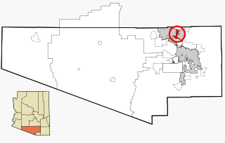
Top-of-the-World is a census-designated place (CDP) in Gila and Pinal counties in the U.S. state of Arizona. The population was 274 at the 2020 census, up from 231 at the 2010 census, and down from 330 at the 2000 census.

<span class="mw-page-title-main">Swift Trail Junction, Arizona</span> CDP in Graham County, Arizona

Swift Trail Junction is a census-designated place (CDP) in Graham County, Arizona, United States. The population was 2,935 at the 2010 census, up from 2,195 in 2000. It is part of the Safford Micropolitan Statistical Area. It is situated at the junction of U.S. Route 191 and State Route 366. The Swift Trail Parkway is a scenic highway that winds through the Coronado National Forest and provides access to the higher elevations of the Pinaleño Mountains, also known as the Graham Mountains.

<span class="mw-page-title-main">Sun Lakes, Arizona</span> CDP in Maricopa County, Arizona

Sun Lakes is an unincorporated community and census-designated place (CDP) in Maricopa County, Arizona, United States. The population was 14,868 at the 2020 census. Sun Lakes is an active adult community comprising five country club communities in three homeowner associations. These include the gated communities of Oakwood and IronWood (IronOaks), the gated and non-gated communities of Palo Verde and Cottonwood, and the non-gated community of Sun Lakes 1. Sun Lakes is a master-planned community developed by Robson Communities.

<span class="mw-page-title-main">Mohave Valley, Arizona</span> CDP in Mohave County, Arizona

Mohave Valley is an unincorporated community and census-designated place (CDP) in Mohave County, Arizona, United States. The population was 2,693 at the 2020 census. It is geographically connected to Needles, California, Fort Mohave and Bullhead City.

<span class="mw-page-title-main">Avra Valley, Arizona</span> CDP in Pima County, Arizona

Avra Valley is a census-designated place (CDP) in Pima County, Arizona, United States. The population was 6,050 at the 2010 census, up from 5,038 in 2000.

<span class="mw-page-title-main">Three Points, Arizona</span> CDP in Arizona, United States

Three Points is a census-designated place (CDP) in Pima County, Arizona, United States. The population was 5,581 at the 2010 census.

<span class="mw-page-title-main">Tortolita, Arizona</span> Former CDP in Arizona, United States

Tortolita was a census-designated place (CDP) in Pima County, Arizona, United States. The population was 3,740 at the 2000 census. Tortolita was situated between the growing incorporated towns of Oro Valley and Marana with most of the area previously part of the CDP having been annexed by the two towns during the 2000s. The remaining parts of the CDP that have not been annexed continue to be unincorporated portions of Pima County.

<span class="mw-page-title-main">Chuichu, Arizona</span> CDP in Pinal County, Arizona

Chuichu is a census-designated place (CDP) in Pinal County, Arizona, United States. The population was 308 at the 2020 census. It is the northernmost traditional village on the Tohono O'odham Nation reservation.

<span class="mw-page-title-main">Cordes Lakes, Arizona</span> CDP in Yavapai County, Arizona

Cordes Lakes is a census-designated place (CDP) in Yavapai County, Arizona, United States. The population was 2,058 at the 2000 census. The Agua Fria National Monument lies to the east and south of the community and Arcosanti is to the north.

<span class="mw-page-title-main">Old Agency, Montana</span> CDP in Montana, United States

Old Agency is a census-designated place (CDP) in Sanders County, Montana, United States. The population was 95 at the 2000 census.

<span class="mw-page-title-main">Junction City, Washington</span> Census-designated place in Washington, United States

Junction City is a census-designated place (CDP) in Grays Harbor County, Washington, United States. The population was 18 at the 2010 census.

<span class="mw-page-title-main">Gold Canyon, Arizona</span> Census-designated place in Arizona, United States

Gold Canyon is a census-designated place (CDP) and unincorporated community in Pinal County, Arizona, United States. The community is sometimes incorrectly called Gold Camp.

<span class="mw-page-title-main">Oljato-Monument Valley, Arizona</span> CDP in Navajo County, Arizona

Oljato-Monument Valley is a census-designated place (CDP) in Navajo County, Arizona, United States. The population was 154 at the 2010 census.

References

  1. "2020 U.S. Gazetteer Files". United States Census Bureau. Retrieved October 29, 2021.
  2. "US Gazetteer files: 2010, 2000, and 1990". United States Census Bureau. February 12, 2011. Retrieved April 23, 2011.
  3. 1 2 Florence Junction, Arizona, 7.5 Minute Topographic Quadrangle, USGS, 2004
  4. Mesa, Arizona, 30x60 Minute Topographic Quad, USGS, 1984
  5. "Census of Population and Housing". Census.gov. Retrieved June 4, 2016.
  6. "U.S. Census website". United States Census Bureau . Retrieved January 31, 2008.