
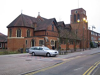
Hatfield is a town and civil parish in Hertfordshire, England, in the borough of Welwyn Hatfield. It had a population of 29,616 in 2001, 39,201 at the 2011 Census, and 41,265 at the 2021 Census. The settlement is of Saxon origin. Hatfield House, home of the Marquess of Salisbury, forms the nucleus of the old town. From the 1930s when de Havilland opened a factory, until the 1990s when British Aerospace closed it, aircraft design and manufacture employed more people there than any other industry. Hatfield was one of the post-war New Towns built around London and has much modernist architecture from the period. The University of Hertfordshire is based there.

Hertfordshire is a ceremonial county in the East of England and one of the home counties. It borders Bedfordshire to the north-west, Cambridgeshire to the north-east, Essex to the east, Greater London to the south, and Buckinghamshire to the west. The largest settlement is Watford, and the county town is Hertford.

The London Borough of Barnet is a local authority area on the northern outskirts of London. The borough was formed in 1965 from parts of the ceremonial counties of Middlesex and Hertfordshire. It is the second largest London borough by population with 389,344 inhabitants as of 2021, also making it the 17th largest district in England. The borough covers an area of 86.74 square kilometres (33 sq mi), the fourth highest of the 32 London boroughs, and has a population density of 45.8 people per hectare, which ranks it 25th.

The A41 is a trunk road between London and Birkenhead, England. Now in parts replaced by motorways, it passes through or near Watford, Kings Langley, Hemel Hempstead, Aylesbury, Bicester, Solihull, Birmingham, West Bromwich, Wolverhampton, Newport, Whitchurch, Chester and Ellesmere Port.
Borehamwood is a town in southern Hertfordshire, England, 12 miles (19 km) from Charing Cross. Borehamwood has a population of 36,322, and is within the London commuter belt. The town's film and TV studios are commonly known as Elstree Studios.

Watford is a town and borough in Hertfordshire, England, 15 mi (24 km) north-west of Central London, on the banks of the River Colne.
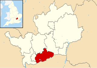
Hertsmere is a local government district with borough status in Hertfordshire, England. Its council is based in Borehamwood. Other settlements in the borough include Bushey, Elstree, Radlett and Potters Bar. The borough contains several film studios, including Elstree Studios and the BBC Elstree Centre at Borehamwood. The borough borders Three Rivers, Watford, St Albans, and Welwyn Hatfield in Hertfordshire and the three north London boroughs of Harrow, Barnet and Enfield. Hertsmere is located mainly within the M25 Motorway.
Elmbridge is a local government district with borough status in Surrey, England. Its council is based in Esher, and other notable towns and villages include Cobham, Walton-on-Thames, Weybridge and Molesey. The borough lies just outside the administrative boundary of Greater London, but is mostly within the M25 motorway which encircles London. Many of the borough's urban areas form part of the wider Greater London Built-up Area.

Cheshunt is a town in the Borough of Broxbourne in Hertfordshire, England, 13 miles (21 km) north of London on the River Lea and Lee Navigation and directly south of Broxbourne. It contains a section of the Lee Valley Park, including much of the River Lee Country Park. To the north lies Broxbourne and Wormley, Waltham Abbey to the east, Waltham Cross and Enfield to the south, and Cuffley to the west.

Epping Forest District is a local government district in Essex, England. It is named after the ancient woodland of Epping Forest, a large part of which lies within the district. The council is based in the town of Epping. The district also includes the towns of Loughton, Waltham Abbey, Chigwell, Buckhurst Hill, as well as rural areas. The district is situated in the west of the county, bordering north-eastern Greater London.

The M10 was a motorway in Hertfordshire, England, running for approximately 3 miles (4.5 km) from the M1 motorway at junction 7 near Hemel Hempstead to the A414 North Orbital Road at Park Street Roundabout, just south of St Albans. Opened in 1959, it was reclassified as part of the A414 in 2009 having only been a spur motorway for 50 years.

Radlett is a village in Hertfordshire, England, between Elstree and St Albans on Watling Street, with a population of 10,060. It is in the council district of Hertsmere in the south of the county, and forms part of the civil parish of Aldenham. Radlett is located inside the M25 motorway.

The A1081 is a road in the south of England. It starts at Luton Airport in Bedfordshire and runs to High Barnet in Greater London via Harpenden, St Albans and London Colney, a distance of around 20.5 miles (33.0 km). For most of its length, the A1081 follows the route of the original A6.

Maple Cross is a village in Hertfordshire, England, which up until the Second World War consisted of an inn, a blacksmith's shop and a few cottages. Today there are around 800 postwar council houses. Some of these have been sold into private ownership. The area is close by junction 17 of the M25 motorway, which makes up the western boundary of the village. It lies on the western fringe of Rickmansworth, about 5 miles (8.0 km) west of Watford and 6 miles north of Uxbridge.

The Henbury Loop Line, also known as the Filton to Avonmouth Line, is a railway line following the boundary between Bristol and South Gloucestershire between the Severn Beach Line at Hallen Marsh Junction, Avonmouth and the Cross Country Route/South Wales Main Line at Filton. It is currently only used for freight.

All Saints Pastoral Centre is a complex of buildings at London Colney on the southern outskirts of St Albans, Hertfordshire, England. It was built as a convent for the Anglican Society of All Saints Sisters of the Poor.
This page provides brief details of primary schools in the borough of Hertsmere in Hertfordshire, England, United Kingdom.

Napsbury Park is a residential development in Hertfordshire, England. It is located to the north of London, at Junction 22 of the M25 motorway and Junction 6 of the M1 motorway. It is protected by a Conservation Area.
Leavesden is a residential and commercial area in the northern part of Watford, England. It lies within the M25 Motorway. On its eastern side it is bounded by the M1 Motorway. Leavesden is split into two councils which are Watford Borough Council and Three Rivers District Council. Leavesden Green is an adjoining residential community which lies partly in Three Rivers and partly in the Borough of Watford.
