Surfing is a surface water sport in which an individual, a surfer, uses a board to ride on the forward section, or face, of a moving wave of water, which usually carries the surfer towards the shore. Waves suitable for surfing are primarily found on ocean shores, but can also be found in standing waves in the open ocean, in lakes, in rivers in the form of a tidal bore, or in wave pools.

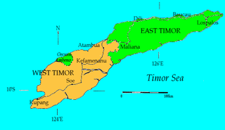
Timor is an island at the southern end of Maritime Southeast Asia, in the north of the Timor Sea. The island is divided between the sovereign states of East Timor on the eastern part and Indonesia on the western part. The Indonesian part, known as West Timor, constitutes part of the province of East Nusa Tenggara. Within West Timor lies an exclave of East Timor called Oecusse District. The island covers an area of 30,777 square kilometres. The name is a variant of timur, Malay for "east"; it is so called because it lies at the eastern end of the Lesser Sunda Islands. Mainland Australia is less than 500 km away, separated by the Timor Sea.

West Timor is an area covering the western part of the island of Timor, except for the district of Oecussi-Ambeno. Administratively, West Timor is part of East Nusa Tenggara Province, Indonesia. The capital as well as its main port is Kupang. During the colonial period, the area was named Dutch Timor and was a centre of Dutch loyalists during the Indonesian National Revolution (1945–1949). From 1949 to 1975 it was named Indonesian Timor.

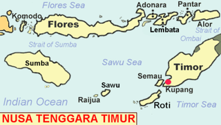
East Nusa Tenggara is the southernmost province of Indonesia. It comprises the eastern portion of the Lesser Sunda Islands, facing the Indian Ocean in the south and the Flores Sea in the north. It consists of more than 500 islands, with the largest ones being Sumba, Flores, and the western part of Timor; the latter shares a land border with the separate nation of East Timor. The province is subdivided into twenty-one regencies and the regency-level city of Kupang, which is the capital and largest city.

The Sunda Islands are a group of islands in the Malay Archipelago. They consist of the Greater Sunda Islands and the Lesser Sunda Islands

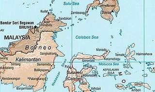
The Celebes Sea, or Sulawesi Sea, of the western Pacific Ocean is bordered on the north by the Sulu Archipelago and Sulu Sea and Mindanao Island of the Philippines, on the east by the Sangihe Islands chain, on the south by Sulawesi's Minahasa Peninsula, and on the west by northern Kalimantan in Indonesia. It extends 420 miles (675 km) north-south by 520 mi (840 km) east-west and has a total surface area of 110,000 square miles (280,000 km2), to a maximum depth of 20,300 feet (6,200 m). South of the Cape Mangkalihat, the sea opens southwest through the Makassar Strait into the Java Sea.

The Malay Archipelago also called Insulindia or the Indo-Australian Archipelago is the archipelago between Mainland Southeast Asia and Australia. It has also been called the "Malay world," "Nusantara", "East Indies" and other names over time. The name was taken from the 19th-century European concept of a Malay race, later based on the distribution of Austronesian languages.

The Mentawai Islands Regency are a regency of West Sumatra Province which consists of a chain of about a hundred islands and islets approximately 150 kilometres off the western coast of Sumatra in Indonesia. They cover a land area of 6,033.76 km2 and had a population of 76,173 at the 2010 Census and 87,623 at the 2020 Census; the official estimate as at mid 2022 was 89,401 - comprising 46,431 males and 42,970 females. Siberut at 3,838.25 square kilometres is the largest of the islands. The other major islands are Sipura, North Pagai, and South Pagai. The islands lie off the Sumatran coast, across the Mentawai Strait. The indigenous inhabitants of the islands are known as the Mentawai people. The Mentawai Islands have become a noted destination for surfing, with over 40 boats offering surf charters to international guests.

Nias is an island located off the western coast of Sumatra, Indonesia. Nias is also the name of the archipelago of which the island is the centre, but also includes the Batu Islands to the south-east and the small Hinako Islands to the west. Nias Island covers an area of 5,625.0 km2 (2,171.8 sq mi). It is mostly a lowland area rising to around 800 m (2,600 ft) above sea level. There were 756,338 inhabitants on the island at the 2010 Census; at the 2015 Intermediate Census this had risen to 798,506 and the 2020 Census resulted in a total of 880,550. The official estimate as at mid 2022 was 902,632.

The Flores Sea covers 240,000 square kilometres (93,000 sq mi) of water in Indonesia. The sea is bounded on the north by the island of Celebes and on the south by Sunda Islands of Flores and Sumbawa.

The traditional Māori greeting, the hongi is performed by two people pressing their noses together; some include, at the same time, the touching of foreheads. The greeting is used at traditional meetings among Māori people, and at major ceremonies, such as a pōwhiri. It may be followed by a handshake.

Simeulue is an island of Indonesia, 150 kilometres (93 mi) off the west coast of Sumatra. It covers an area of 1,754 square kilometres, including minor offshore islands. It had a population of 80,674 at the 2010 census and 92,865 at the 2020 census. The official estimate as at mid 2021 was 93,762. Its capital is Sinabang.

Kupang Regency is a regency in East Nusa Tenggara province of Indonesia. It occupies the far western end of Timor Island, together with the small offshore island of Semau. Other islands to the southwest and west which were formerly part of Kupang Regency have been separated administratively - the Rote Islands Group on 10 April 2002, and the Savu Islands on 29 October 2008. The capital of Kupang Regency is at Oelamasi.

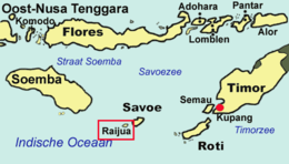
Sabu Raijua Regency is one of the regencies in the province of East Nusa Tenggara, Indonesia. It comprises the three Savu Islands, lying between Sumba and Rote Island in the Savu Sea, with a land area of 459.58 km2. The regency was established by Indonesia's Minister of Home Affairs, Mardiyanto, on 29 October 2008, when it was partitioned from Kupang Regency. The population was 72,960 at the 2010 census, and 89,327 at the 2020 Census; the official estimate as at mid 2022 was 92,792.

The Savunesepeople, also known as orangSabu or Sawu or douHawu, are the people of Savu and smaller neighbouring Raijua in East Nusa Tenggara, Indonesia.

The Hawu language is the language of the Savu people of Savu Island in Indonesia and of Raijua Island off the western tip of Savu. Hawu has been referred to by a variety of names such as Havu, Savu, Sabu, Sawu, and is known to outsiders as Savu or Sabu. Hawu belongs to the Malayo-Polynesian branch of the Austronesian language family, and is most closely related to Dhao and the languages of Sumba. Dhao was once considered a dialect of Hawu, but the two languages are not mutually intelligible.

Dana is a small uninhabited island in Indonesia. It is also known by the names Pulau Dana, Ndana, Nieuw Eiland and Hokki.
The Tanggeasinua Mountains are a range of mountains on the island of Sulawesi, in Indonesia. Running northwest–southeast, they form part of the spine of the southeast peninsula of the island. They are parallel to and east of the Mekongga Range and lie in the province of Southeast Sulawesi.
The Mekongga Mountains are a range of mountains on the island of Sulawesi (Celebes), in Indonesia. Running north-west–southeast, on the western side of the southeast peninsula of the island, they are parallel to and west of the Tanggeasinua Range and lie in the province of Southeast Sulawesi. The volcano, Mount Mekongga, is the highest point at 2,779 metres (9,117 ft).


