Ickford is a village and civil parish in the unitary authority area of Buckinghamshire, England. It is on the boundary with Oxfordshire, about 4 miles (6.4 km) west of the market town of Thame.

Wittering is a village and civil parish in the City of Peterborough unitary authority area in the ceremonial county of Cambridgeshire, England. The village is about 3 miles (5 km) south of the market town of Stamford in neighbouring Lincolnshire and about 9 miles (14 km) west of Peterborough's urban sprawl.
Wicken is a small village on the edge of The Fens near Soham in East Cambridgeshire, ten miles north east of Cambridge and five miles south of Ely. It is the site of Wicken Fen National Nature Reserve.

Landbeach is a small fen-edge English village about three miles (5 km) north of Cambridge. The parish covers an area of 9 km2 (3.5 sq mi).

Cottenham is a village in Cambridgeshire, England. Cottenham is one of the larger villages surrounding the city of Cambridge, located around five miles north of the city. The population of the civil parish at the 2011 Census was 6,095. Cottenham is one of a number of villages that make up the historical Fen Edge region in between Cambridge and Ely, which were originally settlements on the shore of the marshes close to the city of Cambridge, then an inland port.
Bury is a village and civil parish in Cambridgeshire, England. Bury lies approximately 7 miles (11 km) north/north east of Huntingdon and is near to Ramsey and St Ives. Bury is situated within Huntingdonshire which is a non-metropolitan district of Cambridgeshire as well as being a historic county of England.

Fenstanton is a village and civil parish in Cambridgeshire, England, 2 miles (3 km) south of St Ives in Huntingdonshire, a non-metropolitan district of Cambridgeshire and historic county. Fenstanton lies on the south side of the River Ouse.
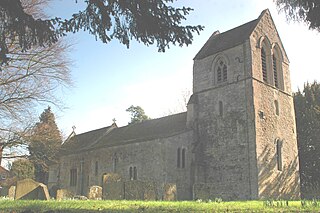
Great Raveley and Little Raveley are villages near Upwood south of Ramsey. They are located in Huntingdonshire, England, 3½ miles south-west of Ramsey. The population is shown in the civil parish of Upwood and the Raveleys.

Willingham is a village in Cambridgeshire, England. It is located in the South Cambridgeshire district and sits just outside the border of the Fens, just south of the River Great Ouse.
Dry Drayton is a village and civil parish about 5 miles (8 km) northwest of Cambridge in Cambridgeshire, England, listed as Draitone in the Domesday Book in 1086. It covers an area of 829 hectares.

Steeple Morden is a village and civil parish in Cambridgeshire, England, about 15 miles (24 km) south west of Cambridge and 5 miles (8 km) west of Royston. It is part of the South Cambridgeshire local government district.

Stetchworth is a small village and civil parish in East Cambridgeshire, England, 3 miles (5 km) to the south of the horse-racing centre of Newmarket and around 12 miles (19 km) east of Cambridge.

Witchford is a village and civil parish about 2.5 miles (4 km) west of Ely, Cambridgeshire, England. The 2011 Census recorded the parish's population as 2,385.

Walsoken is a settlement and civil parish in Norfolk, England, which is conjoined as a suburb at the northeast of the town of Wisbech, Isle of Ely, Cambridgeshire.

Shellingford, historically also spelt Shillingford, is a village and civil parish about 2+1⁄2 miles (4 km) south-east of Faringdon in the Vale of White Horse in Oxfordshire, England. It was part of Berkshire until the 1974 Local Government Act transferred it to Oxfordshire. The 2011 Census recorded the parish's population as 173.
Pondersbridge is a village in Whittlesey civil parish, part of the Fenland district of Cambridgeshire, England. Pondersbridge is essentially a settlement which has built up around the river crossing, situated on an artificial drainage cutting called Bevill's Leam. The banks of Bevill's Leam form a strong visual boundary. The older settlement has been extended on the Main Road, north-wards by the local authority housing. The settlement has very limited services and a sporadic development pattern. The main part of Pondersbridge is contained within a triangle of roads - the B1040, the B1095 and The Drove.

Leighton Bromswold is a small village and civil parish in Cambridgeshire, England. Leighton lies approximately 10 miles (16 km) west of Huntingdon. Leighton is situated within Huntingdonshire which is a non-metropolitan district of Cambridgeshire as well as being a historic county of England. The civil parish of which it is part is called Leighton and in 2001 had a population of 224, falling to 210 at the 2011 Census. The parish covers an area of 3,128 acres (1,266 ha).
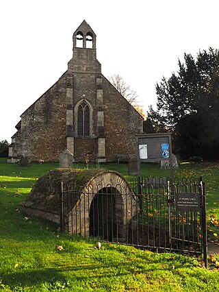
St Michael's Church is a redundant Anglican church in the village of Longstanton, Cambridgeshire, England. It is recorded in the National Heritage List for England as a designated Grade II* listed building, and is under the care of the Churches Conservation Trust. The church stands at the south end of the village. The design of St Michael's was used for that of the Church of St. James the Less in Philadelphia, Pennsylvania, as well as St. Thomas Church in New Windsor, New York, both in 1846. It has been influential in the design of other churches in the American Gothic Revival style.
Sparsholt is a village and civil parish about 3 miles (5 km) west of Wantage in the Vale of White Horse district of Oxfordshire. The parish includes the hamlet of Westcot about 1⁄2 mile (800 m) west of the village. Sparsholt was part of Berkshire until the 1974 boundary changes transferred the Vale of White Horse to Oxfordshire.

St Peter's church is the Church of England parish church for the village of Ash in Surrey. Of 12th-century origin with later additions, the church has been Grade II* listed on the Register of Historic England since 1967. It is part of Aldershot Deanery in the Diocese of Guildford.


