Red Hill, Australian Capital Territory

Last updated

Red Hill
Canberra,  Australian Capital Territory
Red Hill shops, Canberra.jpg
Red Hill shops
Australia Capital Territory location map.svg
Red pog.svg
Red Hill
Coordinates 35°19′59″S149°07′59″E / 35.333°S 149.133°E / -35.333; 149.133
Population3,146 (SAL 2021) [1]
Established1928
Gazetted 20 September 1928
Postcode(s) 2603
Elevation634 m (2,080 ft)
Area4.87 km2 (1.9 sq mi)
Location
District South Canberra
Territory electorate(s) Kurrajong
Federal division(s) Canberra
Suburbs around Red Hill:
Deakin Forrest Griffith
Garran Red Hill Narrabundah
O'Malley Symonston Symonston

Red Hill (postcode: 2603) is a suburb of Canberra, Australian Capital Territory, Australia. The suburb is named after the northernmost hill of the ridge to the west of the suburb. The ridge is a reserve and managed as part of the Canberra Nature Park. The hill is an element of the central Canberra design axis.

Contents

History

The name 'Red Hill' was gazetted as a suburb name in 1928. This was the name associated with the hill since the days of the early settlers and probably suggested by the red soil in the area. Streets are named after ships and explorers. [2] Mugga Way is named after an Aboriginal word also associated with the locality since the days of the early settlers.

The hill was once part of the Narrabundah lease held by Charles Russell. He grazed sheep but as the suburb became built up, local pet dogs worried them and killed them. He changed to cattle and finally gave up the lease in 1992.

The Red Hill Precinct or "Old Red Hill" is bounded by Mugga Way, Moresby Street, Arthur Circle, Monaro Crescent and Flinders Way. The major streets of this area were included in an outline plan for the early development of Canberra prepared by Walter Burley Griffin in 1918. Its streetscape and landscape character reflect 1920s garden city planning. It is listed by the ACT Heritage Council. [3]

Residential land in the suburb of Red Hill was offered for sale in the first Canberra land auction conducted on 12 December 1924. By 1929, 22 houses had been built and by 1955 there were 64 houses.

Other sites in Red Hill listed by the ACT Heritage Council are:

Suburb amenities

The restaurant on Red Hill was built in 1964 and has views over Canberra Carousel on Red Hill in Canberra.jpg
The restaurant on Red Hill was built in 1964 and has views over Canberra

Canberra Nature Park: Red Hill

Entrance to Red Hill reserve, part of the Canberra Nature Park CanberraNatureParkRedHill.JPG
Entrance to Red Hill reserve, part of the Canberra Nature Park

Red Hill's most important recreational area is the hill itself. From the Canberra Times Letters to the Editor in May 2000 one resident said:

"Most Sundays I walk on the slopes of Red Hill in bush that is not pristine, not especially beautiful, but that is there close to where I live, a bit of bush rather than town earth and rock, not bitumen. There is a variety of birds, a miscellany of trees, some of them exotics, a range of weedy but pretty flowers, no doubt snakes, and certainly kangaroos. Ironically, a month ago I saw more kangaroos (a mob of 14) on Red Hill in the centre of Canberra than I saw subsequently during the entirety of a 16-day tour of the Red Centre. This Red Hill bush it can't be called wilderness makes Canberra a better place to live for the many people who do walk there and enjoy its qualities. "

Schools

Grounds and buildings of Canberra Grammar School viewed from Red Hill CGSfromRedHill.jpg
Grounds and buildings of Canberra Grammar School viewed from Red Hill

Red Hill has a local public primary school and a government pre school located in the same building complex. The Red Hill School is an accredited IB World School. There is also a Catholic primary school, St Bede's Primary School, and the Canberra Grammar School, an Anglican school for boys and girls, and a French-Australian preschool.

Red Hill residents get preference for: [8]

Notable places

Calthorpes' House

Calthorpes' House at 24 Mugga Way was built in 1927 by Harry Calthorpe, stock and station agent with the firm Woodgers & Calthorpe. Designed by the architectural firm of Oakley and Parkes, the house displays many characteristics of the Spanish Mission style. The family (Harry, his wife Del and two daughters, Del and Dawn) lived together in the house throughout the Depression and Second World War, when both girls married. After Harry's death in 1950, his wife continued to live in the house, mostly alone. While friends and neighbours redecorated their houses, she elder never did. After her death in 1979, it was recognised that an opportunity existed to preserve a house that related to Canberra's early years in staggering completeness, and the Australian Commonwealth Government bought the house, its garden and the house's contents from the two daughters in 1984.

The Australian Institute of Architects in its register of significant 20th-century architecture says the building is a rare, relatively unchanged example of a 1920s Australian home. Noting that it encapsulates family life of the time, it also points to the interior design and clinical appearance of the kitchen and bathroom, which "heralded the new social era". [9]

Boxford

A suburban garden named Boxford designed by Polly Park was divided into six separate sections, each reflecting the garden history and culture of a different part of the world. One of the gardens is in the Japanese style; another features a fountain inspired by chapel of Oscar Niemeyer in garden derived from the ideas of Burle Marx a Brazilian garden designer. The garden has been listed on the ACT Heritage Register, and it was featured in Burke's Backyard. [10]

Despite its heritage listing the garden was destroyed by new owners. [11]

Major roads

The main access to the suburb from the south is from Hindmarsh Drive onto either Mugga Way or Dalrymple Street. The main roads through the suburb are La Perouse Street, Flinders Way and Monaro Crescent. The suburb's roads are named after ships and explorers.

Demographics

The first families moved to the suburb of Red Hill in 1927 and by 1933 the suburb had a population of 132 people. Its population peaked in 1971 with 4,100 residents. At the 2021 census, Red Hill had a population of 3,146, [12] little changed from its population of 3,170 in 2016, [13] 3,249 in 2011 [14] and 3,143 in 2006 [15] and 3,062 in 2001. [16] The population number has changed little over the last 30 years: in 2001 there were 16 fewer people than in 1996; 32 more people than in 1991.

The median age was 42 years; [12] an increase over the median age of 39 recorded in the 2006 census [15] and 37 years recorded in both the 1996 and 1991 censuses.

The mean household size was 2.8 persons. [12]

In the 2021 census, 79.1% of dwellings were separate houses, 7.3% were semi detached, row or terrace houses and townhouses and 13.4% were flats, units or apartments. [12]

Of all occupied private dwellings in the 2021 census, 39.2% were fully owned, 35.8% were being purchased and 21.8% were being rented. [12]

Politics

2022 Federal Election [17]
  Labor 44.03%
  Liberal 30.03%
  Greens 18.76%
  Independent 5.43%
2020 ACT Election [18]
  Liberal 36.6%
  Labor 33.9%
  Greens 16.3%
 Canberra Progressives6.6%

Red Hill is located within the federal electorate of Canberra, which is currently represented by Alicia Payne in the House of Representatives. In the ACT Legislative Assembly, Red Hill is part of the electorate of Kurrajong, which elects five members on the basis of proportional representation, currently two Labor, two Greens and one Liberal. [19] Polling place statistics are shown to the right for the Red Hill polling place at Red Hill School in the 2022 federal [17] and 2020 ACT [18] elections.

Geography

Davidson Trig Point on Red Hill DavidsonTrig.jpg
Davidson Trig Point on Red Hill

The Red Hill ridge forms the south-west boundary of the suburb. The ridge separates the central Canberra valley from Woden Valley. The northernmost peak is Red Hill, the Davidson Trig is on the middle point, and Mount Mugga is on the southernmost point of the ridge across Hindmarsh Drive.

The suburb occupies 4.87 km² and has a population density of 634/km².

Geology

The Red Hill ridge is said by geologists to be an "erosion residual" resulting from metamorphisis of sedimentary rock. The Yarralumla Formation sediments were toughened by thermal metamorphism from a small granite intrusion to the south thereby providing the resistant core of the ridge. The granite is deeply weathered and does not outcrop but is evident by the smooth slopes and deep red soils on the lower slopes to the north-west by the road to the Federal Golf Course. [20] This intrusion is known as Federal Golf Course Tonalite. It is dated at 417±8 Mya. It is completely crystalline with mineral content of plagioclase, hornblende, biotite and interstitial quartz and no potash feldspar.

The type of red soil is known as terra rossa.

Rock location summary

Mount Painter Volcanics dark grey to green grey dacitic tuff is found in all except the west. This includes most of the built up area. Yarralumla formation outcrops on Red Hill down to Mugga Way. The Federal Golf Course hanging off the west side of Red Hill also counts as part of the suburb. It has a Silurian tonalite intrusion under the whole course referred to as granite above. [21]

Related Research Articles

<span class="mw-page-title-main">Belconnen</span> Place in Australian Capital Territory

Belconnen is a district in the Australian Capital Territory in Australia. The district is subdivided into 27 divisions (suburbs), sections and blocks.

<span class="mw-page-title-main">Deakin, Australian Capital Territory</span> Suburb of Canberra, Australia

Deakin is a suburb of Canberra, Australian Capital Territory, Australia. Development began in the 1920s, although the vast majority of the suburb was built after 1945. It is a largely residential suburb. It includes The Lodge, and the Royal Australian Mint.

Forrest is a suburb of Canberra, Australian Capital Territory, Australia. Forrest is named after Sir John Forrest, an explorer, legislator, federalist, Premier of Western Australia, and one of the fathers of the Australian Constitution. Streets in Forrest are named after explorers and governors. According to the Australian Bureau of Statistics Forrest is the second most Socio-Economic advantaged location in Australia after the neighbouring suburb of Barton.

<span class="mw-page-title-main">Barton, Australian Capital Territory</span> Suburb of Canberra, Australia

Barton is a suburb of Canberra, Australian Capital Territory, Australia. At the 2021 census, Barton had a population of 1,946 people.

<span class="mw-page-title-main">Griffith, Australian Capital Territory</span> Suburb of Canberra, Australia

Griffith is an early inner-south suburb of Canberra, Australian Capital Territory, Australia.

<span class="mw-page-title-main">Narrabundah, Australian Capital Territory</span> Suburb of Canberra, Australia

Narrabundah is a leafy, medium density suburb of Canberra, Australian Capital Territory, located in the inner south of the city.

South Canberra, or the Inner South, is a subdivision of Canberra Central in the Australian Capital Territory in Australia.

<span class="mw-page-title-main">Lyneham, Australian Capital Territory</span> Suburb of Canberra, Australia

Lyneham is a suburb of Canberra, Australia in the North Canberra district. It is named after Sir William Lyne, premier of New South Wales from 1899 to 1901. The suburb name was gazetted in 1928, but development did not commence until 1958. The streets of Lyneham are named after artists and people associated with the development of early Canberra.

<span class="mw-page-title-main">Waramanga, Australian Capital Territory</span> Suburb of Canberra, Australian Capital Territory

Waramanga is a suburb of Canberra, Australian Capital Territory, Australia in the district of Weston Creek.

<span class="mw-page-title-main">Ainslie, Australian Capital Territory</span> Suburb of Canberra, Australia

Ainslie is a suburb of Canberra, Australia in the North Canberra district.

<span class="mw-page-title-main">Duffy, Australian Capital Territory</span> Suburb of Canberra, Australian Capital Territory

Duffy is a suburb of Canberra, Australian Capital Territory, Australia, located in the district of Weston Creek.

<span class="mw-page-title-main">O'Malley, Australian Capital Territory</span> Suburb of Canberra, Australian Capital Territory

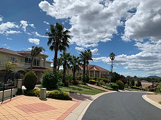
O'Malley is an affluent suburb of Canberra, Australian Capital Territory. At the 2021 census, O'Malley had a population of 928 people. There are numerous embassies in O'Malley. The suburb is named after King O'Malley, who was the politician who arranged the competition for a design for Canberra. Streets in O'Malley are named with Aboriginal words.

<span class="mw-page-title-main">O'Connor, Australian Capital Territory</span> Suburb of Canberra, Australia

O'Connor is an affluent suburb of Canberra, Australia in the North Canberra district characterised by its leafy, heritage listed streets. It was named after Richard Edward O'Connor (1851–1912), who was a judge in the High Court and a founder of the Australian constitution. Street names in O'Connor are named after explorers, Australian flora, legislators and pioneers. The suburb name was gazetted on 20 September 1928.

<span class="mw-page-title-main">Dunlop, Australian Capital Territory</span> Suburb of Canberra, Australian Capital Territory

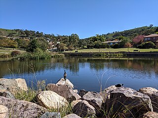
Dunlop is a suburb of the Belconnen district of Canberra, located within the Australian Capital Territory, Australia. Dunlop is at the far north-west edge of Canberra, near the border with the state of New South Wales. Approximately 11.6 kilometres (7.2 mi) north-west of the city, Dunlop is next to the suburbs of Fraser, Charnwood and Macgregor. At the edge and within Dunlop lies the Canberra Nature Park called Dunlop Grasslands Nature Reserve, West Belconnen Ponds, Jarramlee Pond and Fassifern Pond which are part of the Ginninderra Catchment.

<span class="mw-page-title-main">Chisholm, Australian Capital Territory</span> Suburb of Canberra, Australian Capital Territory

Chisholm is a suburb in the Canberra, Australia district of Tuggeranong, named after Caroline Chisholm.

<span class="mw-page-title-main">Fadden, Australian Capital Territory</span> Suburb of Canberra, Australian Capital Territory

Fadden is a suburb in the Canberra, Australia district of Tuggeranong. The postcode is 2904. The suburb is named after Sir Arthur Fadden, Prime Minister of Australia briefly in 1941. It was gazetted on 5 August 1975. Its streets are named after Queensland politicians. It is surrounded by Macarthur, Gowrie and Wanniassa. It is bounded by Erindale Drive, the Wanniassa Hills Nature Reserve, Fadden Pine Plantation and Sternberg Crescent.

Gilmore is a suburb in the Canberra, Australia district of Tuggeranong. The postcode is 2905. The suburb is named after the poet and journalist, Dame Mary Gilmore. It was gazetted on 5 August 1975. Streets are named after journalists, particularly female journalists.

<span class="mw-page-title-main">Franklin, Australian Capital Territory</span> Suburb of Canberra, Australian Capital Territory

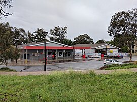
Franklin is a suburb of Canberra, Australia in the district of Gungahlin. It is named after the novelist Miles Franklin. The streets in Franklin are named after writers. It comprises an area of approximately 256 hectares. It is bounded by Flemington Road to the north and east, Well Station Drive to the south, and Gungahlin Drive to the west. Franklin is mainly a residential area with higher density, mixed-use development along Flemington Road including a local shopping centre and other retail and commercial tenancies.

<span class="mw-page-title-main">Shire of Lake Grace</span> Local government area in the Wheatbelt region of Western Australia

The Shire of Lake Grace is a local government area in the eastern Wheatbelt region of Western Australia, about 350 kilometres (217 mi) ESE of the state capital, Perth. The Shire has a land area of 10,379 square kilometres (4,007 sq mi) and its seat of government is the town of Lake Grace.

<span class="mw-page-title-main">Calthorpes' House</span> Residence in ACT, Australia

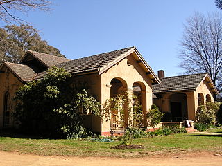
Calthorpes' House is a heritage-listed house located at 24 Mugga Way, Red Hill, Canberra, Australian Capital Territory.

References

  1. Australian Bureau of Statistics (28 June 2022). "Red Hill (ACT) (Suburb and Locality)". Australian Census 2021 QuickStats. Retrieved 28 June 2022.  OOjs UI icon edit-ltr-progressive.svg
  2. "Suburb Name search results". ACT Environment and Sustainable Development. Retrieved 9 February 2014.
  3. "20052. Red Hill Precinct (Entry to the ACT Heritage Register)" (PDF). ACT Heritage Council. Retrieved 19 March 2014.
  4. "20011. Calthorpes' House (Entry to the ACT Heritage Register)" (PDF). ACT Heritage Council. Retrieved 19 March 2014.
  5. "Heritage (Decision about Registration of the Royal Australian Institute of Architects Headquarters, Red Hill) Notice 2008 (No 1)" (PDF). ACT Heritage Council. 17 October 2008. Retrieved 19 March 2014.
  6. "Heritage (Decision about Registration of Canberra Grammar School Complex, Red Hill) Notice 2008 (No 1)" (PDF). ACT Heritage Council. 14 October 2008. Retrieved 19 March 2014.
  7. "Heritage (Decision about the Registration of 145 Mugga Way, Red Hill) Notice 2008 (No 1)" (PDF). ACT Heritage Council. 11 September 2008. Retrieved 19 March 2014.
  8. "Priority Enrolment Areas 2015 by Suburb" (Archive). Education Directorate, Australian Capital Territory. Retrieved 8 February 2016.
  9. http://www.architecture.com.au/docs/default-source/act-notable-buildings/r052_calthorpe_house_rstca.pdf [ dead link ]
  10. "Boxford Garden". Burke's Backyard. 19 September 2013. Retrieved 10 November 2016.
  11. "Sales history 21 Scarborough Street Red Hill". Allhomes. Retrieved 19 June 2020. The house was sold by the Parks in 2006. The next sale in 2017 shows a substantial rebuild of the house and that the gardens did not survive.
  12. 1 2 3 4 5 Australian Bureau of Statistics (28 June 2022). "Red Hill". 2021 Census QuickStats. Retrieved 4 September 2022. OOjs UI icon edit-ltr-progressive.svg
  13. Australian Bureau of Statistics (27 June 2017). "Red Hill (State Suburb)". 2016 Census QuickStats. Retrieved 28 June 2017. OOjs UI icon edit-ltr-progressive.svg
  14. Australian Bureau of Statistics (9 March 2006). "Red Hill (State Suburb)". 2001 Census QuickStats. Retrieved 9 February 2014. OOjs UI icon edit-ltr-progressive.svg
  15. 1 2 Australian Bureau of Statistics (25 October 2007). "Red Hill (State Suburb)". 2006 Census QuickStats. Retrieved 9 February 2014.
  16. Australian Bureau of Statistics (9 March 2006). "Red Hill". 2001 Census QuickStats. Retrieved 4 September 2022. OOjs UI icon edit-ltr-progressive.svg
  17. 1 2 "Federal Election 2022 - Red Hill Polling Place". Australian Electoral Commission. 15 June 2022. Retrieved 4 September 2022.
  18. 1 2 "2020 Results for Kurrajong Candidates at Red Hill Polling Place". ACT Electoral Commission. 11 November 2020. Retrieved 4 September 2022.
  19. "Members of the Assembly". ACT Legislative Assembly . Retrieved 3 September 2022.
  20. Sites of Significance in the ACT, volume two, Inner Canberra. National Capital Development Commission, Canberra, Australia. 1988. ISBN   0-642-13229-1., page 213.
  21. Henderson G A M and Matveev G, Geology of Canberra, Queanbeyan and Environs 1:50000 1980.