
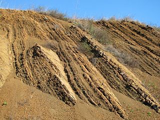
Shale is a fine-grained, clastic sedimentary rock formed from mud that is a mix of flakes of clay minerals and tiny fragments of other minerals, especially quartz and calcite. Shale is characterized by its tendency to split into thin layers (laminae) less than one centimeter in thickness. This property is called fissility. Shale is the most common sedimentary rock.

The geology of the Grand Canyon area includes one of the most complete and studied sequences of rock on Earth. The nearly 40 major sedimentary rock layers exposed in the Grand Canyon and in the Grand Canyon National Park area range in age from about 200 million to nearly 2 billion years old. Most were deposited in warm, shallow seas and near ancient, long-gone sea shores in western North America. Both marine and terrestrial sediments are represented, including lithified sand dunes from an extinct desert. There are at least 14 known unconformities in the geologic record found in the Grand Canyon.

The geology of the Grand Teton area consists of some of the oldest rocks and one of the youngest mountain ranges in North America. The Teton Range, partly located in Grand Teton National Park, started to grow some 9 million years ago. An older feature, Jackson Hole, is a basin that sits aside the range.

Underground soft-rock mining is a group of underground mining techniques used to extract coal, oil shale, potash, and other minerals or geological materials from sedimentary ("soft") rocks. Because deposits in sedimentary rocks are commonly layered and relatively less hard, the mining methods used differ from those used to mine deposits in igneous or metamorphic rocks. Underground mining techniques also differ greatly from those of surface mining.

Ruffner Mountain Nature Preserve is a 1,038 acres (4.20 km2) nature preserve located in the eastern portion of Jefferson County, Alabama, in the City of Birmingham's historic South East Lake neighborhood. The preserve includes a visitor center containing native Alabama animals including raptors, snakes, turtles, and owls. The Ruffner Mountain area was home to iron ore mines and stone quarries, supplying the area's steel mills.

The Laramie Formation is a geologic formation of Late Cretaceous (Maastrichtian) age, named by Clarence King in 1876 for exposures in northeastern Colorado, in the United States. It was deposited on a coastal plain and in coastal swamps that flanked the Western Interior Seaway. It contains coal, clay and uranium deposits, as well as plant and animal fossils, including dinosaur remains.

The Red Mountain Expressway Cut, also known as the Red Mountain Geological Cut, is a section of Red Mountain that was blasted and removed in the 1960s to allow the Red Mountain Expressway to enter downtown Birmingham, Alabama. This highway links Birmingham with its southern suburbs of Homewood, Mountain Brook, and Vestavia Hills. It has spurred suburban growth towards the south of Birmingham. This section also provides the route for U.S. Route 31 (US 31) to the south and US 280 to the southeast.
The Woodward Iron Company was founded on December 31, 1881, by brothers William and Joseph Woodward. William was the company president and Joseph was the company secretary. The company operated iron and coal mines, quarries and furnaces; these were connected by a private industrial railroad based in Bessemer, Alabama. The company administrative office was located near Woodward Ore Mine #1, south of Paul's Hill in Bessemer.
The Pyne Mine was a vertical shaft iron ore mine operated by the Woodward Iron Company and located near the Lacey's Chapel community outside Bessemer, Alabama, in Shades Valley. It was, along with Woodward's Songo Mine, one of only two shaft mines dug in the Birmingham District, and the last ore mine to operate in the region, closing in 1971.
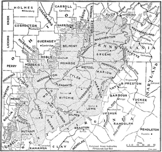
The Pittsburgh Coal Seam is the thickest and most extensive coal bed in the Appalachian Basin; hence, it is the most economically important coal bed in the eastern United States. The Upper Pennsylvanian Pittsburgh coal bed of the Monongahela Group is extensive and continuous, extending over 11,000 mi2 through 53 counties. It extends from Allegany County, Maryland to Belmont County, Ohio and from Allegheny County, Pennsylvania southwest to Putnam County, West Virginia.

The Cleveland Ironstone Formation is a sequence of marine ironstone seams interbedded with shale and siltstone units which collectively form a part of the Lower Jurassic System of rocks underlying Cleveland in North Yorkshire. Exploitation of the ironstone seams became a major driving force behind the industrialisation of the Teesside district during the mid- to late-1800s.
The Espada Formation is a sedimentary rock formation widespread in Santa Barbara County, California. Of late Jurassic to Cretaceous age, the unit consists primarily of shale with some interbedded thin layers of sandstone, conglomerate, and limestone.

The Cathedral Formation is a stratigraphic unit in the southern Canadian Rockies of Alberta and British Columbia, on the western edge of the Western Canada Sedimentary Basin. It is a thick sequence of carbonate rocks of Middle Cambrian age. It was named for Cathedral Mountain in Yoho National Park by Charles Doolittle Walcott, the discoverer of the Burgess shale fossils.

The Tonto Group is a name for an assemblage of related sedimentary strata, collectively known by geologists as a Group, that comprises the basal sequence Paleozoic strata exposed in the sides of the Grand Canyon. As currently defined, the Tonto groups consists of the Sixtymile Formation, Tapeats Sandstone, Bright Angel Shale, Muav Limestone, and Frenchman Mountain Dolostone. Historically, it included only the Tapeats Sandstone, Bright Angel Shale, and Muav Limestone. Because these units are defined by lithology and three of them interfinger and intergrade laterally, they lack the simple layer cake geology as they are typically portrayed as having and geological mapping of them is complicated.

The Benton Shale is a geologic formation name historically used in Montana, Wyoming, North Dakota, South Dakota, Colorado, Kansas, and Nebraska. In the "mile high" plains in the center of the continent, the named layers preserve marine fossils from the Late Cretaceous Period. The term Benton Limestone has also been used to refer to the chalky portions of the strata, especially the beds of the strata presently classified as Greenhorn Limestone, particularly the Fencepost limestone.

The Abo Formation is a geologic formation in New Mexico. It contains fossils characteristic of the Cisuralian epoch of the Permian period.
Sliabh an Iarainn, anglicized Slieve Anierin, is a large hill in County Leitrim, Ireland. It rises to 585 metres (1,919 ft) and lies east of Lough Allen and northeast of Drumshanbo. Its present form evolved from the southwestward movement of ice age glaciers over millions of years, the morainic drift heaping thousands of drumlins in the surrounding lowlands. Historically there were many iron ore deposits and ironworks in the area. Irish mythology associates the mountain with the Tuatha Dé Danann, particularly the smith god Goibniu. Sliabh an Iarainn is an important natural heritage site with exposed marine and coastal fauna of paleontological interest
The geology of Morocco formed beginning up to two billion years ago, in the Paleoproterozoic and potentially even earlier. It was affected by the Pan-African orogeny, although the later Hercynian orogeny produced fewer changes and left the Maseta Domain, a large area of remnant Paleozoic massifs. During the Paleozoic, extensive sedimentary deposits preserved marine fossils. Throughout the Mesozoic, the rifting apart of Pangaea to form the Atlantic Ocean created basins and fault blocks, which were blanketed in terrestrial and marine sediments—particularly as a major marine transgression flooded much of the region. In the Cenozoic, a microcontinent covered in sedimentary rocks from the Triassic and Cretaceous collided with northern Morocco, forming the Rif region. Morocco has extensive phosphate and salt reserves, as well as resources such as lead, zinc, copper and silver.
The geology of South Dakota began to form more than 2.5 billion years ago in the Archean eon of the Precambrian. Igneous crystalline basement rock continued to emplace through the Proterozoic, interspersed with sediments and volcanic materials. Large limestone and shale deposits formed during the Paleozoic, during prevalent shallow marine conditions, followed by red beds during terrestrial conditions in the Triassic. The Western Interior Seaway flooded the region, creating vast shale, chalk and coal beds in the Cretaceous as the Laramide orogeny began to form the Rocky Mountains. The Black Hills were uplifted in the early Cenozoic, followed by long-running periods of erosion, sediment deposition and volcanic ash fall, forming the Badlands and storing marine and mammal fossils. Much of the state's landscape was reworked during several phases of glaciation in the Pleistocene. South Dakota has extensive mineral resources in the Black Hills and some oil and gas extraction in the Williston Basin. The Homestake Mine, active until 2002, was a major gold mine that reached up to 8000 feet underground and is now used for dark matter and neutrino research.
The geology of Utah includes rocks formed at the edge of the proto-North American continent during the Precambrian. A shallow marine sedimentary environment covered the region for much of the Paleozoic and Mesozoic, followed by dryland conditions, volcanism and the formation of the basin and range terrain in the Cenozoic. Utah is a state in the western United States.


