
Brandenburg, officially the State of Brandenburg, is a state in northeastern Germany. Brandenburg borders the states of Mecklenburg-Vorpommern, Lower Saxony, Saxony-Anhalt, and Saxony, as well as the country of Poland. With an area of 29,480 square kilometres and a population of 2.5 million residents, it is the fifth-largest German state by area and the tenth-most populous. Potsdam is the state capital and largest city, and other major towns are Cottbus, Brandenburg an der Havel and Frankfurt (Oder).

Cottbus or Chóśebuz is a university city and the second-largest city in the German state of Brandenburg after the state capital of Potsdam. With around 98,000 inhabitants, it is the most populous city in Lusatia. Cottbus lies in the Sorbian settlement area of Lower Lusatia, and is the second-largest city on the River Spree after Berlin, from which it is situated around 125 km (78 mi) upstream. The city is located on the shores of Cottbus Eastern Lake, which will be Germany's largest artificial lake by surface area when flooding is completed.

Lusatia is a historical region in Central Europe, split between Germany and Poland. Lusatia stretches from the Bóbr and Kwisa rivers in the east to the Pulsnitz and Black Elster rivers in the west, and is located within the German states of Saxony and Brandenburg as well as in the Polish voivodeships of Lower Silesia and Lubusz. Lusatia's central rivers are the Spree and the Lusatian Neisse, which constitutes the border between Germany and Poland. The Lusatian Mountains, separate Lusatia from Bohemia in the south. Lusatia is traditionally divided into Upper Lusatia and Lower Lusatia.

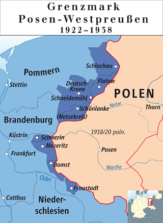
The Frontier March of Posen–West Prussia was a province of Prussia from 1922 to 1938. Posen–West Prussia was established in 1922 as a province of the Free State of Prussia within Weimar Germany, formed from merging three remaining non-contiguous territories of Posen and West Prussia, which had lost the majority of their territory to the Second Polish Republic and Free City of Danzig in the Treaty of Versailles. From 1934, Posen–West Prussia was de facto ruled by Brandenburg until it was dissolved by Nazi Germany, effective 1 October 1938 and its territory divided between the Prussian provinces of Pomerania, Brandenburg and Silesia. Schneidemühl was the provincial capital. Today, the province is entirely contained within the modern state of Poland.

Kreis Birnbaum was a district in Prussia (Kreis) in the west of the Grand Duchy of Posen and the succeeding Province of Posen, as part of Regierungsbezirk Posen between 1815 and 1920. Today the area belongs to the Polish voivodeships of Greater Poland and Lubusz.
Kreis Meseritz was a district in Prussia, first in the southern administrative Region of Posen within the Grand Duchy of Posen, then the Province of Posen, then within the Province of Posen-West Prussia and at last as part of the administrative Region of Frankfurt within the Province of Brandenburg. Its former territory presently lies in the eastern part of the Lubusz Voivodeship, a region of Poland, roughly resembling the extent of the present Międzyrzecz County.
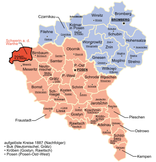
Kreis Schwerin an der Warthe was a district in Prussia, first in the southern administrative Region of Posen within the Prussian Province of Posen, then within the Province of the Frontier March of Posen-West Prussia and at last as part of the administrative Region of Frankfurt within the Province of Brandenburg. It presently lies in the western part of Polish region of Lubusz Voivodeship.

The Neumark, also known as the New March or as East Brandenburg, was a region of the Margraviate of Brandenburg and its successors located east of the Oder River in territory which became part of Poland in 1945.
Guben is a town on the Lusatian Neisse river in Lower Lusatia, in the state of Brandenburg, in eastern Germany. Located in the Spree-Neiße district, Guben has a population of 20,049. It is a divided city on the border between Germany and Poland, having been separated into Guben and Gubin in 1945.
Hoyerswerda or Wojerecy is a major district town in the district of Bautzen in the German state of Saxony. It is located in the Sorbian settlement area of Upper Lusatia, in which the Upper Sorbian language is spoken in addition to German.

Lower Lusatia is a historical region in Central Europe, stretching from the southeast of the German state of Brandenburg to the southwest of Lubusz Voivodeship in Poland. Like adjacent Upper Lusatia in the south, Lower Lusatia is a settlement area of the West Slavic Sorbs whose endangered Lower Sorbian language is related to Upper Sorbian and Polish.

Fürstenwalde/Spree is the most populous town in the Oder-Spree District of Brandenburg, in eastern Germany.

Jänschwalde is a municipality in the district of Spree-Neiße in Brandenburg, Germany. It is situated in the region of Lower Lusatia. The nearest town is Peitz; Cottbus is 25 km away.

The Province of Brandenburg was a province of Prussia from 1815 to 1945. Brandenburg was established in 1815 from the Kingdom of Prussia's core territory, comprised the bulk of the historic Margraviate of Brandenburg and the Lower Lusatia region, and became part of the German Empire in 1871. From 1918, Brandenburg was a province of the Free State of Prussia until Prussia was dissolved in 1945 after World War II, and replaced with reduced territory as the State of Brandenburg in East Germany, which was later dissolved in 1952. Following the reunification of Germany in 1990, Brandenburg was re-established as a federal state of Germany, becoming one of the new states.

Friedland is a town in the Oder-Spree district, in Brandenburg, Germany. It is situated in the historic Lower Lusatia region, about 8 km (5.0 mi) south of Beeskow, and 39 km (24 mi) north of Cottbus.

Storkow (Mark) is a town in Oder-Spree district, in Brandenburg, Germany.
Schwerin is the capital city of the German state of Mecklenburg-Vorpommern.

Bezirk Cottbus was a district of the German Democratic Republic. The administrative seat and main town was Cottbus.

The State of Brandenburg was a subdivision of the Soviet occupation zone and state of East Germany which corresponds widely to the present-day German state Brandenburg. The state was originally formed as administrative division Province of March Brandenburg by the Soviet Military Administration in Germany (SMAD) in July 1945, a re-establishment of the Prussian Province of Brandenburg, excluding the Eastern parts behind the Oder–Neisse line to Poland. With the abolition of Prussia in February 1947, it was named State of March Brandenburg but in June 1947 the SMAD forced to change the name to State of Brandenburg. In August 1945, a transfer of territory was ruled out between Allied-occupied Berlin. Compared to the administrative divisions of Nazi Germany, it comprised the Western part of the Gau March Brandenburg and small parts of Berlin.

The district of Friedeberg Nm., also called Friedeberger Kreis in the 19th century, was an administrative district from 1816 to 1945, located within the Province of Brandenburg of Prussia and Germany until 1938 and then to the Province of Pomerania. The district comprised the three towns of Driesen (Drezdenko), Friedeberg and Woldenberg (Dobiegniew). The district area is now in the Strzelce-Drezdenko County of the Polish Lubusz Voivodeship.


