
The Ames Research Center (ARC), also known as NASA Ames, is a major NASA research center at Moffett Federal Airfield in California's Silicon Valley. It was founded in 1939 as the second National Advisory Committee for Aeronautics (NACA) laboratory. That agency was dissolved and its assets and personnel transferred to the newly created National Aeronautics and Space Administration (NASA) on October 1, 1958. NASA Ames is named in honor of Joseph Sweetman Ames, a physicist and one of the founding members of NACA. At last estimate NASA Ames had over US$3 billion in capital equipment, 2,300 research personnel and a US$860 million annual budget.

A digital elevation model (DEM) or digital surface model (DSM) is a 3D computer graphics representation of elevation data to represent terrain or overlaying objects, commonly of a planet, moon, or asteroid. A "global DEM" refers to a discrete global grid. DEMs are used often in geographic information systems (GIS), and are the most common basis for digitally produced relief maps. A digital terrain model (DTM) represents specifically the ground surface while DEM and DSM may represent tree top canopy or building roofs.

The Lunar Orbiter program was a series of five uncrewed lunar orbiter missions launched by the United States in 1966 and 1967. Intended to help select Apollo landing sites by mapping the Moon's surface, they provided the first photographs from lunar orbit and photographed both the Moon and Earth.

The Goddard Space Flight Center (GSFC) is a major NASA space research laboratory located approximately 6.5 miles (10.5 km) northeast of Washington, D.C., in Greenbelt, Maryland, United States. Established on May 1, 1959, as NASA's first space flight center, GSFC employs about 10,000 civil servants and contractors. Named for American rocket propulsion pioneer Robert H. Goddard, it is one of ten major NASA field centers. GSFC is partially within the former Goddard census-designated place; it has a Greenbelt mailing address.

The Landsat program is the longest-running enterprise for acquisition of satellite imagery of Earth. It is a joint NASA / USGS program. On 23 July 1972, the Earth Resources Technology Satellite was launched. This was eventually renamed to Landsat 1 in 1975. The most recent, Landsat 9, was launched on 27 September 2021.
Landsat 7 is the seventh satellite of the Landsat program. Launched on 15 April 1999, Landsat 7's primary goal is to refresh the global archive of satellite photos, providing up-to-date and cloud-free images. The Landsat program is managed and operated by the United States Geological Survey, and data from Landsat 7 is collected and distributed by the USGS. The NASA WorldWind project allows 3D images from Landsat 7 and other sources to be freely navigated and viewed from any angle. The satellite's companion, Earth Observing-1, trailed by one minute and followed the same orbital characteristics, but in 2011 its fuel was depleted and EO-1's orbit began to degrade. Landsat 7 was built by Lockheed Martin Space Systems.

Atlas is a prominent lunar impact crater that is located in the northeast part of the Moon, to the southeast of Mare Frigoris. Just to the west is the slightly smaller but still prominent crater Hercules. Northeast of Atlas is the large crater Endymion.

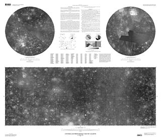
Apianus is a lunar impact crater that is located on the rugged south-central highlands of the Moon. It is named after 16th century German mathematician and astronomer Petrus Apianus. It is located to the northeast of the crater Aliacensis, and to the northwest of Poisson. The worn crater Krusenstern is attached to the west-northwestern rim.

Planetary geology, alternatively known as astrogeology or exogeology, is a planetary science discipline concerned with the geology of celestial bodies such as planets and their moons, asteroids, comets, and meteorites. Although the geo- prefix typically indicates topics of or relating to Earth, planetary geology is named as such for historical and convenience reasons; due to the types of investigations involved, it is closely linked with Earth-based geology. These investigations are centered around the composition, structure, processes, and history of a celestial body.
Ben J. Bussey is an American planetary scientist.
The Lunar and Planetary Institute (LPI) is a scientific research institute dedicated to study of the solar system, its formation, evolution, and current state. The Institute is part of the Universities Space Research Association (USRA) and is supported by the Science Mission Directorate of the National Aeronautics and Space Administration (NASA). Located at 3600 Bay Area Boulevard in Houston, Texas, the Institute serves as a scientific forum attracting visiting scientists, postdoctoral fellows, students, and resident experts; supports and serves the research community through newsletters, meetings, and other activities; collects and disseminates planetary data while facilitating the community's access to NASA astromaterials samples and facilities; engages and excites the public about space science; and invests in the development of future generations of scientists. The LPI sponsors and organizes several workshops and conferences throughout the year, including the Lunar and Planetary Science Conference (LPSC) held in March in the Houston area.

Ewen Adair Whitaker was a British-born astronomer who specialized in lunar studies. During World War II he was engaged in quality control for the lead sheathing of hollow cables strung under the English Channel as part of the "Pipe Line Under The Ocean" Project (PLUTO) to supply gasoline to Allied military vehicles in France. After the war, he obtained a position at the Royal Greenwich Observatory working on the UV spectra of stars, but became interested in lunar studies. As a sideline, Whitaker drew and published the first accurate chart of the South Polar area of the Moon in 1954, and served as director of the Lunar Section of the British Astronomical Association.
The NASA Space Science Data Coordinated Archive (NSSDCA) serves as the permanent archive for NASA space science mission data. "Space science" includes astronomy and astrophysics, solar and space plasma physics, and planetary and lunar science. As the permanent archive, NSSDCA teams with NASA's discipline-specific space science "active archives" which provide access to data to researchers and, in some cases, to the general public. NSSDCA also serves as NASA's permanent archive for space physics mission data. It provides access to several geophysical models and to data from some non-NASA mission data. NSSDCA was called the National Space Science Data Center (NSSDC) prior to March 2015.

The Astrogeology Science Center is the entity within the United States Geological Survey concerned with the study of planetary geology and planetary cartography. It is housed in the Shoemaker Building in Flagstaff, Arizona. The Center was established in 1963 by Eugene Merle Shoemaker to provide lunar geologic mapping and to assist in training astronauts destined for the Moon as part of the Apollo program.
The Planetary Data System (PDS) is a distributed data system that NASA uses to archive data collected by Solar System missions.
Integrated Software for Imagers and Spectrometers (Isis) is a specialized software package developed by the USGS to process images and spectra collected by current and past NASA planetary missions sent to Earth's Moon, Mars, Jupiter, Saturn, and other solar system bodies.

The Lunar Reconnaissance Orbiter (LRO) is a NASA robotic spacecraft currently orbiting the Moon in an eccentric polar mapping orbit. Data collected by LRO have been described as essential for planning NASA's future human and robotic missions to the Moon. Its detailed mapping program is identifying safe landing sites, locating potential resources on the Moon, characterizing the radiation environment, and demonstrating new technologies.

The United States Geological Survey (USGS), founded as the Geological Survey, is an agency of the U.S. Department of the Interior whose work spans the disciplines of biology, geography, geology, and hydrology. The agency was founded on March 3, 1879, to study the landscape of the United States, its natural resources, and the natural hazards that threaten it. The agency also makes maps of extraterrestrial planets and moons based on data from U.S. space probes.

Peter H. Schultz is Professor of Geological Sciences at Brown University specializing in the study of planetary geology, impact cratering on the Earth and other objects in the Solar System, and volcanic modifications of planetary surfaces. He was co-investigator to the NASA Science Mission Directorate spacecraft Deep Impact and the Lunar Crater Observation and Sensing Satellite (LCROSS). He was awarded the Barringer Medal of the Meteoritical Society in 2004 for his theoretical and experimental studies of impact craters.

Ronald Greeley was a Regents’ Professor in the School of Earth and Space Exploration (SESE) at Arizona State University (ASU), the Director of the NASA-ASU Regional Planetary Image Facility (RPIF), and Principal Investigator of the Planetary Aeolian Laboratory at NASA-Ames Research Center. He was involved with lunar and planetary studies since 1967 and most recently focused his research on understanding planetary surface processes and geologic histories.
