Riceville, Iowa

Last updated
Riceville, Iowa
Howard County Iowa Incorporated and Unincorporated areas Riceville Highlighted.svg
Location of Riceville, Iowa
Coordinates: 43°21′45″N92°33′12″W / 43.36250°N 92.55333°W / 43.36250; -92.55333 Coordinates: 43°21′45″N92°33′12″W / 43.36250°N 92.55333°W / 43.36250; -92.55333
Country United States
State Iowa
Counties Mitchell, Howard
Area
[1]
  Total1.07 sq mi (2.76 km2)
  Land1.06 sq mi (2.74 km2)
  Water0.01 sq mi (0.02 km2)
Elevation
1,230 ft (375 m)
Population
 (2020)
  Total806
  Density761.10/sq mi (293.86/km2)
Time zone UTC-6 (Central (CST))
  Summer (DST) UTC-5 (CDT)
ZIP code
50466
Area code 641
FIPS code 19-66585
GNIS feature ID0460608

Riceville is a city in Howard and Mitchell counties in the U.S. state of Iowa. The population was 806 at the time of the 2020 census. [2]

Contents

History

Riceville was platted in 1855 by three of the Rice brothers, Leonard, Dennis, and Gilbert. [3] Riceville was incorporated as a town in 1892. [4]

Geography

Riceville is located at 43°21′45″N92°33′12″W / 43.36250°N 92.55333°W / 43.36250; -92.55333 (43.362493, -92.553461). [5]

According to the United States Census Bureau, the city has a total area of 1.11 square miles (2.87 km2), of which 1.10 square miles (2.85 km2) is land and 0.01 square miles (0.03 km2) is water. [6]

Demographics

Historical populations
YearPop.±%
1900 804    
1910 844+5.0%
1920 960+13.7%
1930 807−15.9%
1940 910+12.8%
1950 942+3.5%
1960 898−4.7%
1970 877−2.3%
1980 919+4.8%
1990 827−10.0%
2000 740−10.5%
2010 785+6.1%
2020 806+2.7%
Source: "U.S. Census website". United States Census Bureau . Retrieved 2020-03-29. and Iowa Data Center
Source:
U.S. Decennial Census [7] [2]

2010 census

As of the census [8] of 2010, there were 785 people, 298 households, and 166 families living in the city. The population density was 713.6 inhabitants per square mile (275.5/km2). There were 379 housing units at an average density of 353.6 per square mile (136.5/km2). The racial makeup of the city was 97.7% White, 0.1% Native American, 0.8% from other races, and 1.4% from two or more races. Hispanic or Latino of any race were 2.2% of the population.

There were 341 households, of which 25.2% had children under the age of 18 living with them, 48.4% were married couples living together, 8.8% had a female householder with no husband present, 4.1% had a male householder with no wife present, and 38.7% were non-families. 36.7% of all households were made up of individuals, and 18.5% had someone living alone who was 65 years of age or older. The average household size was 2.22 and the average family size was 2.84.

The median age in the city was 45.7 years. 21.9% of residents were under the age of 18; 7.3% were between the ages of 18 and 24; 19.3% were from 25 to 44; 25.8% were from 45 to 64; and 25.6% were 65 years of age or older. The gender makeup of the city was 47.9% male and 52.1% female.

2000 census

As of the census [9] of 2000, there were 840 people, 369 households, and 225 families living in the city. The population density was 765.8 inhabitants per square mile (295.7/km2). There were 401 housing units at an average density of 365.6 per square mile (141.2/km2). The racial makeup of the city was 99.88% White, and 0.12% from two or more races.

There were 325 households, out of which 23.3% had children under the age of 18 living with them, 50.7% were married couples living together, 6.8% had a female householder with no husband present, and 39.0% were non-families. 35.5% of all households were made up of individuals, and 21.1% had someone living alone who was 65 years of age or older. The average household size was 2.18 and the average family size was 2.80.

In the city, the population was spread out, with 21.8% under the age of 18, 7.1% from 18 to 24, 21.1% from 25 to 44, 21.5% from 45 to 64, and 28.5% who were 65 years of age or older. The median age was 45 years. For every 100 females, there were 90.0 males. For every 100 females age 18 and over, there were 80.5 males.

The median income for a household in the city was $30,982, and the median income for a family was $41,786. Males had a median income of $29,091 versus $19,904 for females. The per capita income for the city was $20,661. About 4.7% of families and 4.1% of the population were below the poverty line, including 1.8% of those under age 18 and 8.0% of those age 65 or over.

Population change

Up until mid-2013, the 2010 census stated that the Riceville population was listed as 502. The population is now listed at 756, which is the correct number. The Mayor of Riceville stated that there was confusion of paperwork done by the city clerk.

Economy

Link Energy, a family owned and operated farm, uses a 2 M gallon methane digester to generate 600KW of electricity. The digester runs on manure, waste egg products, and meat packing and meat locker waste. It also makes biogas, dairy cattle bedding and biosolids for fertilizer. [10]

Notable people


Related Research Articles

<span class="mw-page-title-main">Howard County, Iowa</span> County in Iowa, United States

Howard County is a county located in the US state of Iowa. As of the 2020 census, the population was 9,469. The county seat is Cresco. The county was founded in 1851; it was named for General Tilghman Ashurst Howard, a Representative of Indiana.

<span class="mw-page-title-main">Menifee, Arkansas</span> Town in Arkansas, United States

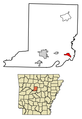
Menifee is a town in Conway County, Arkansas, United States. The population was 302 at the 2010 census.

<span class="mw-page-title-main">Udell, Iowa</span> City in Iowa, United States

Udell is a city in Appanoose County, Iowa, United States. The population was 28 at the time of the 2020 census.

<span class="mw-page-title-main">Hudson, Iowa</span> City in Iowa, United States

Hudson is a city in Black Hawk County, Iowa, United States. The population was 2,546 at the time of the 2020 census. The rural community of Hudson has grown in recent years and is included as a part of the Waterloo-Cedar Falls Metropolitan Statistical Area.

<span class="mw-page-title-main">Frederika, Iowa</span> City in Iowa, United States

Frederika is a city in Bremer County, Iowa, United States. The population was 204 at the time of the 2020 census. It is named for Fredrika Bremer, the Swedish author, for whom the surrounding county was also named.

<span class="mw-page-title-main">Yetter, Iowa</span> City in Iowa, United States

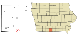
Yetter is a city in Calhoun County, Iowa, United States. The population was 19 at the time of the 2020 census.

<span class="mw-page-title-main">Protivin, Iowa</span> City in Iowa, United States

Protivin is a city in Chickasaw and Howard counties in the U.S. state of Iowa. The population was 269 at the time of the 2020 census. Early settlers named the city after the Bohemian town of Protivín in what is now the south of the Czech Republic. The current mayor of Protivin is Michael Lensing.

<span class="mw-page-title-main">Floris, Iowa</span> City in Iowa, United States

Floris is a city in Davis County, Iowa, United States. The population was 116 at the time of the 2020 census.

<span class="mw-page-title-main">Pleasanton, Iowa</span> City in Iowa, United States

Pleasanton is a city in Decatur County, Iowa, United States. The population was 32 at the time of the 2020 census.

<span class="mw-page-title-main">Masonville, Iowa</span> City in Iowa, United States

Masonville is a city in Delaware County, Iowa, United States. The population was 99 at the time of the 2020 census. The city is located on the western border between Delaware and Buchanan counties.

<span class="mw-page-title-main">West Burlington, Iowa</span> City in Iowa, United States

West Burlington is a city in Des Moines County, Iowa, United States, adjacent to the Mississippi River city of Burlington. The population was 2,968 at the 2010 census. It is part of the Burlington, IA–IL Micropolitan Statistical Area.

<span class="mw-page-title-main">St. Donatus, Iowa</span> City in Iowa, United States

St. Donatus is a city in Jackson County, Iowa, United States. The population was 120 at the time of the 2020 census. St. Donatus is known for its status as a Luxembourger village, with historic architecture and views along U.S. Route 52. It is the home of a historic Catholic church, which is dedicated to Saint Donatus of Muenstereifel, the town's namesake. It was formerly named Tete Des Morts, which is the name of a creek that flows through the village.

<span class="mw-page-title-main">Hills, Iowa</span> City in Iowa, United States

Hills is a city in Johnson County, Iowa, United States. It is part of the Iowa City, Iowa Metropolitan Statistical Area. The population was 863 at the time of the 2020 census. It is part of the Iowa City Community School District.

<span class="mw-page-title-main">College Springs, Iowa</span> City in Iowa, United States

College Springs is a city in Page County, Iowa, United States. The population was 172 at the 2020 census.

<span class="mw-page-title-main">Callender, Iowa</span> City in Iowa, United States

Callender is a city in Webster County, Iowa, United States. The population was 368 at the time of the 2020 census.

Riceville Township is a township in Becker County, Minnesota, United States. The population was 83 as of the 2010 census. Riceville Township derives its name from the Wild Rice River.

<span class="mw-page-title-main">Greenwood, Minnesota</span> City in Minnesota, United States

Greenwood is a community on Saint Albans Bay on Lake Minnetonka in Hennepin County, Minnesota, United States just northeast of the community of Excelsior, Minnesota. The population was 688 at the 2010 census.

<span class="mw-page-title-main">Holiday City, Ohio</span> Village in Ohio, United States

Holiday City is a village in Williams County, Ohio, United States. The population was 52 at the 2010 census.

<span class="mw-page-title-main">Centuria, Wisconsin</span> Village in Wisconsin, United States

Centuria is a village in Polk County, Wisconsin, United States. The population was 948 at the 2010 census.

<span class="mw-page-title-main">Barnes City, Iowa</span> City in Iowa, United States

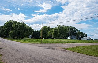
Barnes City is a city in Mahaska and Poweshiek counties in the U.S. state of Iowa. The population was 156 at the 2020 census.

References

  1. "2020 U.S. Gazetteer Files". United States Census Bureau. Retrieved March 16, 2022.
  2. 1 2 "2020 Census State Redistricting Data". census.gov. United states Census Bureau. Retrieved 12 August 2021.
  3. Clyde, Jefferson F. (1918). History of Mitchell and Worth Counties, Iowa, Volume 1. S.J. Clarke Publishing Company. p. 177.
  4. Fairbairn, Robert Herd (1919). History of Chickasaw and Howard Counties, Iowa, Volume 1. S. J. Clarke Publishing Company. p. 428.
  5. "US Gazetteer files: 2010, 2000, and 1990". United States Census Bureau. 2011-02-12. Retrieved 2011-04-23.
  6. "US Gazetteer files 2010". United States Census Bureau. Archived from the original on January 12, 2012. Retrieved 2012-05-11.
  7. "Census of Population and Housing". Census.gov. Retrieved June 4, 2015.
  8. "U.S. Census website". United States Census Bureau . Retrieved 2012-05-11.
  9. "U.S. Census website". United States Census Bureau . Retrieved 2008-01-31.
  10. "Link Energy Biodigester". Iowa Waste Reduction Center. 2016-01-05. Retrieved 2019-12-24.