Rift Valley Resources Limited is a mineral exploration company with tenements in highly prospective areas of Tanzania. [1]
Rift Valley Resources Limited is a mineral exploration company with tenements in highly prospective areas of Tanzania. [1]
Rift Valley Resources, through its wholly owned subsidiary, Rift Valley Resources (Tanzania) Limited, focuses on acquiring, exploring, and developing mineral deposits. It holds interests in 9 granted licenses and 7 licenses under application covering a total of approximately 1,183 square kilometers within geological provinces of Tanzania containing known deposits of gold, nickel, copper, and platinum group elements. The company was incorporated in 2010 and is based in Perth, Australia. [2]
Rift Valley Resources Ltd (RVR) holds interests within geological provinces of known gold, and nickel, copper, and platinum group element (PGE) endowment in Tanzania. These properties have potential for the discovery of commercial minerals; principally gold and nickel, in a number of geologic settings. [3]
The Nyanzian Supergroup rocks host the majority of known gold deposits in Tanzania and contain most of the greenstone belts found in the Tanzanian Craton. Granite rocks surrounding these greenstone belts are also known to host gold mineralisation and previous exploration and mining has been centred on these rocks. The Tanzanian Craton has many similarities to other globally-significant gold-producing cratons such as the Yilgarn Craton in Western Australia, the Kaapvaal and Zimbabwe Cratons in Southern Africa, and the Superior Craton of the Canadian Shield.
RVR's gold projects are located within three geological regions which contain both greenstone and granite rocks. The first region is termed the “Lake Victoria domain”. It comprises the granite-greenstone belts immediately to the south of Lake Victoria.
The second is termed the “northern domain”. It comprises the granite-greenstone belts to the east of Lake Victoria and north of the town of Mwanza.
The third gold region is termed the “Southern domain” and is located over granite terrane south of the Kahama District.
The Kasubuya tenement is located within the central Lake Victorian goldfields region of Tanzania some 45 km EW of the Geita town site. It extends 3.7 km to the east and 7 km to the south for a total area of about 26 km².
| Look up intrusive or doming in Wiktionary, the free dictionary. |
The Kasubuya Project is hosted dominantly within granite directly south of the regionally and historically significant gold producing greenstone belt of the Geita goldfield south of Lake Victoria. The property is located at the eastern end of the Geita greenstone where it starts to trend to the south and then southeast due to doming of the greenstone sequence over the granitic intrusive. The most northeastern tip of the Kasubuya license encompasses some Upper Nyanzian Formation comprising well-exposed banded iron formation and felsic tuffs and poorly-exposed pillowed tholeiitic basalt lava and mafic tuffs typical of the Geita greenstone belt.
The Chibango tenement is located within the central Lake Victorian goldfields region of Tanzania 10 km SW of the Geita town site and 6 km south of the Ridge 8 or Nyamulilima Hill gold deposit owned by AngloGold Ashanti. Access is via a sealed road that runs WSW from the town of Geita and crosses the extreme NW corner of the property at a distance of about 25 km. Topography is very hilly with thick native forests covering much of the property.
The Chibango Project is hosted wholly within granite directly south of the regionally- and historically-significant gold-producing greenstone belt of the Geita goldfield south of Lake Victoria. Despite strong topography, actual outcropping granite is rare and largely obscured by the dense vegetation. Significant fracturing consistent with regional structures known to control the mineralisation at Geita[ clarification needed ] and other prospects of the greenstone belt can be identified from the interpretation of regional aerial magnetic images.
The Nyasiri tenement is located in northeast Tanzania within the historically productive Mara-Musoma Goldfield some 20 km SE of North Mara (Nyabirama) mine owned by Barrick Gold. The area is accessible by Tarime airstrip then a rough road going towards the Serengeti District; the tenement straddles the western border of the Serengeti National Park.
The Nyasiri Project is hosted dominantly within granite that contains two small inliers of greenstone rocks (1 to 2 km and 2 to 3 km in area) presumably of Nyanzian origin. The western quarter of the property is covered with Bukoban Proterozoic-age sediments which unconformably overlie the Archean granite/greenstone beneath. Intrusive Proterozoic-age ultrabasic rocks occur along the southern margin of the property. Their sub-surface distribution is likely to be extensive as a gravity anomaly associated with the ultrabasic lopolith intrusion covers a large portion of the Nyasiri property. The Keserya Hills Cr-Ni-PGE prospect occurs immediately south of the Nyasiri property and the ultramafic rocks which host this prospect trend into the Nyasiri tenement. These ultramafic rocks are considered prospective for massive or disseminated Ni-Cu-PGE sulphide mineralisation or strataform Ni-Cr-PGE mineralisation.
The Buhemba South tenement is located in north east Tanzania within the historically productive Mara-Musoma Goldfield some 9 km due southeast of its namesake township, Buhemba . Access is to the Sarama property along a local inter-village vehicular track. There is a track leading more directly to the town of Buhemba but it is in poor repair and difficult to follow. Local access on the property is generally poor and via village tracks and trails.
The tenement straddles the contact between granites and greenstone belt of the Mara-Musoma goldfield. Approximately two-thirds of the tenement is underlain by granitic rock types while the north western third comprises sub-cropping volcanics of mainly mafic to intermediate composition of the Nyanzian System. Twof granite occur in the southern third of the property but most of the granite is covered by extensive mbugu plains. The volcanic rocks outcrop as a NE-SW trending range of hills and about half of the 4 km of strike length is exposed within the property boundary. Structural interpretation of the magnetic and gravity geophysical data also confirms the location and strike of the Nyanzian System rocks. -
The Sarama tenement is located in north east Tanzania within the Mara-Musoma Goldfield, 10 km due south of the township of Buhemba and 20 km east of the Suguti Project. Access is via the sealed Mwanza to Musoma highway up to the small township of Butiama, then via graded roads to the township of Buhemba and on to Sarama village located close to the northern boundary of the property. Internal access is good as the land is relatively flat with drainage typically towards the south. Sarama extends approximately 4.5 km to the east and 4 km to the south for a total area of about 18 km².
The tenement straddles the southern boundary of the Mara-Musoma greenstone belt with granites but the geology is largely covered by thin soils overlying sub-cropping residual laterites. The greenstones are most likely part of the Nyanzian System and the southern portion of the tenement is covered extensively by mbugu soils which are interpreted to overlie granite.
At least 4 km of ESE striking granite-greenstone contact has been identified from reconnaissance mapping. Structural interpretation of the magnetic and gravity geophysical data indicates a series of easterly trending structures parallel the main contact into the greenstone sequences. Mapping of artisanal workings within the northwest quadrant of the tenement identified a quartz vein up to 1m wide within an easterly striking shear zone dipping to the north at 40°. The vein is hosted by sheared mafic volcanics and had been excavated over an estimated distance of 100m.
The Suguti tenement application is located in northeast Tanzania within the historically productive Mara-Musoma Goldfield 40 km south of the township of Musoma and 25 km west southwest from the township of Buhemba. Access is gained from the sealed Mwanza to Musoma highway which passes through the western edge of the property. Internal access to the project is good with a graded access road traversing the property from east to west. The southern portion of the property is mostly soil-covered cultivated-ground that drains to the southwest into the Suguti River and then into Lake Victoria. The northern half of the property comprises steep hills and ranges with moderate to strong rock outcrop and has very little human habitation or cultivation. General land use is seasonal crop farming and no landholder access issues have been identified that will prevent exploration activities. The prospecting license extends approximately 9.3 km to the east and 8.3 km to the south for a total area of about 77 km².
The Suguti property is located within the prospective greenstone belt of the Mara–Musoma goldfield. The outcropping geology comprises an area of mafic to intermediate volcanics that form a large easterly trending range of hills in the northern portion of the property. This range is dominated by a prominent and strongly magnetic BIF extending for at least 8 km across the property. Smaller BIF units occur elsewhere within the volcanic succession and these are typically 5 to 10m wide representing thin interflow sediments to the volcanics. The greenstones are most likely part of the Upper Nyanzian System. The south west corner of the project is covered by mbugu clays which have filled a topographic depression formed by the regionally significant northwest-trending Suguti shear. The primary shear extends in excess of 50 km and has displacements of several kilometres interpreted from the geology either side of the fault contact. The shear is also readily identified from the aerial magnetic data as zones of demagnetisation. A secondary cross cutting northeast trending fault terminates the eastern end of the prominent BIF horizon. This 0600 orientation is an important control on mineralisation which is known to host gold resources elsewhere in the Mara-Musoma goldfield.
Rocks of the Karagwe–Ankolean Supergroup host most of the known nickel, copper, PGE, and tin mineralisation in Tanzania. This Supergroup forms part of the north trending Kibaran Fold Belt that extends from Zambia, through the Democratic Republic of Congo, Burundi and NW Tanzania, into Uganda and to the west of Lake Victoria. Rift Valley has secured properties along the fold belt. The properties have received very little known modern exploration but have the key components needed to host accumulations of magmatic nickel sulfides such as for the Kabanga-style mineralisation. The targets are typically greenfields and highly conceptual in nature but are well-founded on the concepts and nickel mineralisation models which have evolved over the past 40 years of exploration in Tanzania. These mobile belts are increasingly recognized for their potential to host significant nickel, copper and platinum group element (Ni-Cu-PGE) deposits like the Kabanga Deposit and the Kagera prospect, which are situated near the border with Burundi.
Greenstone belts are zones of variably metamorphosed mafic to ultramafic volcanic sequences with associated sedimentary rocks that occur within Archaean and Proterozoic cratons between granite and gneiss bodies.

The Great Dyke is a linear geological feature that trends nearly north-south through the centre of Zimbabwe passing just to the west of the capital, Harare. It consists of a band of short, narrow ridges and hills spanning for approximately 550 kilometres (340 mi). The hills become taller as the range goes north, and reach up to 460 metres (1,510 ft) above the Mvurwi Range. The range is host to vast ore deposits, including gold, silver, chromium, platinum, nickel and asbestos.
The Yilgarn Craton is a large craton that constitutes the bulk of the Western Australian land mass. It is bounded by a mixture of sedimentary basins and Proterozoic fold and thrust belts. Zircon grains in the Jack Hills, Narryer Terrane have been dated at ~4.27 Ga, with one detrital zircon dated as old as 4.4 Ga.
The Gawler Craton covers approximately 440,000 square kilometres of central South Australia. Its Precambrian crystalline basement crustal block was cratonised ca. 1550–1450 Ma. Prior to 1550 Ma the craton comprised a number of active Proterozoic orogenic belts extending back in time to at least 2450 Ma.
Kambalda type komatiitic nickel ore deposits are a class of magmatic iron-nickel-copper-platinum-group element ore deposit in which the physical processes of komatiite volcanology serve to deposit, concentrate and enrich a Fe-Ni-Cu-(PGE) sulfide melt within the lava flow environment of an erupting komatiite volcano.

The Emily Ann and Maggie Hays nickel deposits are situated approximately 150 km west of the town of Norseman, Western Australia, within the Lake Johnston Greenstone Belt.
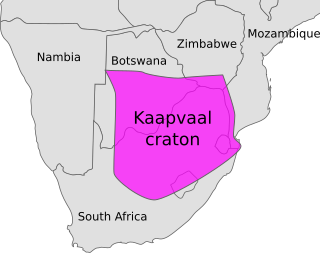
The Kaapvaal Craton, along with the Pilbara Craton of Western Australia, are the only remaining areas of pristine 3.6–2.5 Ga crust on Earth. Similarities of rock records from both these cratons, especially of the overlying late Archean sequences, suggest that they were once part of the Vaalbara supercontinent.
The Barberton Greenstone Belt, also known as the Makhonjwa Mountains, is situated on the eastern edge of Kaapvaal Craton in South Africa. It is known for its gold mineralisation and for its komatiites, an unusual type of ultramafic volcanic rock named after the Komati River that flows through the belt. Some of the oldest exposed rocks on Earth are located in the Barberton Greenstone Belt of the Swaziland–Barberton areas and these contain some of the oldest traces of life on Earth. Only the rocks found in the Isua Greenstone Belt of Western Greenland are older.
The Yellowknife greenstone belt, also called the Yellowknife Volcanic Belt, is an Archean greenstone belt in the southern Slave craton, Northwest Territories, Canada. It is mostly made of mafic volcanic rocks and is bordered to the east by batholithic intrusions of the Western Granodiorite Complex and beyond to the north by the Duckfish Lake Granite. Intrusive equivalents are collectively known as the Kam Group. Most of the Yellowknife townsite and the Con and Giant gold mines are within the Kam Group. The Yellowknife greenstone belt stands out as a positive topographic feature.

The Temagami Greenstone Belt (TGB) is a small 2.7 billion year old greenstone belt in the Temagami region of Northeastern Ontario, Canada. It represents a feature of the Superior craton, an ancient and stable part of the Earth's lithosphere that forms the core of the North American continent and Canadian Shield. The belt is composed of metamorphosed volcanic rocks that range in composition from basalt to rhyolite. These form the east-northeast trend of the belt and are overlain by metamorphosed sedimentary rocks. They were created during several volcanic episodes involving a variety of eruptive styles ranging from passive lava eruptions to viscous explosive eruptions.
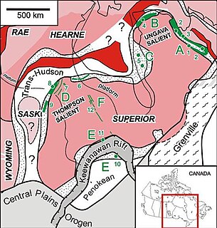
The Circum-Superior Belt is a widespread Paleoproterozoic large igneous province in the Canadian Shield of Northern, Western and Eastern Canada. It extends more than 3,400 km (2,100 mi) from northeastern Manitoba through northwestern Ontario, southern Nunavut to northern Quebec. Igneous rocks of the Circum-Superior Belt are mafic-ultramafic in composition, deposited in the Labrador Trough near Ungava Bay, the Cape Smith Belt near the southern shore of Hudson Strait and along the eastern shore of Hudson Bay in its northern portion; the Thompson and Fox River belts in the northwest and the Marquette Range Supergroup in its southern portion. The Circum Superior Belt also hosts a rare example of Proterozoic Komatiite, in the Winnipegosis komatiite belt.
The Great Lakes tectonic zone (GLTZ) is bounded by South Dakota at its tip and heads northeast to south of Duluth, Minnesota, then heads east through northern Wisconsin, Marquette, Michigan, and then trends more northeasterly to skim the northernmost shores of lakes.

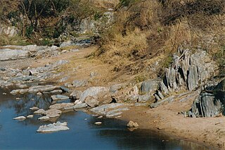
The Tanzania Craton is an old and stable part of the continental lithosphere in central Tanzania. Some of the rocks are over 3 billion years old.

The geology of Zimbabwe in southern Africa is centered on the Zimbabwe Craton, a core of Archean basement composed in the main of granitoids, schist and gneisses. It also incorporates greenstone belts comprising mafic, ultramafic and felsic volcanics which are associated with epiclastic sediments and iron formations. The craton is overlain in the north, northwest and east by Proterozoic and Phanerozoic sedimentary basins whilst to the northwest are the rocks of the Magondi Supergroup. Northwards is the Zambezi Belt and to the east the Mozambique Belt. South of the Zimbabwe Craton is the Kaapvaal Craton separated from it by the Limpopo Mobile Belt, a zone of deformation and metamorphism reflecting geological events from Archean to Mesoproterozoic times. The Zimbabwe Craton is intruded by an elongate ultramafic/mafic igneous complex known as the Great Dyke which runs for more than 500 km along a SSW/NNE oriented graben. It consists of peridotites, pyroxenites, norites and bands of chromitite.

The Barberton greenstone belt (BGB) is located in the Kapvaal craton of southeastern Africa. It characterizes one of the most well-preserved and oldest pieces of continental crust today by containing rocks in the Barberton Granite Greenstone Terrain (3.55–3.22 Ga). The BGB is a small, cusp-shaped succession of volcanic and sedimentary rocks, surrounded on all sides by granitoid plutons which range in age from >3547 to <3225 Ma. It is commonly known as the type locality of the ultramafic, extrusive volcanic rock, the komatiite. Greenstone belts are geologic regions generally composed of mafic to ultramafic volcanic sequences that have undergone metamorphism. These belts are associated with sedimentary rocks that occur within Archean and Proterozoic cratons between granitic bodies. Their name is derived from the green hue that comes from the metamorphic minerals associated with the mafic rocks. These regions are theorized to have formed at ancient oceanic spreading centers and island arcs. In simple terms, greenstone belts are described as metamorphosed volcanic belts. Being one of the few most well-preserved Archean portions of the crust, with Archean felsic volcanic rocks, the BGB is well studied. It provides present geologic evidence of Earth during the Archean (pre-3.0 Ga). Despite the BGB being a well studied area, its tectonic evolution has been the cause of much debate.
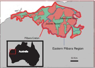
The Eastern Pilbara Craton is the eastern portion of the Pilbara Craton located in Western Australia. This region contains variably metamorphosed mafic and ultramafic greenstone belt rocks, intrusive granitic dome structures, and volcanic sedimentary rocks. These greenstone belts worldwide are thought to be the remnants of ancient volcanic belts, and are subject to much debate in today's scientific community. Areas such as Isua and Barberton which have similar lithologies and ages as Pilbara have been argued to be subduction accretion arcs, while others suggest that they are the result of vertical tectonics. This debate is crucial to investigating when/how plate tectonics began on Earth. The Pilbara Craton along with the Kaapvaal Craton are the only remaining areas of the Earth with pristine 3.6–2.5 Ga crust. The extremely old and rare nature of this crustal region makes it a valuable resource in the understanding of the evolution of the Archean Earth.

The Aravalli Mountain Range is a northeast-southwest trending orogenic belt in the northwest part of India and is part of the Indian Shield that was formed from a series of cratonic collisions. The Aravalli Mountains consist of the Aravalli and Delhi fold belts, and are collectively known as the Aravalli-Delhi orogenic belt. The whole mountain range is about 700 km long. Unlike the much younger Himalayan section nearby, the Aravalli Mountains are much older that can be traced back to the Proterozoic Eon. The collision between the Bundelkhand craton and the Marwar craton is believed to be the primary mechanism for the development of the mountain range.

The geology of the Democratic Republic of the Congo is extremely old, on the order of several billion years for many rocks. The country spans the Congo Craton: a stable section of ancient continental crust, deformed and influenced by several different mountain building orogeny events, sedimentation, volcanism and the geologically recent effects of the East Africa Rift System in the east. The country's complicated tectonic past have yielded large deposits of gold, diamonds, coltan and other valuable minerals.
The geology of Mozambique is primarily extremely old Precambrian metamorphic and igneous crystalline basement rock, formed in the Archean and Proterozoic, in some cases more than two billion years ago. Mozambique contains greenstone belts and spans the Zimbabwe Craton, a section of ancient stable crust. The region was impacted by major tectonic events, such as the mountain building Irumide orogeny, Pan-African orogeny and the Snowball Earth glaciation. Large basins that formed in the last half-billion years have filled with extensive continental and marine sedimentary rocks, including rocks of the extensive Karoo Supergroup which exist across Southern Africa. In some cases these units are capped by volcanic rocks. As a result of its complex and ancient geology, Mozambique has deposits of iron, coal, gold, mineral sands, bauxite, copper and other natural resources.

The geology of Tanzania began to form in the Precambrian, in the Archean and Proterozoic eons, in some cases more than 2.5 billion years ago. Igneous and metamorphic crystalline basement rock forms the Archean Tanzania Craton, which is surrounded by the Proterozoic Ubendian belt, Mozambique Belt and Karagwe-Ankole Belt. The region experienced downwarping of the crust during the Paleozoic and Mesozoic, as the massive Karoo Supergroup deposited. Within the past 100 million years, Tanzania has experienced marine sedimentary rock deposition along the coast and rift formation inland, which has produced large rift lakes. Tanzania has extensive, but poorly explored and exploited natural resources, including coal, gold, diamonds, graphite and clays.