
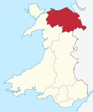
Denbighshire is a county in the north-east of Wales. It borders the Irish Sea to the north, Flintshire to the east, Wrexham to the southeast, Powys to the south, and Gwynedd and Conwy to the west. Rhyl is the largest town, and Ruthin is the administrative centre. Its borders differ from the historic county of the same name.

Until 1974, Denbighshire, or the County of Denbigh, was an administrative county in the north of Wales, later classed as one of the thirteen historic counties of Wales. It was a maritime county, that was bounded to the north by the Irish Sea, to the east by Flintshire, Cheshire and Shropshire, to the south by Montgomeryshire and Merionethshire, and to the west by Caernarfonshire.

Rhyl is a seaside town and community in Denbighshire in Wales. The town lies on the coast of North Wales, at the mouth of the River Clwyd.

The River Clwyd is a river in Wales that rises in the Clocaenog Forest 5 mi (8 km) northwest of Corwen. Its total length is 35 mi (56 km).
Clwyd is a preserved county of Wales, situated in the north-east corner of the country; it is named after the River Clwyd, which runs through the area. To the north lies the Irish Sea, with the English ceremonial counties of Cheshire to the east and Shropshire to the south-east. Powys and Gwynedd lie to the south and west respectively. Clwyd also shares a maritime boundary with Merseyside along the River Dee. Between 1974 and 1996, a slightly different area had a county council, with local government functions shared with six district councils. In 1996, Clwyd was abolished, and the new principal areas of Conwy County Borough, Denbighshire, Flintshire and Wrexham County Borough were created; under this reorganisation, "Clwyd" became a preserved county, with the name being retained for certain ceremonial functions.

St Asaph is a cathedral city and community on the River Elwy in Denbighshire, Wales. In the 2011 Census it had a population of 3,355, making it the second-smallest city in the United Kingdom in terms of population and urban area. It was historically in Flintshire.

The River Conwy is a river in north Wales. From its source to its discharge in Conwy Bay it is 55 kilometres (34 mi) long and drains an area of 678 square km. "Conwy" was formerly anglicised as "Conway."

The Diocese of Saint Asaph is a diocese of the Church in Wales in north-east Wales, named after Saint Asaph, its second bishop.

Sea trout is the common name usually applied to anadromous (sea-run) forms of brown trout, and is often referred to as Salmo trutta morpha trutta. Other names for anadromous brown trout are bull trout, sewin (Wales), peel or peal, mort, finnock (Scotland), white trout (Ireland), Dollaghan and salmon trout (culinary).
The Vale of Clwyd is a tract of low-lying ground in the county of Denbighshire in north-east Wales. The Vale extends south-southwestwards from the coast of the Irish Sea for some 20 miles forming a triangle of low ground bounded on its eastern side by the well-defined scarp of the Clwydian Range and to the west by numerous low hills. The River Clwyd which rises within Clocaenog Forest, southwest of Denbigh, runs the full length of the vale. It is joined by the two major left bank tributaries of the River Clywedog and River Elwy and the smaller right bank tributary of the River Wheeler.
Llangernyw ( ) is a rural, mostly Welsh-speaking, village and community in Conwy County Borough, North Wales.
The Denbigh Moors are an upland region in Conwy and Denbighshire in the north of Wales, between Snowdonia and the Clwydian Range. It includes the large reservoirs Llyn Brenig and Llyn Alwen, and the Clocaenog Forest, which has one of Wales's last populations of red squirrels. It also contains the open heath Hafod Elwy Moor National Nature Reserve.
The Clwydian Way is a waymarked long-distance footpath in north-east Wales, mostly running through Denbighshire.

Llanfair Talhaiarn, abbreviated to Llanfair TH, is a village and community approximately 5 miles (8.0 km) south of Abergele in Conwy county borough, Wales. Until 1974 it was included in Denbighshire. The population was 979 in 2001, increasing to 1,070 at the 2011 census with 44% being Welsh language speakers.

The Bontnewydd palaeolithic site, also known in its unmutated form as Pontnewydd, is an archaeological site near St Asaph, Denbighshire, Wales. It is one of only three sites in Britain to have produced fossils of ancient species of humans and the only one with fossils of a classic Neanderthal. It is located a few yards east of the River Elwy, near the hamlet of Bontnewydd, near Cefn Meiriadog, Denbighshire.

Pentrefoelas is a village and community in Conwy County Borough, Wales. The village lies on the A5 road between Betws-y-Coed to the west and Cerrigydrudion to the east. The Afon Merddwr river, a tributary of the River Conwy, flows through it. The community had a population of 356 at the time of the 2011 census, 70% were able to speak Welsh. It has an area of 53.86 km2 and covers a large region around the village including part of Mynydd Hiraethog, Llyn Alwen and part of Alwen Reservoir. It is in the electoral ward of Llangernyw. The community includes the small settlement of Rhydlydan.

Llannefydd is a village and community in Conwy County Borough, in Wales. It is located on the border with Denbighshire, between the Afon Aled and River Elwy, 5.7 miles (9.2 km) north west of Denbigh, 5.8 miles (9.3 km) south west of St Asaph, 6.9 miles (11.1 km) south of Abergele and 15.2 miles (24.5 km) south east of Conwy. In the 2011 census the community parish had a population of 590. The community includes the village of Cefn Berain and part of the hamlet of Bont Newydd.

The River Aled, a small river near Conwy County Borough, flows into River Elwy.

Bedd-y-Cawr Hillfort, or Bedd y Cawr Hillfort, is an Iron Age hillfort on a natural inland promontory in the community of Cefnmeiriadog in Denbighshire in North Wales. The name of the hillfort translates from the Welsh as Giant's Tomb.
St Asaph City Football Club is a Welsh football team based in St Asaph, Denbighshire, Wales. They play in the Ardal NW League.

