
Milford is a coastal city in New Haven County, Connecticut, United States, located between New Haven and Bridgeport. The population was 50,558 at the 2020 United States Census. The city includes the village of Devon and the borough of Woodmont. Milford is part of the New York-Newark Bridgeport, NY-NJ-CT-PA Combined Statistical Area.

Edgewood Historic District is a historic district located in the west-central portion of New Haven, Connecticut. It was listed on the National Register of Historic Places in 1986. A predominantly residential area roughly bisected by Edgewood Avenue, a broad boulevard which features a large central esplanade and forms the principal east-west artery through the heart of the district. The area includes 232 contributing buildings, 4 other contributing structures, and 1 contributing object. Most of these were built between about 1888 and 1900, and represent the city's first neighborhood planned under the tenets of the City Beautiful movement. They are generally either Queen Anne or Colonial Revival in style, and are set on larger lots.

The South Britain Historic District encompasses the core of the unincorporated village of South Britain in Southbury, Connecticut, United States. The village arose in the 18th century as an industrial center serving the surrounding agricultural community, powered by the Pomperaug River, and rivalled the town center of Southbury in importance. It was listed on the National Register of Historic Places in 1987.
The Simsbury Center Historic District is a 75-acre (30 ha) historic district located in the town center area of Simsbury, Connecticut. It encompasses seven blocks of Hopmeadow Street, as well as the cluster of commercial, civic, and residential buildings along Railroad, Station, and Wilcox Streets, and Phelps Lane. Although its oldest element is the cemetery, most of its buildings were built in the late 19th and early 20th century. It was listed on the National Register of Historic Places in 1996.

The Flanders Historic District is a historic district that encompasses a small cluster of late-18th to early-19th century residential structures north of the center of Kent, Connecticut, which was the original heart of the community when it was first settled. It is centered at the junction of United States Route 7 with Cobble Road and Studio Hill Road. The area was supplanted by the current town center in the 1840s. The district was listed on the National Register of Historic Places in 1979.

The Dwight Street Historic District is an irregularly shaped 135-acre (55 ha) historic district in New Haven, Connecticut. The district is located immediately west of the center of Downtown New Haven and is generally bounded by Elm Street on the north, Park Street on the east, North Frontage Road on the south, and Sherman Avenue on the west. It contains one of the city's highest concentrations of well-preserved 19th and early 20th-century residential architecture, much of which was developed for the working classes in the city's factories. It was listed on the National Register of Historic Places in 1983. The historic district includes most of the Dwight neighborhood and several blocks of the northeast corner of the West River neighborhood.
The Chelsea Parade Historic District encompasses a predominantly residential area north of downtown Norwich. Centered around the Chelsea Parade, a triangular public park, the area has long been a preferred residential area for the city's upper classes, and includes a catalog of architecture from the 18th to 20th centuries. It includes 565 contributing buildings, two other contributing sites, and six contributing objects over an area of 205 acres (83 ha). The district was listed on the National Register of Historic Places in 1989.
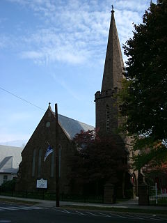
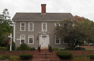
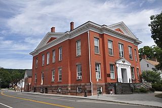
St. Peter's Episcopal Church is a historic church complex at 61, 71, and 81 River Street in Milford, Connecticut. It includes an Gothic Revival church built out of Portland, Connecticut brownstone in 1850–51, and a rectory and parish hall, added on either side of the church in the mid-1890s. The church is a significant work of Frank Wills, a major proponent of the Gothic Revival. The church is also one of the few surviving 19th-century buildings in Milford's civic center. The complex was listed on the National Register of Historic Places in 1979.

The East Jaffrey Historic District is a historic district running roughly along NH Route 124 through Jaffrey, New Hampshire. It encompasses what is now the economic and civic heart of the town, centered on the Jaffrey Mills and the crossing of the Contoocook River by Route 124. It extends as far west as St. Patrick's Church beyond Charlonne Street and as far east as the US Post Office building at Route 124 and Ellison Street. To the north it extends along Peterborough Street to Christian Court, and to the south it extends along River Street and School Street to their junction. The district includes early 19th-century residential structures, as well as industrial buildings and housing associated with the Jaffrey Mills which arose in the mid-19th century. The district was added to the National Register of Historic Places in 2002.

The Post Hill Historic District encompasses the oldest settled area of New London, Connecticut.

The Greenwich Avenue Historic District is a historic district representing the commercial and civic historical development of the downtown area of the town of Greenwich, Connecticut. The district was listed on the National Register of Historic Places on August 31, 1989. Included in the district is the Greenwich Municipal Center Historic District, which was listed on the National Register the year before for the classical revival style municipal buildings in the core of Downtown. Most of the commercial buildings in the district fall into three broad styles, reflecting the period in which they were built: Italianate, Georgian Revival, and Commercial style. The district is linear and runs north–south along the entire length of Greenwich Avenue, the main thoroughfare of Downtown Greenwich, between U.S. Route 1 and the New Haven Line railroad tracks.
The Five Mile River Landing Historic District encompasses a predominantly 19th-century residential area in the Rowayton section of Norwalk, Connecticut. It extends along Rowayton Street from Witch Lane to Pennoyer Street, and includes all of the properties on the latter as well. The area was a major local center of the shipping industry in the 19th century. The historic district was listed on the National Register of Historic Places in 2009.

The Exeter Waterfront Commercial Historic District encompasses the historic commercial and residential waterfront areas of Exeter, New Hampshire. The district extends along the north side of Water Street, roughly from Main Street to Front Street, and then along both sides of Water and High streets to the latter's junction with Portsmouth Street. It also includes properties on Chestnut Street on the north side of the Squamscott River. This area was where the early settlement of Exeter took place in 1638, and soon developed as a shipbuilding center. The district was listed on the National Register of Historic Places in 1980. It was enlarged in 1986 to include the mill complex of the Exeter Manufacturing Company on Chestnut Street.

The Springfield Downtown Historic District encompasses the historic central business district of the town of Springfield, Vermont. Located in a narrow valley on the banks of the Black River, the town's architecture is primarily reflective of its importance as a manufacturing center in the late 19th and early-to-mid 20th centuries, with a cluster of commercial buildings surrounded by residential and industrial areas. It was listed on the National Register of Historic Places in 1983, and enlarged slightly in 1986.
The New Milford Center Historic District encompasses much of the traditional civic and commercial heart of New Milford, Connecticut.
The Old Lyme Historic District encompasses the historic village center of Old Lyme, Connecticut. Located mainly on Lyme Street south of Interstate 95, the village, settled in the mid-17th century, has an architectural history dating to the early 18th century, flourishing as a shipbuilding center and home to many ship captains. It was listed on the National Register of Historic Places in 1971.

The Westbrook Town Center Historic District encompasses the historic town center of Westbrook, Connecticut. Roughly linear in shape, the district extends along the Boston Post Road, with its focal center at the junction with Essex Road. The area has been a center of civic activity since the early 18th century, even though Westbrook was not incorporated until 1840, and has residential, commercial, civic, and religious architecture covering three centuries. The district was listed on the National Register of Historic Places in 2017.

The Colony Street-West Main Street Historic District encompasses a major section of the historic downtown area of Meriden, Connecticut. Extending north and west from the junction of Colony and West Main Streets, this area was developed commercially after the arrival of the railroad line which runs just to its east. Despite some redevelopment, the historic commercial and mixed residential-commercial buildings convey the appearance of a typical late 19th or early 20th-century downtown. The district was listed on the National Register of Historic Places in 1987. Since its listing, a number of the historic buildings have been demolished.

The Pines Bridge Historic District encompasses a historic industrial and commercial village in North Haven, Connecticut. Located just west of the town green and centered around the Broadway bridge over the Quinnipiac River, the village developed first as a commercial hub around a 17th-century bridge at the site, and then as a small industrial village in the 19th century. Now mainly residential, it was listed on the National Register of Historic Places in 1988.

The Columbus Civic Center is a civic center, a collection of government buildings, museums, and open park space in Downtown Columbus, Ohio. The site is located along the Scioto Mile recreation area and historically was directly on the banks of the Scioto River.


