Fair Haven is a neighborhood in the eastern part of the city of New Haven, Connecticut, between the Mill and Quinnipiac rivers. The northeast section of the neighborhood is also known as Chatham Square.

Westville is a neighborhood of the city of New Haven, Connecticut. It is consistently ranked as one of the best neighborhoods to live in New Haven due to its high home values, low crime rates, walkable streets, proximity to downtown, and local amenities.

City Point is an area in what is now The Hill neighborhood of the city of New Haven, Connecticut, located in the southwestern portion of the city. The City Point area was, when settled and through the 18th century, a relatively narrow peninsula extending south into New Haven Harbor, located where the West River empties into the harbor. Areas adjacent to the original peninsula have since been filled in, broadening its shoulders, and Interstate 95 has cut across it. The Oyster Point Historic District is a 26-acre (11 ha) historic district encompassing an area of relatively old buildings in City Point south of I-95.

Cedar Hill is a neighborhood in New Haven, Connecticut. It includes portions of the city-designated neighborhoods of East Rock, Quinnipiac Meadows, and Mill River.
Newhallville is a neighborhood in the city of New Haven, Connecticut, named for industrialist George Newhall.

The Piquette Avenue Industrial Historic District is a historic district located along Piquette Street in Detroit, Michigan, from Woodward Avenue on the west to Hastings Street on the east. The district extends approximately one block south of Piquette to Harper, and one block north to the Grand Trunk Western Railroad Line. It was listed on the National Register of Historic Places in 2004.

The Branford Point Historic District is a historic district in Branford, Connecticut. It was listed on the National Register of Historic Places in 1988. It includes a significant portion of the Branford Point neighborhood, generally considered to be the area along the west side of the Branford Harbor to the Amtrak railroad tracks. It is bounded on the west by the Short Beach neighborhood, on the north by Branford Center, and on the east by the Branford River. Harbor Street, Maple Avenue, and Stannard Avenue are the main thoroughfares of the neighborhood. In the 2000 Census, Branford Point was included by the U.S. Census Bureau in the Branford Center census-designated place.

The Southport Historic District in the town of Fairfield, Connecticut is a 225-acre (91 ha) area historic district that was listed on the National Register of Historic Places in 1971. It preserves a portion of the modern neighborhood and former borough of Southport, Connecticut. Since the British burnt almost all of Southport's structures in 1779, there is only one home built prior to that date, the Meeker House at 824 Harbor Road, which survives.

This is a list of the National Register of Historic Places listings in Detroit, Michigan.

The Dwight Street Historic District is an irregularly shaped 135-acre (55 ha) historic district in New Haven, Connecticut. The district is located immediately west of the center of Downtown New Haven and is generally bounded by Elm Street on the north, Park Street on the east, North Frontage Road on the south, and Sherman Avenue on the west. It contains one of the city's highest concentrations of well-preserved 19th and early 20th-century residential architecture, much of which was developed for the working classes in the city's factories. It was listed on the National Register of Historic Places in 1983. The historic district includes most of the Dwight neighborhood and several blocks of the northeast corner of the West River neighborhood.
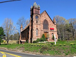
The Northford Center Historic District encompasses the historic village area of Northford in northern North Branford, Connecticut. The basically linear district extends along Middletown Avenue from the village center at its southern end, to a point beyond its northern junction with Old Post Road. The area was settled in the early 18th century, and was transformed into a rural industrial village in the 19th century by the locally prominent Maltby and Fowler families. It was listed on the National Register of Historic Places in 2002.
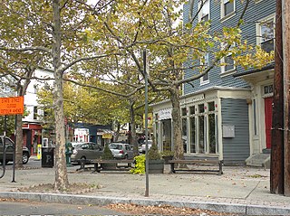
The Upper State Street Historic District encompasses a well-preserved neighborhood commercial district of the late 19th century in the East Rock neighborhood of New Haven, Connecticut. The district is an irregular strip running NNE to SSW mainly along State Street in New Haven, one block west of Interstate 91, the highway which determines the district's eastern and southern borders. The district was listed on the U.S. National Register of Historic Places in 1984.

The Water Street Historic District encompasses a historic commercial and industrial area on the west side of downtown Torrington, Connecticut. Extending roughly along Water and Church Streets between the Naugatuck River and Prospect Street, the district includes factory and commercial buildings, as well as the former Torrington Fire Department Headquarters and the civic Knights of Pythias building. Developed between about 1885 and 1920, the district was listed on the National Register of Historic Places in 2003.
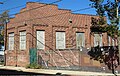
The Shore Line Electric Railway was a trolley line along the southern coastline of Connecticut, running between New Haven and Old Saybrook with additional branches to Chester and Stony Creek. Unlike most trolley lines in New England, the Shore Line Electric was a true interurban, running large railway-style cars largely on a private right-of-way rather than on public streets. Though its main line was in operation for only 15 nonconsecutive years, the Shore Line Electric briefly acquired a substantial network of trolley lines stretching across eastern Connecticut, including the Norwich and Westerly Railway, the Groton and Stonington Street Railway, and several lines of the Connecticut Company. Most of the trolley line no longer is extant, however, the Shore Line Electric Railway Power House still stands along the mouth of the Connecticut River in Old Saybrook.

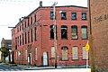
The Clark Brothers Factory No. 2, also known as Clark Brothers Bolt Company, is an industrial complex at 409 Canal Street in Southington, Connecticut. Built between 1911 and 1918, the complex is a good example of vernacular industrial architecture of the early 20th century, and was home to one of the community's major industrial employers. The complex was listed on the National Register of Historic Places in 1988.

The Bigelow-Hartford Carpet Mills were once one of the largest manufacturers of carpeting in the United States. The company's early 20th-century factories, located in Thompsonville, Connecticut, were listed on the National Register of Historic Places in 1983. Used by a succession of carpet makers until the 1960s, the company complex has for the most part been converted to residential use.

The American Mills Web Shop is a historic industrial complex at Orange Avenue and Front Street in West Haven, Connecticut. Developed between 1903 and 1914, it is a good example of industrial development of the period. The complex was listed on the National Register of Historic Places in 1983.

The Downtown Seymour Historic District encompasses most of the historic downtown of Seymour, Connecticut. Sandwiched between Connecticut Route 8 and the tracks of the former Naugatuck Railroad line, now the Waterbury Branch, it developed in the mid-19th century as a successful industrial center dominated by the production of brass goods. The district was listed on the National Register of Historic Places in 1983.

The Naugatuck Center Historic District encompasses the historic civic and business center of Naugatuck, Connecticut. Centered around the town green, the district includes churches, schools and municipal buildings, many from the late 19th or early 20th centuries, as well as a diversity of residential architecture. The district was listed on the National Register of Historic Places in 1999.

The Pines Bridge Historic District encompasses a historic industrial and commercial village in North Haven, Connecticut. Located just west of the town green and centered around the Broadway bridge over the Quinnipiac River, the village developed first as a commercial hub around a 17th-century bridge at the site, and then as a small industrial village in the 19th century. Now mainly residential, it was listed on the National Register of Historic Places in 1988.