Robinson, Illinois | |
---|---|
Coordinates: 39°0′29″N87°45′22″W / 39.00806°N 87.75611°W [1] | |
Country | United States |
State | Illinois |
County | Crawford |
Area | |
• Total | 4.76 sq mi (12.33 km2) |
• Land | 4.70 sq mi (12.17 km2) |
• Water | 0.06 sq mi (0.16 km2) |
Elevation | 525 ft (160 m) |
Population (2020) | |
• Total | 7,150 |
• Density | 1,521.60/sq mi (587.55/km2) |
Time zone | UTC-6 (CST) |
• Summer (DST) | UTC-5 (CDT) |
ZIP Code(s) | 62454 |
Area code | 618 |
FIPS code | 17-64707 |
GNIS feature ID | 2396390 [1] |
Wikimedia Commons | Robinson, Illinois |
Website | cityofrobinson |
Robinson is a city in and the county seat of Crawford County, Illinois, United States. [3] The population was 7,150 at the 2020 census, down from 7,713 at the 2010 census. [4]
Robinson is in the center of Crawford County at 39°0′22″N87°44′20″W / 39.00611°N 87.73889°W . [5] Illinois Route 33 passes through the center of the city as Main Street, leading east 7 miles (11 km) to Palestine near the Indiana border and west 24 miles (39 km) to Newton.
According to the 2021 census gazetteer files, Robinson has a total area of 4.76 square miles (12.33 km2), of which 4.70 square miles (12.17 km2) (or 98.72%) is land and 0.06 square miles (0.16 km2) (or 1.28%) is water. [6]
According to the Köppen Climate Classification system, Robinson has a humid subtropical climate, abbreviated "Cfa" on climate maps. The hottest temperature recorded in Robinson was 108 °F (42.2 °C) on July 22, 1901, while the coldest temperature recorded was −20 °F (−28.9 °C) on February 9, 1899. [7]
Climate data for Robinson, Illinois, 1991–2020 normals, extremes 1895–present | |||||||||||||
---|---|---|---|---|---|---|---|---|---|---|---|---|---|
Month | Jan | Feb | Mar | Apr | May | Jun | Jul | Aug | Sep | Oct | Nov | Dec | Year |
Record high °F (°C) | 73 (23) | 74 (23) | 87 (31) | 88 (31) | 97 (36) | 105 (41) | 108 (42) | 103 (39) | 103 (39) | 95 (35) | 83 (28) | 72 (22) | 108 (42) |
Mean maximum °F (°C) | 60.2 (15.7) | 63.6 (17.6) | 74.2 (23.4) | 83.4 (28.6) | 90.1 (32.3) | 94.9 (34.9) | 95.8 (35.4) | 95.7 (35.4) | 93.7 (34.3) | 86.6 (30.3) | 73.5 (23.1) | 62.4 (16.9) | 97.3 (36.3) |
Mean daily maximum °F (°C) | 37.1 (2.8) | 42.1 (5.6) | 52.9 (11.6) | 65.7 (18.7) | 75.7 (24.3) | 84.7 (29.3) | 87.4 (30.8) | 86.1 (30.1) | 80.9 (27.2) | 68.2 (20.1) | 53.5 (11.9) | 41.7 (5.4) | 64.7 (18.2) |
Daily mean °F (°C) | 28.6 (−1.9) | 32.8 (0.4) | 42.7 (5.9) | 54.2 (12.3) | 65.0 (18.3) | 74.1 (23.4) | 76.5 (24.7) | 74.5 (23.6) | 68.2 (20.1) | 56.0 (13.3) | 43.6 (6.4) | 33.5 (0.8) | 54.1 (12.3) |
Mean daily minimum °F (°C) | 20.1 (−6.6) | 23.4 (−4.8) | 32.5 (0.3) | 42.8 (6.0) | 54.3 (12.4) | 63.4 (17.4) | 65.7 (18.7) | 63.0 (17.2) | 55.5 (13.1) | 43.8 (6.6) | 33.7 (0.9) | 25.3 (−3.7) | 43.6 (6.5) |
Mean minimum °F (°C) | −0.5 (−18.1) | 4.5 (−15.3) | 15.2 (−9.3) | 28.6 (−1.9) | 38.7 (3.7) | 52.0 (11.1) | 55.3 (12.9) | 52.6 (11.4) | 41.0 (5.0) | 29.1 (−1.6) | 19.1 (−7.2) | 7.4 (−13.7) | −4.0 (−20.0) |
Record low °F (°C) | −17 (−27) | −20 (−29) | −5 (−21) | 22 (−6) | 26 (−3) | 39 (4) | 48 (9) | 45 (7) | 25 (−4) | 21 (−6) | 3 (−16) | −9 (−23) | −20 (−29) |
Average precipitation inches (mm) | 3.11 (79) | 2.41 (61) | 3.64 (92) | 5.17 (131) | 4.67 (119) | 4.57 (116) | 4.17 (106) | 3.45 (88) | 3.66 (93) | 3.70 (94) | 3.78 (96) | 3.15 (80) | 45.48 (1,155) |
Average precipitation days (≥ 0.01 in) | 7.5 | 7.5 | 9.8 | 9.2 | 11.2 | 8.5 | 8.6 | 6.2 | 6.1 | 7.8 | 7.6 | 8.8 | 98.8 |
Source 1: NOAA [8] | |||||||||||||
Source 2: National Weather Service [7] |
Census | Pop. | Note | %± |
---|---|---|---|
1880 | 1,380 | — | |
1890 | 1,387 | 0.5% | |
1900 | 1,683 | 21.3% | |
1910 | 3,863 | 129.5% | |
1920 | 3,375 | −12.6% | |
1930 | 3,668 | 8.7% | |
1940 | 4,311 | 17.5% | |
1950 | 6,407 | 48.6% | |
1960 | 7,226 | 12.8% | |
1970 | 7,178 | −0.7% | |
1980 | 7,285 | 1.5% | |
1990 | 6,740 | −7.5% | |
2000 | 6,822 | 1.2% | |
2010 | 7,713 | 13.1% | |
2020 | 7,150 | −7.3% | |
U.S. Decennial Census [9] |
As of the 2020 census [10] there were 7,150 people, 2,611 households, and 1,605 families residing in the city. The population density was 1,502.10 inhabitants per square mile (579.96/km2). There were 3,222 housing units at an average density of 676.89 per square mile (261.35/km2). The racial makeup of the city was 83.83% White, 7.83% African American, 0.36% Native American, 0.62% Asian, 0.01% Pacific Islander, 3.09% from other races, and 4.25% from two or more races. Hispanic or Latino of any race were 4.80% of the population.
There were 2,611 households, out of which 30.7% had children under the age of 18 living with them, 43.70% were married couples living together, 14.44% had a female householder with no husband present, and 38.53% were non-families. 33.55% of all households were made up of individuals, and 17.92% had someone living alone who was 65 years of age or older. The average household size was 2.42 and the average family size was 2.00.
The city's age distribution consisted of 14.8% under the age of 18, 8.3% from 18 to 24, 34.5% from 25 to 44, 25.3% from 45 to 64, and 17.1% who were 65 years of age or older. The median age was 40.0 years. For every 100 females, there were 162.3 males. For every 100 females age 18 and over, there were 169.9 males.
The median income for a household in the city was $45,137, and the median income for a family was $61,625. Males had a median income of $42,642 versus $25,938 for females. The per capita income for the city was $20,646. About 12.6% of families and 15.1% of the population were below the poverty line, including 13.1% of those under age 18 and 12.0% of those age 65 or over.
Major employers in the town include a refinery owned by Marathon Petroleum Company [11] and a chocolate factory for the Heath bar, first made in 1914, [12] now distributed by The Hershey Company.
The following schools are operated by Robinson Community Unit School District 2:
Calion is a second-class city in Union County, Arkansas, United States. The population was 494 at the 2010 census.
Ola is a city in Yell County, Arkansas, United States. The population was 1,281 at the 2010 census. It is roughly 15 miles south of the Russellville Metropolitan area.
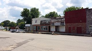
Lake Butler is a city in and the county seat of Union County, Florida, United States. The population was 1,986 at the 2020 census.
Forest View is a village in Cook County, Illinois, United States. Per the 2020 census, the population was 792. It is primarily an industrial corridor adjacent to the Chicago neighborhood of Garfield Ridge, which is on the village's southern border.
Stockton is a village in Jo Daviess County, Illinois, United States. The population was 1,862 at the 2010 census, down from 1,926 at the 2000 census.
El Paso is a city in Woodford and McLean counties in the U.S. state of Illinois. The population was 2,756 at the 2020 census. The Woodford County portion of El Paso is part of the Peoria Metropolitan Statistical Area.
Brimfield is a village in Peoria County, Illinois, United States.
Rock Rapids is a city in and the county seat of Lyon County, Iowa, United States. The population was 2,611 in the 2020 census, an increase from 2,573 in the 2000 census.
Garnett is a city in and the county seat of Anderson County, Kansas, United States. As of the 2020 census, the population of the city was 3,242.
Valley Falls is a city in Jefferson County, Kansas, United States. As of the 2020 census, the population of the city was 1,092.
Altamont is a city in Labette County, Kansas, United States. As of the 2020 census, the population of the city was 1,061.
Lansing is a city in Leavenworth County, Kansas, United States. It is situated along the west side of the Missouri River and Kansas-Missouri state border. As of the 2020 census, the population of the city was 11,239. It is the second most populous city of Leavenworth County and is a part of the Kansas City metropolitan area. The Lansing Correctional Facility, which includes the state's main maximum-security prison, is located in Lansing.
La Cygne is a city in Linn County, Kansas, United States, and situated along the Marais des Cygnes River. As of the 2020 census, the population of the city was 1,050. The city is named after the Marais des Cygnes River which is a French translation of an Osage appellation meaning "marsh of the swans".
Ness City is a city in and the county seat of Ness County, Kansas, United States. As of the 2020 census, the population of the city was 1,329. Ness City is famous for its four-story Old Ness County Bank Building located downtown, and nicknamed Skyscraper of the Plains.
Vanceburg is a home rule-class city in Lewis County, Kentucky, United States, along the Ohio River. The population was 1,428 at the 2020 census. It is the county seat of Lewis County.
Fruitland is a city in Wicomico County, Maryland, United States. The population was 4,866 at the 2010 census. It is included in the Salisbury, Maryland-Delaware Metropolitan Statistical Area.
Mosier is a city along the Columbia River in Wasco County, Oregon, United States. The population was 433 at the 2010 census.
Rangerville is a village in Cameron County, Texas, United States. It was incorporated in 1958. The population was 289 at the 2010 census, up from 203 at the 2000 census.
Ravenswood is a city in Jackson County, West Virginia, United States, along the Ohio River. The population was 3,865 at the 2020 census.
Robinson Township is one of ten townships in Crawford County, Illinois, USA. As of the 2020 census, its population was 9,303 and it contained 4,165 housing units.
After graduating from high school in Robinson, in southeastern Illinois…