Pittsburg is an unincorporated community in Columbia County, Oregon, United States. Pittsburg is located on the Nehalem River near its confluence with the East Fork Nehalem River. The Scappose-Vernonia road and the St. Helens-Pittsburg road join Oregon Route 47 near Pittsburg. Pittsburg's elevation is 584 feet (178 m).

Prospect is an unincorporated community and census-designated place (CDP) in Jackson County, in the U.S. state of Oregon. It lies along Oregon Route 62 on the Rogue River, in the Rogue River – Siskiyou National Forest. As of the 2010 census it had a population of 455.

Ruch is an unincorporated community and census-designated place (CDP) in Jackson County, Oregon, United States. It is located on Oregon Route 238, southeast of Grants Pass. As of the 2010 census it had a population of 840.
Sams Valley is an unincorporated community in Jackson County, Oregon, United States. It lies along Oregon Route 234 northeast of Gold Hill, in the Medford area.
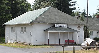
Springwater is an unincorporated rural community in Clackamas County, Oregon, United States, about three miles south of Estacada on Oregon Route 211. So-named since pioneer days, it was one of the first places on the upper Clackamas River to have a post office. Springwater post office ran from 1874–1914, with George A. Crawford as the first postmaster. The historic wooden Springwater Presbyterian Church was built c. 1890. The Springwater Grange has celebrated a Springwater Fair every year since 1923.
Woods is an unincorporated community in Tillamook County, Oregon, United States. Woods lies at the intersection of Brooten Road, Resort Drive, and Old Woods Road, along the Nestucca River just north of Pacific City and west of U.S. Route 101.
Illahe is an unincorporated community and the site of a former post office in Curry County, Oregon, United States. Located along the Rogue River about 8 miles (13 km) upriver from Agness, the area was home to Takelma Indians, then to white and Karok settlers, before becoming part of a designated wilderness. In the 21st century, it is a stopping place for hikers, boaters, and other visitors. The area has a riverside lodge and a nearby campground, both named Illahe.

Marial is an unincorporated community and the site of a former post office in Curry County, Oregon, United States. Located along the Rogue River about 48 miles (77 km) from its mouth on the Pacific Ocean, the area was home to Takelma Indians, then to white and Karok settlers, before becoming part of a designated wilderness. Buildings preserved at the Rogue River Ranch pioneer farm complex, listed on the National Register of Historic Places, represent the former center of Marial. Nearby are the Tucker Flat Campground and a riverside lodge named Marial.

Milo is an unincorporated community in Douglas County, Oregon, United States, about 17 miles (27 km) east of Canyonville on the South Umpqua River.
Wonder is an unincorporated community in Josephine County, Oregon, United States, on U.S. Route 199 about 13 miles west of Grants Pass and 8 miles east of Selma. It is within the Rogue River – Siskiyou National Forest.
Morgan is an unincorporated community in Morrow County, Oregon, United States. It lies along Oregon Route 74 between Cecil and Ione, northwest of Heppner.
Gravelford is an unincorporated community in Coos County, Oregon, United States. It is about 8 miles (13 km) northeast of Myrtle Point, at the confluence of the North Fork Coquille River and the East Fork Coquille River.
Dora is an unincorporated community in Coos County, Oregon, United States. It is about 19 miles (31 km) east of Coquille near the East Fork Coquille River on the former route of the Coos Bay Wagon Road. It is in the Southern Oregon Coast Range.
Brownsboro is an unincorporated community in Jackson County, Oregon, United States, on Oregon Route 140 about 4 miles (6 km) east of Eagle Point.
Foots Creek is an unincorporated community and census-designated place (CDP) in Jackson County, in the U.S. state of Oregon. It lies along Oregon Route 99 near the mouth of Foots Creek, where it empties into the Rogue River. Interstate 5 and Valley of the Rogue State Park are on the side of the river opposite Foots Creek.
Faubion is an unincorporated community in Clackamas County, Oregon, United States. It is located about 2 miles northwest of Rhododendron, in the Mount Hood Corridor on a loop road off U.S. Route 26 near the Zigzag River.
Bagnell Ferry is an unincorporated community in Curry County, Oregon, United States. It lies along the north bank of the Rogue River about 5 miles (8 km) upstream of Gold Beach.
Beagle is an unincorporated community in Jackson County, Oregon, United States. It lies along Beagle Road, off Oregon Route 234, northeast of Gold Hill and southwest of Shady Cove in the Rogue River Valley.
Dardanelles is an unincorporated community in Jackson County, Oregon, United States. It lies opposite the city of Gold Hill on the south side of the Rogue River. Interstate 5 and Oregon Route 99 pass by Gold Hill and Dardanelles.
Table Rock is an unincorporated community in Jackson County, Oregon, United States. It lies near the Rogue River along Table Rock Road between White City and Sams Valley. The topographic features known as Upper and Lower Table Rock are slightly west of the community. Between 1853 and 1856, the Table Rock Indian Reservation lay between Upper Table Rock and Evans Creek, a Rogue River tributary to the west.