Rockbridge State Nature Preserve is a nature reserve featuring a natural bridge located in the unincorporated community of Rockbridge in Hocking County, Ohio, United States. It is part of the Hocking Hills region, but the sandstone that forms the natural bridge is located lower in the stratigraphic sequence than that which forms most of the region's notable features.

East Liberty is an unincorporated community and census-designated place (CDP) located in Perry Township, Logan County, Ohio, United States. As of the 2020 census, it had a population of 371. It is located just off U.S. Route 33, 10 miles (16 km) east of Bellefontaine and 46 miles (74 km) northwest of Columbus. It has a post office with the ZIP code 43319.
Jacksontown is a census-designated place (CDP) in central Licking Township, Licking County, Ohio, United States. It has a post office with the ZIP code 43030. It lies at the intersection of U.S. Route 40 with State Route 13.

Tippecanoe is an unincorporated community and census-designated place (CDP) in central Washington Township, Harrison County, Ohio, United States. It is located along State Route 800 in the valley of Stillwater Creek, a north-flowing tributary of the Tuscarawas River. It had a post office until 2011 with the ZIP code 44699. The population was 83 at the 2020 census.
Stony Ridge is a census-designated place (CDP) in northwestern Troy Township, Wood County, Ohio, United States. As of the 2020 census, it had a population of 434. It has a post office with the ZIP code 43463.

Kilbourne is a census-designated place in eastern Brown Township, Delaware County, Ohio, United States. As of the 2020 census it had a population of 127. The community has a post office with the ZIP code of 43032. It lies along State Route 521.
Ridgeville Corners is an unincorporated community and census-designated place (CDP) in southern Ridgeville Township, Henry County, Ohio, United States. It has a post office with the ZIP code 43555. The population was 416 at the 2020 census.

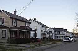
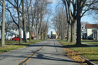
Damascus is an unincorporated community and census-designated place in southern Mahoning and northern Columbiana counties in the U.S. state of Ohio. As of the 2020 census, it had a population of 418. The community lies at the intersection of U.S. Route 62 and State Routes 173 and 534.

Haydenville is an unincorporated community and census-designated place (CDP) in southern Green Township, Hocking County, Ohio, United States. As of the 2020 census the population of the CDP was 337.

Carbon Hill is an unincorporated community and census-designated place (CDP) in central Ward Township, Hocking County, Ohio, United States. It has a post office with the ZIP code 43111. As of the 2020 census the population of the CDP was 178.

East Rochester is an unincorporated community and census-designated place (CDP) in southern West Township, Columbiana County, Ohio, United States. The population was 224 as of the 2020 census. It lies along U.S. Route 30, and has a post office with the ZIP code 44625. It is a part of the Salem micropolitan area, about 20 miles (32 km) east of Canton.

Stewart is an unincorporated community and census-designated place in central Rome Township, Athens County, Ohio, United States. The population was 221 at the 2020 census. It has a post office with the ZIP code 45778.

New Marshfield is a census-designated place in central Waterloo Township, Athens County, Ohio, United States. The population was 316 at the 2020 census. It has a post office with the ZIP code 45766. It is located along State Route 56 west of the county seat of Athens.

Millfield is a census-designated place in northern Dover Township, Athens County, Ohio, United States. It had a population of 311 at the 2020 census. It has a post office with the ZIP code 45761. It is located near State Route 13 midway between Chauncey and Jacksonville. Route 13 formerly ran through the community, but a bypass relocated it close by.

Hockingport is a census-designated place in southeastern Troy Township, Athens County, Ohio, United States. As of the 2020 census it had a population of 205. It has a post office with the ZIP code 45739. It is located at the intersection of State Routes 124 and 144.

Hannibal is a census-designated place in eastern Ohio Township, Monroe County, Ohio, United States. It has a post office with the ZIP code 43931. In the 2020 Census, it had a population of 314.

Little Hocking is a census-designated place in southern Belpre Township, Washington County, Ohio, United States. It has a post office with the ZIP code 45742. The population of the CPD was 244 at the 2020 census.

Ida is an unincorporated community and census-designated place (CDP) in Monroe County in the U.S. state of Michigan. The CDP had a population of 790 at the 2020 census. The community is mostly within Ida Township with a smaller portion extending north into Raisinville Township.
Nathalie is an unincorporated community and census-designated place (CDP) in Halifax County, Virginia, United States, in the south-central region of the state. The population as of the 2010 census was 183.
Maceo is an unincorporated community and census-designated place (CDP) in Daviess County, Kentucky, United States. As of the 2020 census, the population was 404, down from the 2010 census population of 413.