
Mount Magazine, officially named Magazine Mountain, is the highest point of the U.S. Interior Highlands and the U.S. state of Arkansas, and is the site of Mount Magazine State Park. It is a flat-topped mountain or mesa capped by hard rock and rimmed by precipitous cliffs. There are two summits atop the mountain: Signal Hill, which reaches 2,753 feet (839 m), and Mossback Ridge, which reaches 2,700 ft (823.0 m).

The Uinta Mountains are an east-west trending chain of mountains in northeastern Utah extending slightly into southern Wyoming in the United States. As a subrange of the Rocky Mountains, they are unusual for being the highest range in the contiguous United States running east to west, and lie approximately 100 miles (160 km) east of Salt Lake City. The range has peaks ranging from 11,000 to 13,528 feet, with the highest point being Kings Peak, also the highest point in Utah. The Mirror Lake Highway crosses the western half of the Uintas on its way to Wyoming.

Mount Anderson is a 7,330-foot-high (2,234 m) peak in the Olympic Mountains of the Pacific Northwest. Rising in the center of Olympic National Park in Washington state, it is the second highest peak on the Anderson Massif, after West Peak. Anderson Glacier used to be located in a cirque on the mountain's southern flank while Eel Glacier is in another cirque, northwest of the summit. Hanging Glacier is on the east side of a ridge which extends north from the peak.

The Sierra Blanca is an ultra-prominent range of volcanic mountains in Lincoln and Otero counties in the south-central part of the U.S. state of New Mexico. The range is about 40 miles (64 km) from north to south and 20 miles (32 km) wide.

Neahkahnie Mountain is a mountain, or headland, on the Oregon Coast, north of Manzanita in Oswald West State Park overlooking U.S. Route 101. The peak is part of the Northern Oregon Coast Range, which is part of the Oregon Coast Range. It is best known for stories of Spanish treasure said to be buried either at the foot of the mountain, or on its slopes.

Saddle Mountain is the tallest mountain in Clatsop County in the U.S. state of Oregon. Part of the Oregon Coast Range, Saddle Mountain is in Saddle Mountain State Natural Area in the northwest corner of Oregon. The peak is listed on Oregon's Register of Natural Heritage Resources.
South Saddle Mountain is the tallest mountain in Washington County, Oregon, United States. Part of the Oregon Coast Range, the peak is located in the Tillamook State Forest in the northwest section of the state of Oregon. It is the eighth-highest peak of the Oregon Coast Range.

The Northern Oregon Coast Range is the northern section of the Oregon Coast Range, in the Pacific Coast Ranges physiographic region, located in the northwest portion of the state of Oregon, United States. This section of the mountain range, part of the Pacific Coast Ranges, contains peaks as high as 3,710 feet (1,131 m) for Rogers Peak. Forests in these mountains are considered to be some of the most productive timber land in the world. The Central Oregon Coast Range is directly south of this section with the Southern Oregon Coast Range beyond the central range.

The Central Oregon Coast Range is the middle section of the Oregon Coast Range, in the Pacific Coast Ranges physiographic region, and located in the west-central portion of the state of Oregon, United States roughly between the Salmon River and the Umpqua River and the Willamette Valley and the Pacific Ocean. This approximately 90-mile (140 km) long mountain range contains mountains as high as 4,097 feet for Marys Peak. Portions of the range are inside the Siuslaw National Forest and three wilderness areas exist as well: Drift Creek Wilderness, Cummins Creek Wilderness and Rock Creek Wilderness.

Trask Mountain in the Northern Oregon Coast Range, is the tallest mountain in Yamhill County, Oregon. It is located in the northwest corner of the county. Evidently the mountain was named for Elbridge Trask who settled west of the peak in Tillamook County in 1852.

The Oregon Coast Range, often called simply the Coast Range and sometimes the Pacific Coast Range, is a mountain range, in the Pacific Coast Ranges physiographic region, in the U.S. state of Oregon along the Pacific Ocean. This north-south running range extends over 200 miles (320 km) from the Columbia River in the north on the border of Oregon and Washington, south to the middle fork of the Coquille River. It is 30 to 60 miles wide and averages around 1,500 feet (460 m) in elevation above sea level. The coast range has three main sections, a Northern, Central, and Southern.

The Siletz River Volcanics, located in the Oregon Coast Range, United States, are a sequence of basaltic pillow lavas that make up part of Siletzia. The basaltic pillow lavas originally came from submarine volcanoes that existed during the Eocene.

The Southern Oregon Coast Range is the southernmost section of the Oregon Coast Range, in the Pacific Coast Ranges, located in the southwest portion of the state of Oregon, United States, roughly between the Umpqua River and the middle fork of the Coquille River, beyond which are the Klamath Mountains. To the east is the Umpqua Valley and to the west the Pacific Ocean. This approximately 55-mile (89 km)-long mountain range contains mountains as high as 3,547 feet (1,081 m) for Bone Mountain. The mountains are known locally in the Roseburg area as the Callahan Mountains, or simply as The Callahans.

The Wah Wah Mountains are a north-south trending range in west-central Utah, part of the larger Basin and Range Province. It is bounded by Pine Valley to the west, Wah Wah Valley to the east, the Escalante Desert to the south, and on trend with the Confusion Range to the north. The Wah Wah Mountains are located in Beaver and Millard counties. State Route 21 bisects the range, crossing over Wah Wah Summit at about 6,500 feet (1,980 m) above sea level. Elevations range from about 6,000 feet (1,800 m) at the mountain front to 9,393 feet (2,863 m) in the southern Wah Wahs.

The Coast Range ecoregion is a Level III ecoregion designated by the Environmental Protection Agency (EPA) in the U.S. states of Washington, Oregon, and California. It stretches along the Pacific Coast from the tip of the Olympic Peninsula in the north to the San Francisco Bay in the south, including Grays Harbor, Willapa Bay, and the Long Beach Peninsula in Washington, the entire length of the Oregon Coast, and the Northern California Coast. Named for the Coast Range mountains, it encompasses the lower elevations of the Olympic Mountains, the Oregon Coast Range, the Californian North Coast Ranges, and surrounding lowlands.

The Coyote Mountains are a small mountain range in San Diego and Imperial Counties in southern California. The Coyotes form a narrow ESE trending 2 mi (3.2 km) wide range with a length of about 12 mi (19 km). The southeast end turns and forms a 2 mi (3.2 km) north trending "hook". The highest point is Carrizo Mountain on the northeast end with an elevation of 2,408 feet (734 m). Mine Peak at the northwest end of the range has an elevation of 1,850 ft (560 m). Coyote Wash along I-8 along the southeast margin of the range is 100 to 300 feet in elevation. Plaster City lies in the Yuha Desert about 5.5 mi (8.9 km) east of the east end of the range.

The Ochoco Mountains are a mountain range in central Oregon in the United States, located at the western end of the Blue Mountains. They were formed when Permian, Triassic, and Jurassic rocks were slowly uplifted by volcanic eruptions to form the Clarno Formation. Today, the highest point in the range is Lookout Mountain. The dominant vegetation on the west side of the range is old-growth ponderosa pine; on the east side, western juniper is common. The western area of the mountains is administered by the Ochoco National Forest, while the southeastern section is part of the Malheur National Forest. The Ochoco Mountains are used for hiking, camping, bird watching, rockhounding, and hunting, as well as cross-country skiing in the winter.
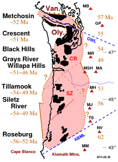
Siletzia is a massive formation of early to middle Eocene epoch marine basalts and interbedded sediments in the forearc of the Cascadia subduction zone, on the west coast of North America. It forms the basement rock under western Oregon and Washington and the southern tip of Vancouver Island. It is now fragmented into the Siletz and Crescent terranes.

The main points that are discussed in the geology of Iran include the study of the geological and structural units or zones; stratigraphy; magmatism and igneous rocks; ophiolite series and ultramafic rocks; and orogenic events in Iran.
The geology of Georgia is the study of rocks, minerals, water, landforms and geologic history in Georgia. The country is dominated by the Caucasus Mountains at the junction of the Eurasian Plate and the Afro-Arabian Plate, and rock units from the Mesozoic and Cenozoic are particularly prevalent. For much of its geologic history, until the uplift of the Caucasus, Georgia was submerged by marine transgression events. Geologic research for 150 years by Georgian and Russian geologists has shed significant light on the region and since the 1970s has been augmented with the understanding of plate tectonics.
