Rothschild, Wisconsin

Last updated

Rothschild, Wisconsin
5 Photos of Milwaukee Road Passenger Trains Thanks to Roger Puta (26886916573).jpg
A Milwaukee Road passenger train at Rothschild in 1967
Marathon County Wisconsin Incorporated and Unincorporated areas Rothschild Highlighted.svg
Location of Rothschild in Marathon County, Wisconsin.
Coordinates: 44°52′54″N89°37′14″W / 44.88167°N 89.62056°W / 44.88167; -89.62056
Country Flag of the United States.svg  United States
State Flag of Wisconsin.svg  Wisconsin
County Marathon
Area
[1]
  Total6.91 sq mi (17.88 km2)
  Land6.53 sq mi (16.91 km2)
  Water0.38 sq mi (0.97 km2)
Elevation
[2]
1,198 ft (365 m)
Population
 (2020)
  Total5,567
  Density806.71/sq mi (311.49/km2)
Time zone UTC-6 (Central (CST))
  Summer (DST) UTC-5 (CDT)
Standard
54474
Area code(s) 715 & 534
FIPS code 55-69725 [3]
GNIS feature ID1572629 [2]
Website www.rothschildwi.com
Village hall RothschildWisconsinVillageHall.jpg
Village hall

Rothschild is a village in Marathon County, Wisconsin, United States. It is part of the Wausau, Wisconsin Metropolitan Statistical Area. The population was 5,567 at the 2020 census. [4] Rothschild is the northern terminus of Interstate 39, which starts in Normal, Illinois.

Contents

Geography

Rothschild is located at 44°52′54″N89°37′14″W / 44.88167°N 89.62056°W / 44.88167; -89.62056 (44.881718, -89.620670). [5] According to the United States Census Bureau, the village has a total area of 6.90 square miles (17.87 km2), of which, 6.53 square miles (16.91 km2) of it is land and 0.37 square miles (0.96 km2) is water. [6]

Demographics

Historical population
CensusPop.Note
1920 413
1930 49920.8%
1940 81262.7%
1950 1,42575.5%
1960 2,55078.9%
1970 3,14123.2%
1980 3,3386.3%
1990 3,310−0.8%
2000 4,97050.2%
2010 5,2696.0%
2020 5,5675.7%
U.S. Decennial Census [7]

2010 census

As of the census [8] of 2010, there were 5,269 people, 2,199 households, and 1,465 families living in the village. The population density was 806.9 inhabitants per square mile (311.5/km2). There were 2,332 housing units at an average density of 357.1 per square mile (137.9/km2). The racial makeup of the village was 93.9% White, 0.5% African American, 0.3% Native American, 3.8% Asian, 0.2% from other races, and 1.3% from two or more races. Hispanic or Latino of any race were 1.2% of the population.

There were 2,199 households, of which 28.2% had children under the age of 18 living with them, 55.2% were married couples living together, 7.3% had a female householder with no husband present, 4.2% had a male householder with no wife present, and 33.4% were non-families. 27.8% of all households were made up of individuals, and 10.3% had someone living alone who was 65 years of age or older. The average household size was 2.38 and the average family size was 2.90.

The median age in the village was 41.8 years. 22.4% of residents were under the age of 18; 7.1% were between the ages of 18 and 24; 25.1% were from 25 to 44; 29.2% were from 45 to 64; and 16.1% were 65 years of age or older. The gender makeup of the village was 49.4% male and 50.6% female.

2000 census

As of the census [3] of 2000, there were 4,970 people, 1,922 households, and 1,406 families living in the village. The population density was 763.1 people per square mile (294.8/km2). There were 1,988 housing units at an average density of 305.2 per square mile (117.9/km2). The racial makeup of the village was 96.16% White, 0.28% African American, 0.28% Native American, 2.88% Asian, 0.02% Pacific Islander, 0.08% from other races, and 0.30% from two or more races. Hispanic or Latino of any race were 0.28% of the population.

There were 1,922 households, out of which 34.5% had children under the age of 18 living with them, 62.7% were married couples living together, 7.5% had a female householder with no husband present, and 26.8% were non-families. 21.9% of all households were made up of individuals, and 8.7% had someone living alone who was 65 years of age or older. The average household size was 2.56 and the average family size was 3.01.

In the village, the population was spread out, with 26.4% under the age of 18, 6.8% from 18 to 24, 28.8% from 25 to 44, 25.6% from 45 to 64, and 12.4% who were 65 years of age or older. The median age was 38 years. For every 100 females, there were 99.1 males. For every 100 females age 18 and over, there were 94.9 males.

The median income for a household in the village was $50,543, and the median income for a family was $58,149. Males had a median income of $37,468 versus $25,439 for females. The per capita income for the village was $22,236. About 2.6% of families and 4.0% of the population were below the poverty line, including 0.2% of those under age 18 and 11.0% of those age 65 or over.

Transportation

Airport

The Central Wisconsin Airport (KCWA) serves Rothschild, the county and surrounding communities with both scheduled commercial jet service and general aviation services.

Economy

Wausau Homes Inc and Wausau Tile have their headquarters in Rothschild.

One of the larger employers in Rothschild is the Domtar Paper Mill. The mill was originally built between 1909 and 1910 by a group of local lumber barons. The mill produced its first reel of paper in 1910 and was incorporated under the name Marathon Paper Mills. At that time, the area that was to become Rothschild was still considered the Town of Weston. However, the company built and maintained several homes, a community hall, boarding house and general store. As the mill town grew around the paper mill, the area soon became incorporated as the village of Rothschild.

The paper mill has seen many upgrades over the years as well as changes in ownership. In the 1950s, the American Can Company purchased Marathon Corporation. In 1973, Weyerhaeuser purchased a large portion of the mill from American Can. Then again, in the 2000s, Domtar purchased the mill from Weyerhaeuser.

At its heyday in the early 1970s, the mill employed over 1,000 workers, operating four paper machines. Today, only one machine remains in operation.

Rothschild Area Branch Library

The library in Rothschild opened its doors in 1949 when the Rothschild Homemakers group worked with the county librarian to establish a branch library. First located in a small cloak room in the village hall, it soon moved upstairs to a larger area.

When a fire destroyed the village hall in 1968, the village constructed a new building for the library and village offices. In 1973 the Rothschild Branch Library became a branch of the newly formed Marathon County Public Library when the Wausau Public Library and Marathon County Library merged.

By 1998, the Village of Rothschild needed more office space and the library was in need of expansion. This led to the construction of a new library/village hall complex completed in March 1999. The Schofield and Rothschild Branch Libraries were merged to form a larger branch library that had more open hours and a larger collection.[ citation needed ]

Related Research Articles

<span class="mw-page-title-main">Marathon County, Wisconsin</span> County in Wisconsin, United States

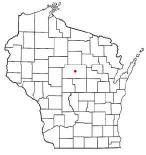
Marathon County is a county located in the U.S. state of Wisconsin. As of the 2020 census, the population was 138,013. Its county seat is Wausau. It was founded in 1850, created from a portion of Portage County. At that time the county stretched to the northern border with the upper Michigan peninsula. It is named after the battlefield at Marathon, Greece.

<span class="mw-page-title-main">Athens, Wisconsin</span> Village in Wisconsin, United States

Athens is a village in Marathon County, Wisconsin, United States. The population was 1,105 at the 2010 census. It is part of the Wausau, Wisconsin Metropolitan Statistical Area.

<span class="mw-page-title-main">Brighton, Marathon County, Wisconsin</span> Town in Wisconsin, United States

Brighton is a town in Marathon County, Wisconsin, United States. It is part of the Wausau, Wisconsin Metropolitan Statistical Area. The population was 620 at the 2020 census.

<span class="mw-page-title-main">Brokaw, Wisconsin</span> Village in Wisconsin, United States

Brokaw is a former village in Marathon County, Wisconsin, United States. It is part of the Wausau, Wisconsin Metropolitan Statistical Area. The population was 251 at the 2010 census. Brokaw merged with the village of Maine, Wisconsin on October 1, 2018.

<span class="mw-page-title-main">Edgar, Wisconsin</span> Village in Wisconsin, United States

Edgar is a village in Marathon County, Wisconsin, United States. It is part of the Wausau, Wisconsin Metropolitan Statistical Area. The population was 1,479 at the 2010 census. Edgar has maintained Tree City USA standing since 1995.

<span class="mw-page-title-main">Fenwood, Wisconsin</span> Village in Wisconsin, United States

Fenwood is a village in Marathon County, Wisconsin, United States. It is part of the Wausau, Wisconsin Metropolitan Statistical Area. The population was 152 at the 2010 census.

<span class="mw-page-title-main">Guenther, Wisconsin</span> Town in Wisconsin, United States

Guenther is a town in Marathon County, Wisconsin, United States. It is part of the Wausau, Wisconsin Metropolitan Statistical Area. The population was 341 at the 2010 census. The unincorporated communities of Ashley and Rocky Corners are located partially in the town.

<span class="mw-page-title-main">Hatley, Wisconsin</span> Village in Wisconsin, United States

Hatley is a village in Marathon County, Wisconsin, United States. It is part of the Wausau, Wisconsin Metropolitan Statistical Area. The population was 574 at the 2010 census.

<span class="mw-page-title-main">Marathon, Wisconsin</span> Town in Wisconsin, United States

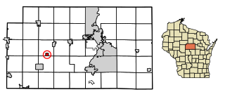
Marathon is a town in Marathon County, Wisconsin, United States. It is part of the Wausau, Wisconsin Metropolitan Statistical Area. The population was 1,048 at the 2010 census. The village of Marathon City was incorporated from a part of the town's original area.

<span class="mw-page-title-main">Marathon City, Wisconsin</span> Village in Wisconsin, United States

Marathon City is a village in Marathon County, Wisconsin, United States. It is part of the Wausau, Wisconsin Metropolitan Statistical Area. The population was 1,524 at the 2010 census. The village was incorporated from a part of the original area of the town of Marathon. The village dates back to 1856. The name of the village commemorates the Battle of Marathon.

<span class="mw-page-title-main">Schofield, Wisconsin</span> City in Wisconsin, United States

Schofield is a city in Marathon County, Wisconsin, United States. It is part of the Wausau, Wisconsin Metropolitan Statistical Area. The population was 2,157 at the 2020 census. The city was named for William Scholfield, who came to the area in the 1851 to open a sawmill. The city has since dropped the "L" from its name.

<span class="mw-page-title-main">Stettin, Wisconsin</span> Town in Wisconsin, United States

Stettin is a town in Marathon County, Wisconsin, United States. It is part of the Wausau, Wisconsin Metropolitan Statistical Area. The population was 2,554 at the 2010 census. The unincorporated community of Mount View is located partially in the town.

<span class="mw-page-title-main">Stratford, Wisconsin</span> Village in Wisconsin, United States

Stratford is a village in Marathon County, Wisconsin, United States. It is part of the Wausau, Wisconsin Metropolitan Statistical Area. The population was 1,578 at the 2010 census.

<span class="mw-page-title-main">Wien, Wisconsin</span> Town in Wisconsin, United States

Wien is a town in Marathon County, Wisconsin, United States. It is part of the Wausau, Wisconsin Metropolitan Statistical Area. The population was 825 at the 2010 census. The unincorporated community of Wien is located in the town.

<span class="mw-page-title-main">Dorchester, Wisconsin</span> Village in Wisconsin, United States

Dorchester is a village in Clark and Marathon counties in the U.S. state of Wisconsin, along the 45th parallel. It is part of the Wausau, Wisconsin Metropolitan Statistical Area. The population was 876 at the 2010 census. Of this, 871 were in Clark County, and only 5 were in Marathon County.

<span class="mw-page-title-main">Birnamwood, Wisconsin</span> Village in Wisconsin, United States

Birnamwood is a village in Marathon and Shawano counties in the U.S. state of Wisconsin. It is part of the Wausau, Wisconsin Metropolitan Statistical Area. The population was 818 at the 2010 census. Of this, 802 were in Shawano County, and 16 were in Marathon County. The village is located mostly within the town of Birnamwood in Shawano County; only a small portion extends into the town of Norrie in adjacent Marathon County.

<span class="mw-page-title-main">Unity, Wisconsin</span> Village in Wisconsin, United States

Unity is a village in Clark and Marathon counties in the U.S. state of Wisconsin. It is part of the Wausau, Wisconsin Metropolitan Statistical Area. The population was 343 at the 2010 census. Of this, 204 were in Marathon County, and 139 were in Clark County. The village is located in northeastern town of Unity in Clark County and northwestern town of Brighton in Marathon County.

Elderon is a town in Marathon County, Wisconsin, United States. It is part of the Wausau, Wisconsin Metropolitan Statistical Area. The population was 606 at the 2010 census. The unincorporated community of Ingersoll is located in the town.

<span class="mw-page-title-main">Rib Mountain, Wisconsin</span> Village in Wisconsin, United States

Rib Mountain is a village located in Marathon County, Wisconsin, United States. The population was 7,313 at the 2020 census. A suburb of Wausau, it is part of the Wausau Metropolitan Statistical Area. The census-designated place of Rib Mountain is located in the village.

The Town of Weston is located in Marathon County, Wisconsin, United States. It is part of the Wausau, Wisconsin Metropolitan Statistical Area. The population was 657 at the 2020 census.

References

  1. "2019 U.S. Gazetteer Files". United States Census Bureau. Retrieved August 7, 2020.
  2. 1 2 "US Board on Geographic Names". United States Geological Survey. October 25, 2007. Retrieved January 31, 2008.
  3. 1 2 "U.S. Census website". United States Census Bureau . Retrieved January 31, 2008.
  4. "United States Census 2020". United States Census Bureau . Retrieved March 3, 2023.
  5. "US Gazetteer files: 2010, 2000, and 1990". United States Census Bureau. February 12, 2011. Retrieved April 23, 2011.
  6. "US Gazetteer files 2010". United States Census Bureau. Archived from the original on July 2, 2012. Retrieved November 18, 2012.
  7. "Census of Population and Housing". Census.gov. Retrieved June 4, 2015.
  8. "U.S. Census website". United States Census Bureau . Retrieved November 18, 2012.