
A plough or plow is a farm tool for loosening or turning the soil before sowing seed or planting. Ploughs were traditionally drawn by oxen and horses but in modern farms are drawn by tractors. A plough may have a wooden, iron or steel frame with a blade attached to cut and loosen the soil. It has been fundamental to farming for most of history. The earliest ploughs had no wheels; such a plough was known to the Romans as an aratrum. Celtic peoples first came to use wheeled ploughs in the Roman era.

The Highlands is a historical region of Scotland. Culturally, the Highlands and the Lowlands diverged from the Late Middle Ages into the modern period, when Lowland Scots language replaced Scottish Gaelic throughout most of the Lowlands. The term is also used for the area north and west of the Highland Boundary Fault, although the exact boundaries are not clearly defined, particularly to the east. The Great Glen divides the Grampian Mountains to the southeast from the Northwest Highlands. The Scottish Gaelic name of A' Ghàidhealtachd literally means "the place of the Gaels" and traditionally, from a Gaelic-speaking point of view, includes both the Western Isles and the Highlands.
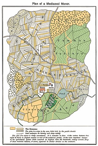
The open-field system was the prevalent agricultural system in much of Europe during the Middle Ages and lasted into the 20th century in Russia, Iran, and Turkey. Each manor or village had two or three large fields, usually several hundred acres each, which were divided into many narrow strips of land. The strips or selions were cultivated by peasants, often called tenants or serfs. The holdings of a manor also included woodland and pasture areas for common usage and fields belonging to the lord of the manor and the religious authorities, usually Roman Catholics in medieval Western Europe. The farmers customarily lived in separate houses in a nucleated village with a much larger manor house and church nearby. The open-field system necessitated co-operation among the residents of the manor.

The Agricultural Revolution in Scotland was a series of changes in agricultural practice that began in the 17th century and continued in the 19th century. They began with the improvement of Scottish Lowlands farmland and the beginning of a transformation of Scottish agriculture from one of the least modernised systems to what was to become the most modern and productive system in Europe. The traditional system of agriculture in Scotland generally used the runrig system of management, which had possibly originated in the Late Middle Ages. The basic pre-improvement farming unit was the baile and the fermetoun. In each, a small number of families worked open-field arable and shared grazing. Whilst run rig varied in its detail from place to place, the common defining detail was the sharing out by lot on a regular basis of individual parts ("rigs") of the arable land so that families had intermixed plots in different parts of the field.

The first Highland Land League emerged as a distinct political force in Scotland during the 1880s, with its power base in the country's Highlands and Islands. It was known also as the Highland Land Law Reform Association and the Crofters' Party. It was consciously modelled on the Irish Land League.
A lynchet or linchet is an earth terrace found on the side of a hill. Lynchets are a feature of ancient field systems of the British Isles. They are commonly found in vertical rows and more commonly referred to as "strip lynchets". Lynchets appear predominantly in Southern Britain and many are in areas close to Iron Age forts and other earthworks, including later Roman earthworks and earlier barrows from the Neolithic and Bronze Age periods. The size, location, spacing and number of rows of many strip lynchets indicates that many were man-made. It is most likely that lynchets were dug to maximise the use of land for agriculture, although they may have had other, ceremonial uses.

Agriculture in the Russian Empire throughout the 19th-20th centuries Russia represented a major world force, yet it lagged technologically behind other developed countries. Imperial Russia was amongst the largest exporters of agricultural produce, especially wheat. The Free Economic Society of 1765 to 1919 made continuing efforts to improve farming techniques.

Ridge and furrow is an archaeological pattern of ridges and troughs created by a system of ploughing used in Europe during the Middle Ages, typical of the open-field system. It is also known as rigand furrow, mostly in the North East of England and in Scotland.

Lazy bed is a traditional method of arable cultivation. Rather like cord rig cultivation, parallel banks of ridge and furrow are dug by spade although lazy beds have banks that are bigger, up to 2.5 metres in width, with narrow drainage channels between them. It was used in southern parts of Britain from the post-Roman period until the post-medieval period, and across much of Ireland and Scotland until the 19th century.

Crofting is a form of land tenure and small-scale food production particular to the Scottish Highlands, the islands of Scotland, and formerly on the Isle of Man. Within the 19th-century townships, individual crofts were established on the better land, and a large area of poorer-quality hill ground was shared by all the crofters of the township for grazing of their livestock. In the 21st century, crofting is found predominantly in the rural Western and Northern Isles and in the coastal fringes of the western and northern Scottish mainland.
The Napier Commission, officially the Royal Commission of Inquiry into the Condition of Crofters and Cottars in the Highlands and Islands was a royal commission and public inquiry into the condition of crofters and cottars in the Highlands and Islands of Scotland.

A croft is a traditional Scottish term for a fenced or enclosed area of land, usually small and arable, and usually, but not always, with a crofter's dwelling thereon. A crofter is one who has tenure and use of the land, typically as a tenant farmer, especially in rural areas.

The rundale system was a form of occupation of land in Ireland, somewhat resembling the English common field system. The land is divided into discontinuous plots, and cultivated and occupied by a number of tenants to whom it is leased jointly. The system was common in Ireland, especially in the western counties. In Scotland, where the system also existed, it was termed run rig.
The study of field systems in landscape history is concerned with the size, shape and orientation of a number of fields. These are often adjacent, but may be separated by a later feature.

Agriculture in Scotland includes all land use for arable, horticultural or pastoral activity in Scotland, or around its coasts. The first permanent settlements and farming date from the Neolithic period, from around 6,000 years ago. From the beginning of the Bronze Age, about 2000 BCE, arable land spread at the expense of forest. From the Iron Age, beginning in the seventh century BCE, there was use of cultivation ridges and terraces. During the period of Roman occupation there was a reduction in agriculture and the early Middle Ages were a period of climate deterioration resulting in more unproductive land. Most farms had to produce a self-sufficient diet, supplemented by hunter-gathering. More oats and barley were grown, and cattle were the most important domesticated animal. From c. 1150 to 1300, the Medieval Warm Period allowed cultivation at greater heights and made land more productive. The system of infield and outfield agriculture may have been introduced with feudalism from the twelfth century. The rural economy boomed in the thirteenth century, but by the 1360s there was a severe falling off in incomes to be followed by a slow recovery in the fifteenth century.

The Highland Clearances were the forced evictions of a significant number of tenants in the Scottish Highlands and Islands, mostly in two phases from 1750 to 1860.

Glendale is a community-owned estate on the north-western coastline of the Duirinish peninsula on the island of Skye and is in the Scottish council area of Highland. The estate encompasses the small crofting townships of Skinidin, Colbost, Fasach, Glasphein, Holmisdale, Lephin, Hamaraverin, Borrodale, Milovaig, Waterstein, Feriniquarrie, Totaig, Hamara, and others.

The history of agriculture in Scotland includes all forms of farm production in the modern boundaries of Scotland, from the prehistoric era to the present day.

Agriculture in Scotland in the Middle Ages includes all forms of farm production in the modern boundaries of Scotland, between the departure of the Romans from Britain in the fifth century and the establishment of the Renaissance in the early sixteenth century. Scotland has between a fifth and a sixth of the amount of the arable or good pastoral land of England and Wales, mostly located in the south and east. Heavy rainfall encouraged the spread of acidic blanket peat bog, which with wind and salt spray, made most of the western islands treeless. The existence of hills, mountains, quicksands and marshes made internal communication and agriculture difficult. Most farms had to produce a self-sufficient diet of meat, dairy products and cereals, supplemented by hunter-gathering. The early Middle Ages were a period of climate deterioration resulting in more land becoming unproductive. Farming was based around a single homestead or a small cluster of three or four homes, each probably containing a nuclear family and cattle were the most important domesticated animal.
Agriculture in Scotland in the early modern era includes all forms of farm production in the modern boundaries of Scotland, between the establishment of the Renaissance in the early sixteenth century and the beginning of the Industrial Revolution in the mid-eighteenth century. This era saw the impact of the Little Ice Age, which peaked towards the end of the seventeenth century. Almost half the years in the second half of the sixteenth century saw local or national scarcity, necessitating the shipping of large quantities of grain from the Baltic. In the early seventeenth century famine was relatively common, but became rarer as the century progressed. The closing decade of the seventeenth century saw a slump, followed by four years of failed harvests, in what is known as the "seven ill years", but these shortages would be the last of their kind.
