Rupert, Idaho

Last updated

Rupert, Idaho
Wilsontheatrerupertidaho.JPG
Wilson Theatre in downtown Rupert in 2006
Minidoka County Idaho Incorporated and Unincorporated areas Rupert Highlighted 1670660.svg
Location in Minidoka County, Idaho
Usa edcp location map.svg
Red pog.svg
Rupert, Idaho
Location in the contiguous United States
Coordinates: 42°37′5″N113°40′28″W / 42.61806°N 113.67444°W / 42.61806; -113.67444
Country United States
State Idaho
County Minidoka
Government
  City SuperintendentDennis Andrew
Area
[1]
  Total2.06 sq mi (5.33 km2)
  Land2.06 sq mi (5.33 km2)
  Water0.00 sq mi (0.00 km2)
Elevation
4,157 ft (1,267 m)
Population
 (2020) [2]
  Total6,082
  Density2,953.9/sq mi (1,140.5/km2)
Time zone UTC-7 (Mountain (MST))
  Summer (DST) UTC-6 (MDT)
ZIP codes
83343, 83350
Area code(s) 208, 986
FIPS code 16-70660
GNIS feature ID0374811
Website www.rupert-idaho.com

Rupert is the county seat and largest city of Minidoka County, Idaho. [3] It is part of the Burley Micropolitan Statistical Area. The population was 6,082 at the 2020 census, [2] up from 5,554 in 2010. [4]

Contents

Rupert, founded in 1906, sprang up after the announcement of the Minidoka Reclamation Project, which provided irrigation and electricity following the completion of the Minidoka Dam on the Snake River in 1906. After the dam was built, Rupert became one of the first cities in the world to have its streets lit by electricity.[ citation needed ]

Geography

Rupert is located in southern Minidoka County at an elevation of 4,157 feet (1,267 m) above sea level. [5] It is part of the agricultural region of the Snake River Plain known as Magic Valley, and is 3 miles (5 km) northwest of the Snake River. Interstate 84 passes 5 miles (8 km) to the south, and before its construction, U.S. Route 30 passed through Rupert. Acequia lies about 5 miles (8 km) northeast of Rupert and Jackson is about 4 miles (6 km) east of Rupert on the Snake River of Minidoka County and Cassia County of Idaho and Paul is about the same distance to the west.

According to the United States Census Bureau, Rupert has a total area of 2.06 square miles (5.34 km2), all of it land. [1]

Climate

These data are from the Western Regional Climate Center, compiled over the years 1906 to 2002. [6]

Climate data for Rupert, ID
MonthJanFebMarAprMayJunJulAugSepOctNovDecYear
Record high °F (°C)61
(16)
70
(21)
79
(26)
89
(32)
99
(37)
103
(39)
104
(40)
104
(40)
99
(37)
91
(33)
82
(28)
70
(21)
104
(40)
Mean daily maximum °F (°C)34.5
(1.4)
40.2
(4.6)
50.6
(10.3)
61.3
(16.3)
69.7
(20.9)
78.7
(25.9)
88.1
(31.2)
86.9
(30.5)
76.6
(24.8)
64.7
(18.2)
48.1
(8.9)
37.3
(2.9)
61.4
(16.3)
Mean daily minimum °F (°C)14.3
(−9.8)
19.8
(−6.8)
26.1
(−3.3)
32.3
(0.2)
39.8
(4.3)
47.0
(8.3)
53.2
(11.8)
50.9
(10.5)
41.7
(5.4)
33.0
(0.6)
24.2
(−4.3)
16.9
(−8.4)
33.3
(0.7)
Record low °F (°C)−34
(−37)
−31
(−35)
−8
(−22)
5
(−15)
20
(−7)
30
(−1)
34
(1)
24
(−4)
17
(−8)
11
(−12)
−11
(−24)
−27
(−33)
−34
(−37)
Average precipitation inches (mm)1.08
(27)
0.84
(21)
0.90
(23)
0.86
(22)
1.03
(26)
0.85
(22)
0.35
(8.9)
0.35
(8.9)
0.57
(14)
0.79
(20)
0.95
(24)
0.97
(25)
9.54
(241.8)
Average snowfall inches (cm)7.3
(19)
4.2
(11)
2.4
(6.1)
0.8
(2.0)
0.2
(0.51)
0
(0)
0
(0)
0
(0)
0
(0)
0.2
(0.51)
1.3
(3.3)
4.1
(10)
20.5
(52.42)
Source: https://wrcc.dri.edu/cgi-bin/cliMAIN.pl?id7968

Demographics

Historical population
CensusPop.Note
1910 297
1920 2,372698.7%
1930 2,250−5.1%
1940 3,16740.8%
1950 3,098−2.2%
1960 4,15334.1%
1970 4,5639.9%
1980 5,47620.0%
1990 5,455−0.4%
2000 5,6453.5%
2010 5,554−1.6%
2020 6,0829.5%
U.S. Decennial Census [7]

2010 census

As of the census [8] of 2010, there were 5,554 people, 2,026 households, and 1,397 families living in the city. The population density was 2,657.4 inhabitants per square mile (1,026.0/km2). There were 2,186 housing units at an average density of 1,045.9 per square mile (403.8/km2). The racial makeup of the city was 75.0% White, 0.3% African American, 1.6% Native American, 0.4% Asian, 20.1% from other races, and 2.6% from two or more races. Hispanic or Latino of any race were 42.9% of the population.

There were 2,026 households, of which 38.8% had children under the age of 18 living with them, 49.0% were married couples living together, 14.1% had a female householder with no husband present, 5.8% had a male householder with no wife present, and 31.0% were non-families. 26.8% of all households were made up of individuals, and 14.2% had someone living alone who was 65 years of age or older. The average household size was 2.71 and the average family size was 3.30.

The median age in the city was 33.3 years. 30.4% of residents were under the age of 18; 9.6% were between the ages of 18 and 24; 23.2% were from 25 to 44; 21.8% were from 45 to 64; and 15% were 65 years of age or older. The gender makeup of the city was 49.0% male and 51.0% female.

2000 census

As of the census [9] of 2000, there were 5,645 people, 2,024 households, and 1,443 families living in the city. The population density was 2,779.9 inhabitants per square mile (1,073.3/km2). There were 2,204 housing units at an average density of 1,085.4 per square mile (419.1/km2). The racial makeup of the city was 72.65% White, 0.37% African American, 1.17% Native American, 0.32% Asian, 0.02% Pacific Islander, 22.69% from other races, and 2.78% from two or more races. Hispanic or Latino of any race were 35.39% of the population.

There were 2,024 households, out of which 38.3% had children under the age of 18 living with them, 54.5% were married couples living together, 12.5% had a female householder with no husband present, and 28.7% were non-families. 25.2% of all households were made up of individuals, and 12.7% had someone living alone who was 65 years of age or older. The average household size was 2.75 and the average family size was 3.31.

In the city, the population was spread out, with 31.2% under the age of 18, 10.6% from 18 to 24, 25.0% from 25 to 44, 18.8% from 45 to 64, and 14.3% who were 65 years of age or older. The median age was 32 years. For every 100 females, there were 90.8 males. For every 100 females age 18 and over, there were 86.7 males.

The median income for a household in the city was $25,105, and the median income for a family was $29,423. Males had a median income of $28,070 versus $16,779 for females. The per capita income for the city was $12,253. About 18.9% of families and 21.5% of the population were below the poverty line, including 29.2% of those under age 18 and 11.7% of those age 65 or over.

Rupert City Hall Rupert City Hall.jpg
Rupert City Hall

Education

Rupert is served by the Minidoka County Schools system. [10]

Children are zoned to:

DeMary Memorial Library is the area library. [11]

The county is in the catchment area, but not the taxation zone, for College of Southern Idaho. [12]

Notable people

Related Research Articles

<span class="mw-page-title-main">Nez Perce County, Idaho</span> County in Idaho, United States

Nez Perce County is a county located in the U.S. state of Idaho. As of the 2020 census, the population was 42,090. The county seat is Lewiston. The county is named after the Native American Nez Perce tribe. Nez Perce County is part of the Lewiston, Idaho–WA Metropolitan Statistical Area.

<span class="mw-page-title-main">Twin Falls County, Idaho</span> County in Idaho, United States

Twin Falls County is a county in the south central part of the U.S. state of Idaho. As of the 2020 census, the population was 90,046, making it the fifth-most populous county in Idaho. The county seat and largest city is Twin Falls. Twin Falls County is part of the Twin Falls, ID Twin Falls Metropolitan Statistical Area.

<span class="mw-page-title-main">Power County, Idaho</span> County in Idaho, United States

Power County is a county located in the U.S. state of Idaho. As of the 2020 Census, the county had a population of 7,878. The county seat and largest city is American Falls. The county was created by the Idaho Legislature on January 30, 1913, by a partition of Cassia County. It is named for an early hydroelectric power plant (1902) at the American Falls.

<span class="mw-page-title-main">Minidoka County, Idaho</span> County in Idaho, United States

Minidoka County is a county located in the U.S. state of Idaho. As of the 2020 census, the population was 21,613. The county seat and largest city is Rupert.

<span class="mw-page-title-main">Lincoln County, Idaho</span> County in Idaho, United States

Lincoln County is a county located in the U.S. state of Idaho. As of the 2020 census, the population was 5,127. The county seat and largest city is Shoshone. The county is named after President Abraham Lincoln. The Idaho Territory was created in 1863, during the Lincoln Administration of 1861–65.

<span class="mw-page-title-main">Jerome County, Idaho</span> County in Idaho, United States

Jerome County is a county in the U.S. state of Idaho. As of the 2020 Census the county had a population of 24,237. The county seat and largest city is Jerome. The county was created by the Idaho Legislature on February 8, 1919, by a partition of Lincoln County. It was named after either Jerome Hill, a developer of the North Side Irrigation Project, his son-in-law Jerome Kuhn, or his grandson Jerome Kuhn, Jr.

<span class="mw-page-title-main">Gooding County, Idaho</span> County in Idaho, United States

Gooding County is a county located in the U.S. state of Idaho. As of the 2020 census, the population was 15,598. Its county seat is Gooding. The county was created by the Idaho Legislature on January 28, 1913, by a partition of Lincoln County. It is named for Frank R. Gooding, the 7th governor and a United States Senator from Idaho.

<span class="mw-page-title-main">Blaine County, Idaho</span> County in Idaho, United States

Blaine County is a county in the U.S. state of Idaho. As of the 2020 United States Census, the population was 24,272. The county seat and largest city is Hailey. It is also home to the Sun Valley ski resort, adjacent to Ketchum.

<span class="mw-page-title-main">Eagle, Idaho</span> City in Idaho, United States

Eagle is a city in Ada County, Idaho 10 miles (16 km) northwest of Boise. The population was 30,346 at the 2020 census.

<span class="mw-page-title-main">Firth, Idaho</span> City in Bingham County, Idaho, United States

Firth is a city in Bingham County, Idaho, United States. The population was 517 at the 2020 census.

<span class="mw-page-title-main">Arco, Idaho</span> City in Idaho, United States

Arco is a city in Butte County, Idaho, United States. The population was 879 as of the 2020 United States census, down from 995 at the 2010 census. Arco is the county seat and largest city in Butte County.

<span class="mw-page-title-main">Menan, Idaho</span> City in Idaho, United States

Menan is a city in Jefferson County, Idaho, United States. It is part of the Idaho Falls, Idaho Metropolitan Statistical Area. The population was 741 at the 2010 census.

<span class="mw-page-title-main">Acequia, Idaho</span> City in Idaho, United States

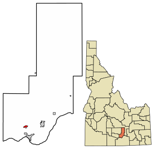
Acequia is a city in Minidoka County, Idaho, United States. The population was 131 at the 2020 census. It is part of the Burley, Idaho Micropolitan Statistical Area. The town is named for the Spanish word for canal.

<span class="mw-page-title-main">Heyburn, Idaho</span> City in Idaho, United States

Heyburn is a city in Minidoka County, Idaho, United States. The population was 3,700 at the 2020 census, up from 3,089 in 2010. It is part of the Burley micropolitan area.

<span class="mw-page-title-main">Minidoka, Idaho</span> City in Idaho, United States

Minidoka is a city in Minidoka County, Idaho, United States. The population was 86 at the 2020 census, down from 112 in 2010. It is part of the Burley, Idaho Micropolitan Statistical Area.

<span class="mw-page-title-main">Paul, Idaho</span> City in Idaho, United States

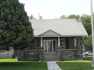
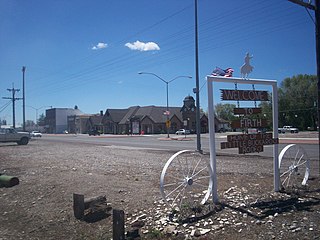
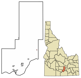
Paul is a city in Minidoka County, Idaho, United States. founded in 1907. The population was 1,195 at the 2020 census. It is part of the Burley, Idaho Micropolitan Statistical Area. The town received its name from Charles H. Paul, an engineer who worked on the Minidoka Project.

<span class="mw-page-title-main">Grand View, Idaho</span> City in Owyhee County, Idaho, United States

Grand View is a city along the Snake River in Owyhee County, Idaho, United States. The population was 440 at the 2020 census. It is part of the Boise City–Nampa, Idaho Metropolitan Statistical Area.

<span class="mw-page-title-main">Marsing, Idaho</span> City in Owhyee County, Idaho, United States

Marsing is a city in Owyhee County, Idaho, United States. The population was 1,031 at the time of the 2010 census. It is part of the Boise metropolitan area.

<span class="mw-page-title-main">Fruitland, Idaho</span> City in Payette County, Idaho, United States

Fruitland is a city along the Snake and Payette rivers in Payette County, Idaho, United States. It lies along U.S. Route 95 in the Treasure Valley of southwest Idaho, about 50 miles (80 km) west of Boise on the border with Oregon. It is part of the Ontario Micropolitan Area. Fruitland is named after apple orchards that surround the community, and its slogan is "The Big Apple of Idaho."

<span class="mw-page-title-main">Cambridge, Idaho</span> City in Idaho, United States

Cambridge is a city in Washington County, Idaho, United States. The population was 328 at the 2010 census, down from 360 in 2000. It is the second largest city in the county, behind the significantly larger Weiser, the county seat.

References

  1. 1 2 "2022 U.S. Gazetteer Files: Idaho". United States Census Bureau. Retrieved February 3, 2023.
  2. 1 2 "P1. Race – Rupert city, Idaho: 2020 DEC Redistricting Data (PL 94-171)". U.S. Census Bureau. Retrieved February 3, 2023.
  3. "Find a County". National Association of Counties. Retrieved June 7, 2011.
  4. quickfacts.census.gov Rupert, Idaho Archived 2012-01-20 at the Wayback Machine , U.S. Census Bureau, 2010. Accessed 2011-12-11.
  5. "US Gazetteer files: 2010, 2000, and 1990". United States Census Bureau. February 12, 2011. Retrieved April 23, 2011.
  6. "RUPERT 3 WSW, IDAHO - Climate Summary". wrcc.dri.edu. Retrieved January 3, 2018.
  7. "Census of Population and Housing". Census.gov. Retrieved June 4, 2015.
  8. "U.S. Census website". United States Census Bureau . Retrieved December 18, 2012.
  9. "U.S. Census website". United States Census Bureau . Retrieved January 31, 2008.
  10. "2020 CENSUS - SCHOOL DISTRICT REFERENCE MAP: Minidoka County, ID" (PDF). U.S. Census Bureau . Retrieved March 12, 2024. - Text list
  11. "Home". DeMary Memorial Library. Retrieved March 13, 2024.
  12. "Community Colleges" (PDF). Legislative Budget Book. Idaho Legislature. 2016. p. 1-81 (PDF p. 3/9). - See area 1 in: "TITLE 33 EDUCATION CHAPTER 21 JUNIOR COLLEGES". Idaho Legislature . Retrieved March 12, 2024.