S.O.B. Hill

Last updated

S.O.B. Hill is a 5,866-foot (1,788 m), [1] summit in San Juan County, Utah, in the United States.

San Juan County, Utah county in Utah, Untied States

San Juan County is a county located in the southeastern portion of the U.S. state of Utah. As of the 2010 census, the population was 14,746. Its county seat is Monticello, while its most populous city is Blanding. The county was named by the Utah State Legislature for the San Juan River, itself named by Spanish explorers.

United States federal republic in North America

The United States of America (USA), commonly known as the United States or America, is a country composed of 50 states, a federal district, five major self-governing territories, and various possessions. At 3.8 million square miles, the United States is the world's third or fourth largest country by total area and is slightly smaller than the entire continent of Europe's 3.9 million square miles. With a population of over 327 million people, the U.S. is the third most populous country. The capital is Washington, D.C., and the largest city by population is New York City. Forty-eight states and the capital's federal district are contiguous in North America between Canada and Mexico. The State of Alaska is in the northwest corner of North America, bordered by Canada to the east and across the Bering Strait from Russia to the west. The State of Hawaii is an archipelago in the mid-Pacific Ocean. The U.S. territories are scattered about the Pacific Ocean and the Caribbean Sea, stretching across nine official time zones. The extremely diverse geography, climate, and wildlife of the United States make it one of the world's 18 megadiverse countries.

A trail for off-road vehicles passes over S.O.B. Hill and leads to a small public campground. [2]

Off-road vehicle

An off-road vehicle is considered to be any type of vehicle which is capable of driving on and off paved or gravel surface. It is generally characterized by having large tires with deep, open treads, a flexible suspension, or even caterpillar tracks. Other vehicles that do not travel public streets or highways are generally termed off-highway vehicles, including tractors, forklifts, cranes, backhoes, bulldozers, and golf carts.

S.O.B. Hill has been noted for its unusual place name. [3]

Place names considered unusual Wikimedia list article

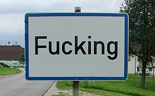
Unusual place names are names for cities, towns, and other regions which are considered non-ordinary in some manner. This can include place names which are also swear words, inadvertently humorous or highly charged words, as well as place names of unorthodox spelling and pronunciation, including especially short or long names.

Related Research Articles

January 1 is the first day of the year in the Gregorian Calendar. There are 364 days remaining until the end of the year. This day is known as New Year's Day since the day marks the beginning of the year. It is also the first day of the first quarter of the year and the first half of the year.

Beverly Hills, California City in California

Beverly Hills is a city located in Los Angeles County, California, United States. Beverly Hills is surrounded by the cities of Los Angeles and West Hollywood.

Adams–Onís Treaty treaty between the United States and Spain, ceding Florida to the U.S.

The Adams–Onís Treaty of 1819, also known as the Transcontinental Treaty, the Florida Purchase Treaty, or the Florida Treaty, was a treaty between the United States and Spain in 1819 that ceded Florida to the U.S. and defined the boundary between the U.S. and New Spain. It settled a standing border dispute between the two countries and was considered a triumph of American diplomacy. It came in the midst of increasing tensions related to Spain's territorial boundaries in North America against the United States and Great Britain in the aftermath of the American Revolution; it also came during the Latin American wars of independence.

Coteau du Missouri geographic region

The Coteau du Missouri, or Missouri Plateau, is a large plateau that stretches along the eastern side of the valley of the Missouri River in central North Dakota and north-central South Dakota in the United States. In the Canadian provinces of Saskatchewan and Alberta this physiographic region is classified as the uplands Missouri Coteau, which is a part of the Great Plains Province or Alberta Plateau Region, which extends across the southwest corner of the province of Saskatchewan as well as the southeast corner of the province of Alberta. Historically, in Canada the area was known as the Palliser's Triangle regarded as an extension of the Great American Desert and unsuitable for agriculture and thus designated by Canadian geographer and explorer John Palliser. The terrain of the Missouri Coteau features low hummocky, undulating, rolling hills, potholes, and grasslands.

Zuni River river in the United States of America

The Zuni (Zuñi) River is a tributary of the Little Colorado River in the southwestern United States. It has its origin in Cibola County, New Mexico, in the Zuñi Mountains at the Continental Divide. The river flows off the western slopes of the Zuñi Mountains in a generally southwesterly direction through the Zuni Indian Reservation to join the Little Colorado River in eastern Arizona. The Zuni River is approximately 90 miles (140 km) long, and has a drainage basin in New Mexico of approximately 1,300 square miles (3,400 km2).

Forest Hill, Indiana Unincorporated community in Indiana, United States

Forest Hill is an unincorporated community in Jackson Township, Decatur County, Indiana.

Dover Hill, Indiana Census-designated place in Indiana, United States

Dover Hill is an unincorporated census-designated place in Center Township, Martin County, in the U.S. state of Indiana.

Bono, Vermillion County, Indiana Unincorporated community in Indiana, United States

Bono is an unincorporated community in Helt Township, Vermillion County, in the U.S. state of Indiana.

Bold Orion experimental air-launched ballistic missile, U.S. Air Force, 1958

The Bold Orion missile, also known as Weapons System 199B (WS-199B), was a prototype air-launched ballistic missile (ALBM) developed by Martin Aircraft during the 1950s. Developed in both one- and two-stage designs, the missile was moderately successful in testing, and helped pave the way for development of the GAM-87 Skybolt ALBM. In addition, the Bold Orion was used in early anti-satellite weapons testing, performing the first interception of a satellite by a missile.

Timeline of events leading to the American Civil War

This timeline of events leading up to the American Civil War describes and links to narrative articles and references about many of the events and issues which historians recognize as origins and causes of the Civil War. The pre-Civil War events can be roughly divided into a period encompassing the long-term build-up over many decades and a period encompassing the five-month build-up to war immediately after the election of Abraham Lincoln as President in the Election of 1860, which culminated in the Fall of Fort Sumter.

Chapel Hill, Indiana Unincorporated community in Indiana, United States

Chapel Hill is an unincorporated community in Polk Township, Monroe County, in the U.S. state of Indiana.

Silver Hills is an unincorporated community in Floyd County, Indiana, in the United States.

Marble Hill is an unincorporated community in Jefferson County, Indiana, in the United States.

This article is about a place in Indiana. For other articles referring to Dark Hollow, see the article Dark Hollow.

Eureka is an unincorporated community in Lawrence County, Indiana, in the United States.

Red Hill is an unincorporated community in Lawrence County, Indiana, in the United States.

The Phallus is a rock formation (pillar) in Grand County, Utah, in the United States. It is within the Arches National Park.

Bunker Hill, Washington County, Indiana Unincorporated community in Indiana, United States

Bunker Hill is an unincorporated community in Franklin Township, Washington County, in the U.S. state of Indiana.

References

  1. "S.O.B. Hill". Geographic Names Information System . United States Geological Survey . Retrieved 2016-04-22.
  2. Schneider, Bill (15 April 2005). Canyonlands and Arches National Park. Globe Pequot Press. p. 155. ISBN   978-0-7627-2540-3.
  3. Monmonier, Mark (15 September 2008). From Squaw Tit to Whorehouse Meadow: How Maps Name, Claim, and Inflame. University of Chicago Press. p. 70. ISBN   978-0-226-53464-0.

Coordinates: 38°07′14″N109°51′42″W / 38.1205426°N 109.8617921°W / 38.1205426; -109.8617921

Geographic coordinate system Coordinate system

A geographic coordinate system is a coordinate system that enables every location on Earth to be specified by a set of numbers, letters or symbols. The coordinates are often chosen such that one of the numbers represents a vertical position and two or three of the numbers represent a horizontal position; alternatively, a geographic position may be expressed in a combined three-dimensional Cartesian vector. A common choice of coordinates is latitude, longitude and elevation. To specify a location on a plane requires a map projection.