
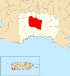
Lajas is a municipality of Puerto Rico located in southwestern Puerto Rico, on the southern coast of the island, bordering the Caribbean Sea, south of San Germán and Sabana Grande; east of Cabo Rojo; and west of Guánica. Lajas is spread over 11 barrios plus Lajas Pueblo. It is part of the San Germán-Cabo Rojo Metropolitan Statistical Area.

San Juan Province is a province of Argentina, located in the western part of the country. Neighbouring provinces are, moving clockwise from the north, La Rioja, San Luis and Mendoza. It borders with Chile to the west.

Sabana Grande is a municipality of Puerto Rico located north of Lajas and Guánica; south of Maricao; east of San Germán; and west of Yauco. Sabana Grande is spread over seven barrios and Sabana Grande Pueblo. It is part of the San Germán-Cabo Rojo Metropolitan Statistical Area.

Trujillo Alto is a municipality of Puerto Rico located in the Northern Coastal Plain and in the karst zone, north of Caguas, and Gurabo; southeast of San Juan, and west of Carolina. Trujillo Alto is part of the San Juan Metropolitan Area, which includes the municipalities of Bayamón, Guaynabo, Cataño, and Toa Baja. The city is spread over 6 barrios and Trujillo Alto barrio-pueblo. It is part of the San Juan-Caguas-Guaynabo Metropolitan Statistical Area.

Azua is a province which is collectively one of the thirty-two provinces of the Dominican Republic. It is divided into 10 municipalities and its capital city is Azua de Compostela. It is bordered by the provinces of La Vega to the north-east, San José de Ocoa and Peravia to the east, Barahona and Baoruco to the west and San Juan to the north-west. To the south, Azua has a significant coastline of the Caribbean Sea.

Elías Piña is a westernmost province which composing one of the 32 provinces of the Dominican Republic. It is divided into 6 municipalities and its capital city is Comendador. It is bordered by the provinces of Dajabón to the north-west, Santiago Rodríguez to the north-east, San Juan to the east, Independencia to the south and the Nord-Est department of Haiti to the west.
Peravia is a province of the Dominican Republic. Before January 1, 2002 it was included in what is the new San José de Ocoa province, and published statistics and maps generally relate it to the old, larger, Peravia. It is named after the Peravia Valley. Along the Azua Province, Peravia is characterized by its dry climate and its dunes that surround the coast. One popular attraction is the Salinas beach, which recently has grown to be a popular tourist destination with a developed town that has shops and hotels.

Santiago is a province which currently comprising one of the 32 provinces of the Dominican Republic. It is divided into 10 municipalities and its capital city is Santiago de los Caballeros. Located in north-central Dominican Republic, in the Cibao region, it is bordered by the provinces of Valverde to the north-west, Puerto Plata to the north, Espaillat and La Vega to the east, San Juan to the south and Santiago Rodríguez to the west.

Río Piedras is a former municipality of Puerto Rico, which was consolidated with the municipality of San Juan, Puerto Rico in 1951. It was founded in 1714, and has been the home of the University of Puerto Rico's main campus since 1903, earning the popular name of Ciudad Universitaria.
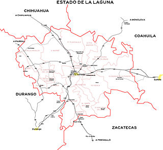
The Comarca Lagunera or La Comarca de la Laguna is a region of northern Mexico occupying large portions of the states of Durango and Coahuila, with rich soils produced by periodic flooding of the Nazas and Aguanaval rivers. Neither river drains into either the Pacific Ocean or the Gulf of Mexico, but rather they created a series of inland lakes. The region was developed for large-scale irrigated cotton agriculture. During the Mexican Revolution, the region was the site of fierce fighting. Following the military phase of the Revolution, the region was part of the agrarian reform under President Lázaro Cárdenas. The dam named for Cárdenas now controls flooding of the rivers, but the groundwater resources are no longer recharged as a result. It is the 8th largest metropolitan area in Mexico.

Sabana Grande de Palenque is a municipality (municipio) of the San Cristóbal province in the Dominican Republic.

Azua de Compostela, also known simply as Azua, is a municipality (municipio) and capital of Azua Province in the southern region of Dominican Republic. Founded in 1504, Azua is one of the oldest European settlements in the Americas. The town is located 100 kilometres west of the national capital, Santo Domingo.
San José de Ocoa, or simply Ocoa, is the capital of San José de Ocoa province in the Dominican Republic. It is located north of the Peravia province, and was part of that province until 1 January 2002.

Lolol is a Chilean commune and town in Colchagua Province, O'Higgins Region. Lolol was founded in 1830.

Monción is one of the 3 municipalities of the province in Santiago Rodriguez, Dominican Republic.
Teoloyucan is a city and municipality located in State of Mexico, Mexico. It lies 45 km north of the Federal District in the northeastern part of the state of México, and is part of the Greater Mexico City urban area. During the colonial period the area's name had a number of variations, including Teohuilloyocan, Teohuilloyucan, Theoloyucan, Teoloyucan Coaquileque and Tehuilloyocan. The name comes from Nahuatl meaning place of glass or place of crystal rock.
San Jose Villa de Allende is a town and seat of the municipality of Villa de Allende located 70 kilometers to the west of the city of Toluca. Villa de Allende was named in honor of Ignacio Allende, a hero of the Mexican War of Independence.
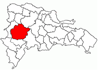
San Juan is a province of the Dominican Republic. Before 1961 it was known as Benefactor. San Juan is the Republic's largest province, bearing a size of 3,569 square kilometers, and it is landlocked.
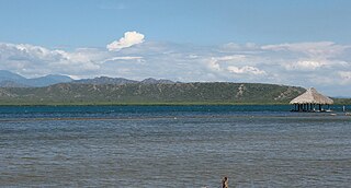
Sabana Yeguas is a barrio in the municipality of Lajas, Puerto Rico. Its population in 2010 was 2,082.
