Related Research Articles
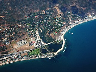
Malibu is a beach city in the Santa Monica Mountains region of Los Angeles County, California, about 30 miles (48 km) west of Downtown Los Angeles. It is known for its Mediterranean climate, its strip of beaches stretching 21 miles along the Pacific Ocean coast, and for its longtime status as the home of numerous affluent Hollywood celebrities and executives. Although a high proportion of its residents are entertainment industry figures with million-dollar mansions, Malibu also features several middle- and upper-middle-class neighborhoods. The Pacific Coast Highway traverses the city and has led most residents to settle anywhere from half a mile to within a few hundred yards of it, with some residents living up to one mile away from the beach in areas featuring narrow canyons. As of the 2020 census, the city's population was 10,654.

The Santa Monica Mountains are a coastal mountain range in Southern California, next to the Pacific Ocean. It is part of the Transverse Ranges. The Santa Monica Mountains National Recreation Area encompasses this mountain range. Because of its proximity to densely populated regions, it is one of the most visited natural areas in California.
The Santa Monica Mountains Conservancy is an agency of the state of California in the United States founded in 1980 and dedicated to the acquisition of land for preservation as open space, for wildlife and California native plants habitat Nature Preserves, and for public recreation activities.
The Los Angeles Westside is an urban region in western Los Angeles County, California, United States. It has no official definition, but sources like LA Weekly and the Mapping L.A. survey of the Los Angeles Times place the region on the western side of the Los Angeles Basin south of the Santa Monica Mountains.

Topanga is an unincorporated community in western Los Angeles County, California, United States. Located in the Santa Monica Mountains, the community exists in Topanga Canyon and the surrounding hills. The narrow southern portion of Topanga at the coast is between the city of Malibu and the Los Angeles neighborhood of Pacific Palisades. As of the 2020 census the population of the Topanga CDP was 8,560. For statistical purposes, the United States Census Bureau has defined Topanga as a census-designated place (CDP). The ZIP code is 90290 and the area code is primarily 310, with 818 only at the north end of the canyon. It is in the 3rd County Supervisorial district.
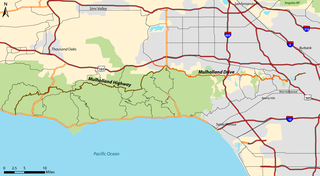
Mulholland Highway is a scenic road in Los Angeles County, California, that runs approximately 50 miles through the western Santa Monica Mountains from near US Route 101 in Calabasas to Highway 1 near Malibu at Leo Carrillo State Park and the Pacific Ocean coast – at the border of Los Angeles and Ventura Counties.

The Santa Monica Mountains National Recreation Area is a United States national recreation area containing many individual parks and open space preserves, located primarily in the Santa Monica Mountains of Southern California. The SMMNRA is in the greater Los Angeles region, with two thirds of the parklands in northwest Los Angeles County, and the remaining third, including a Simi Hills extension, in southeastern Ventura County.

Malibu Creek is a year-round stream in western Los Angeles County, California. It drains the southern Conejo Valley and Simi Hills, flowing south through the Santa Monica Mountains, and enters Santa Monica Bay in Malibu. The Malibu Creek watershed drains 109 square miles (280 km2) and its tributary creeks reach as high as 3,000 feet (910 m) into Ventura County. The creek's mainstem begins south of Westlake Village at the confluence of Triunfo Creek and Lobo Canyon Creek, and flows 13.4 miles (21.6 km) to Malibu Lagoon.

Founded in 1915, the Greater Los Angeles Area Council (GLAAC) (#033) served most of the City of Los Angeles as well as several other cities in the greater Los Angeles area. It was one of five Boy Scouts of America councils in Los Angeles County, California. Since its founding in 1915, the Los Angeles Area Council has brought its purpose and values to millions of youth. The Council served 54,567 youth in the Greater Los Angeles Area in 2008 alone.

Rancho San Vicente y Santa Mónica was a 33,000-acre (130 km2) Mexican land grant in present-day Los Angeles County, California given by governor Juan Alvarado in 1839 to Francisco Sepúlveda II, a soldier and citizen of Los Angeles. The rancho included what are now Santa Monica, Brentwood, Mandeville Canyon, and parts of West Los Angeles.

The Backbone Trail is a long-distance trail extending 67.79 miles (109.10 km) across the length of the Santa Monica Mountains in the U.S. state of California. Its western terminus is Point Mugu State Park, and its eastern terminus is Will Rogers State Historic Park in Pacific Palisades. The trail is open to hikers throughout its length. Dogs, mountain bicyclists and horseback riders are only allowed on portions of the trail as posted.
Leona Valley AVA is an American Viticulture Area (AVA) in northeastern Los Angeles County, California. It is located in Leona Valley within the Sierra Pelona Mountains of Southern California.
The Seiad Valley AVA is an American Viticultural Area in Siskiyou County, California, located adjacent to the Klamath River and close to the border with Oregon. The wine region was granted AVA status in 1994 despite having only one commercially bonded winery in operation, Seiad Valley Vineyards, which has since ceased operations. The valley floor is covered in the excavated rock left behind as tailings from gold mining. The exposed rocks absorb and retain heat from the sun, moderating the effects of a cool, mountain valley climate. There are approximately 3 acres (1 ha) of Riesling being grown inside the geographic boundaries of the AVA.

The Cucamonga Valley AVA is an American Viticultural Area in San Bernardino County, California. It is in the Cucamonga Valley region of the Pomona Valley, about 15 miles (24 km) west of San Bernardino.
The Malibu-Newton Canyon Valley AVA is an American Viticultural Area in Los Angeles County, California. The boundaries of the AVA include Newton Canyon, located about 4 miles (6 km) from the Pacific Ocean within the city limits of Malibu. George Rosenthal planted the first vineyards planted in the area since Prohibition in 1987, and was successful in his petition for the creation of the AVA in 1996. The canyon varies in elevation from 1,400 feet (427 m) to 2,800 feet (853 m) above sea level. Coastal fog and wind can influence the microclimate of the canyon, providing a cooler climate than the surrounding areas.

The Santa Ynez Valley AVA is an American Viticultural Area located in Santa Barbara County, California and was established on May 16, 1983 by the Alcohol and Tobacco Tax and Trade Bureau (TTB). It is part of the larger Central Coast AVA, and contains the greatest concentration of wineries in Santa Barbara County. The valley is formed by the Purisima Hills and San Rafael Mountains to the north and the Santa Ynez Mountains to the south creating a long, east-west corridor with very cool temperatures on the coast that become progressively warmer inland. The Santa Ynez River flows east to west on the valley floor toward the Pacific Ocean. As of 2021, the Santa Ynez Valley contains four other established viticultural areas: Sta. Rita Hills on its western boundary; Ballard Canyon and Los Olivos District occupying the center region; and Happy Canyon on the eastern border. Chardonnay is the most planted grape variety in the cooler, western portion of the valley while Rhône varieties thrive in the eastern locales.
Rancho Topanga Malibu Sequit was a 13,316-acre (53.89 km2) Spanish land grant in the Santa Monica Mountains and adjacent coast, within present day Los Angeles County, California. It was given by Spanish Governor José Joaquín de Arrillaga in 1804 to José Bartolomé Tapia.
God's Seat is a popular vista and rock formation in Malibu, California, United States, about two miles east of Circle X Ranch in the Santa Monica Mountains National Recreation Area. God's Seat's name derives from its natural throne-like shape at the top of a thousand-foot cliff. It is well known locally for its scenic views of Lake Sherwood, Sandstone Peak, the Conejo Valley and the Pacific Ocean.

Rancho Sierra Vista is one of the last intact ranches from the first half of the twentieth century in the Santa Monica Mountains. The majority of the landscape is much as it was 100 years ago. The area is now owned by the Santa Monica Mountains National Recreation Area, a unit of the National Park System.

Circle X Ranch is a park unit located in the Triunfo Pass within the southwestern Santa Monica Mountains National Recreation Area, in Ventura County, California. It is located in the western Santa Monica Mountains.
References
- ↑ Code of Federal Regulations. "§ 9.203 Saddle Rock-Malibu." Archived 2008-09-28 at the Wayback Machine Title 27: Alcohol, Tobacco and Firearms; Part 9 — American Viticultural Areas; Subpart C — Approved American Viticultural Areas. Retrieved Jan. 23, 2008.
- ↑ Wine Institute (2008). "The Appellations Of California Wine — Central Coast and Southern" Archived 2008-05-12 at the Wayback Machine . Retrieved Jan. 23, 2008.
34°05′50″N118°49′49″W / 34.097253°N 118.830206°W
| | This wine region article is a stub. You can help Wikipedia by expanding it. |