Saginaw, Missouri

Last updated

Saginaw, Missouri
Newton County Missouri Incorporated and Unincorporated areas Saginaw Highlighted.svg
Location of Saginaw, Missouri
Coordinates: 37°01′34″N94°28′21″W / 37.02611°N 94.47250°W / 37.02611; -94.47250
Country United States
State Missouri
County Newton
Area
[1]
  Total0.83 sq mi (2.14 km2)
  Land0.82 sq mi (2.14 km2)
  Water0.00 sq mi (0.01 km2)
Elevation
[2]
1,001 ft (305 m)
Population
 (2020)
  Total300
  Density363.64/sq mi (140.34/km2)
Time zone UTC-6 (Central (CST))
  Summer (DST) UTC-5 (CDT)
ZIP code
64864
Area code 417
FIPS code 29-63902 [3]
GNIS feature ID2399155 [2]

Saginaw is a village in Newton County, Missouri, United States. The population was 297 at the 2010 census. It is part of the Joplin, Missouri Metropolitan Statistical Area.

Contents

Geography

According to the United States Census Bureau, the village has a total area of 0.83 square miles (2.15 km2), all land. [4]

The terrain is rolling hills and bluffs and features the Ozark hickory and oak forest which are typical of the region. Shoal Creek, the third-largest tributary of the ecologically important Spring River watershed, straddles its southern boundary.[ citation needed ]

History

Saginaw was originally named Thurman, after one Mr. Thurman the proprietor of a local country store. [5] A post office called Thurman was established in 1873, and the name was changed to Saginaw in 1889. [6] The present name is after Saginaw, Michigan. [5]

Demographics

Historical population
CensusPop.Note
1960 188
1970 22419.1%
1980 29330.8%
1990 38431.1%
2000 276−28.1%
2010 2977.6%
2020 3001.0%
U.S. Decennial Census

2010 census

As of the census [7] of 2010, there were 297 people, 129 households, and 81 families living in the village. The population density was 357.8 inhabitants per square mile (138.1/km2). There were 138 housing units at an average density of 166.3 per square mile (64.2/km2). The racial makeup of the village was 94.3% White, 0.3% African American, 3.4% Native American, 0.3% Pacific Islander, 0.3% from other races, and 1.3% from two or more races. Hispanic or Latino of any race were 2.0% of the population.

There were 129 households, of which 26.4% had children under the age of 18 living with them, 49.6% were married couples living together, 9.3% had a female householder with no husband present, 3.9% had a male householder with no wife present, and 37.2% were non-families. 24.8% of all households were made up of individuals, and 4.6% had someone living alone who was 65 years of age or older. The average household size was 2.30 and the average family size was 2.80.

The median age in the village was 45.2 years. 20.2% of residents were under the age of 18; 5.4% were between the ages of 18 and 24; 24% were from 25 to 44; 36.1% were from 45 to 64; and 14.5% were 65 years of age or older. The gender makeup of the village was 53.2% male and 46.8% female.

2000 census

As of the census [3] of 2000, there were 276 people, 115 households, and 77 families living in the village. The population density was 337.2 inhabitants per square mile (130.2/km2). There were 126 housing units at an average density of 153.9 per square mile (59.4/km2). The racial makeup of the village was 93.12% White, 0.72% African American, 3.99% Native American, and 2.17% from two or more races. Hispanic or Latino of any race were 1.09% of the population.

There were 115 households, out of which 27.0% had children under the age of 18 living with them, 60.0% were married couples living together, 5.2% had a female householder with no husband present, and 32.2% were non-families. 23.5% of all households were made up of individuals, and 6.1% had someone living alone who was 65 years of age or older. The average household size was 2.40 and the average family size was 2.88.

In the village, the population was spread out, with 22.1% under the age of 18, 6.2% from 18 to 24, 31.2% from 25 to 44, 27.9% from 45 to 64, and 12.7% who were 65 years of age or older. The median age was 41 years. For every 100 females, there were 94.4 males. For every 100 females age 18 and over, there were 104.8 males.

The median income for a household in the village was $42,083, and the median income for a family was $51,250. Males had a median income of $31,250 versus $21,250 for females. The per capita income for the village was $22,639. About 7.2% of families and 9.1% of the population were below the poverty line, including 8.7% of those under the age of eighteen and 19.4% of those 65 or over.

Related Research Articles

<span class="mw-page-title-main">Essexville, Michigan</span> City in Michigan, United States

Essexville is a city in Bay County in the U.S. state of Michigan. The population was 3,379 at the 2020 census. Located along the Saginaw River, Essexville is part of the Saginaw, Midland, and Bay City metropolitan area.

<span class="mw-page-title-main">Merrill, Michigan</span> Village in Michigan, United States

Merrill is a village in Saginaw County in the U.S. state of Michigan. The population was 663 at the 2020 census. The village is located within Jonesfield Township.

<span class="mw-page-title-main">Saginaw Charter Township, Michigan</span> Charter township in Michigan, United States

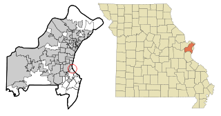
Saginaw Charter Township is a charter township of Saginaw County in the U.S. state of Michigan. The population was 41,679 at the 2020 census. The city of Saginaw is adjacent to the township to the southeast, but is administratively autonomous.

<span class="mw-page-title-main">Big Lake, Missouri</span> Village in Missouri, United States

Big Lake is a village in Holt County, Missouri, United States. The population was 65 at the 2020 census.

<span class="mw-page-title-main">River Bend, Missouri</span> Village in Missouri, United States

River Bend is a village in Jackson County, Missouri, United States. The population was 3 at the 2020 census. It is the only part of Jackson County that lies north of the Missouri River. In 1951, the Missouri River was relocated to a new channel, creating River Bend,. The county line still follows the original riverbed. It is part of the Kansas City metropolitan area. The mayor is Alex Dockler.

<span class="mw-page-title-main">Evergreen, Missouri</span> Village in Missouri, United States

Evergreen is a village in Laclede County, Missouri, United States. The population was 28 at the 2010 census. It was named Twin Bridges at the 2000 census.

<span class="mw-page-title-main">Bakersfield, Missouri</span> Village in Missouri, United States

Bakersfield is a village in southeastern Ozark County in the Ozarks of southern Missouri, United States. The population was 186 at the 2020 census.

<span class="mw-page-title-main">Roscoe, Missouri</span> Village in Missouri, United States

Roscoe is a village in St. Clair County, Missouri, United States. The population was 89 at the 2020 census.

<span class="mw-page-title-main">Country Life Acres, Missouri</span> Village in Missouri, United States

Country Life Acres is a village in St. Louis County, Missouri, United States. The population was 72 at the 2020 census.

<span class="mw-page-title-main">Glen Echo Park, Missouri</span> Former Village in Missouri, United States

Glen Echo Park was a village in St. Louis County, Missouri, United States. The population was 122 at the 2020 census. The community took its name from the nearby Glen Echo Country Club.

<span class="mw-page-title-main">Grantwood Village, Missouri</span> Town in Missouri, United States

Grantwood Village is a town in St. Louis County, Missouri, United States. The population was 863 at the 2010 census.

<span class="mw-page-title-main">Hillsdale, Missouri</span> Village in Missouri, United States

Hillsdale is a village in St. Louis County, Missouri, United States. Greenwood Cemetery is located in Hillsdale. The population was 1,478 at the 2010 census.

<span class="mw-page-title-main">Mackenzie, Missouri</span> Village in Missouri, United States

Mackenzie is an unincorporated community in St. Louis County, Missouri, United States. The population was 134 at the 2010 census.

<span class="mw-page-title-main">Marlborough, Missouri</span> Village in Missouri, United States

Marlborough is a village in St. Louis County, Missouri, United States. The population was 2,179 at the 2010 census.

<span class="mw-page-title-main">Pasadena Park, Missouri</span> Village in Missouri, United States

Pasadena Park is a village in St. Louis County, Missouri, United States. The population was 470 at the 2010 census. It is part of the Normandy School District, and is distinct from the city of Pasadena Hills.

<span class="mw-page-title-main">Westwood, Missouri</span> Village in Missouri, United States

Westwood is a village in west St. Louis County, Missouri, United States. The population was 316 at the 2020 census.

<span class="mw-page-title-main">Silver Creek, Missouri</span> Neighborhood in Newton, Missouri, United States

Silver Creek was a village in Newton County, Missouri, United States. The population was 623 at the 2010 census. It is part of the Joplin, Missouri Metropolitan Statistical Area. On August 7, 2012, residents of the Village of Silver Creek and the City of Joplin voted to consolidate and become part of the city of Joplin.

<span class="mw-page-title-main">Champ, Missouri</span> Village in Missouri, United States

Champ is a village in St. Louis County, Missouri, United States. The population was 10 at the 2020 census.

<span class="mw-page-title-main">Hanley Hills, Missouri</span> Village in Missouri, United States

Hanley Hills is a village in St. Louis County, Missouri, United States. The population was 2,101 at the 2010 census.

<span class="mw-page-title-main">Centerville, Gallia County, Ohio</span> Village in Ohio, United States

Centerville, also known as Thurman, is a city in western Gallia County, Ohio, United States. The city lies adjacent to the Gallia - Jackson county line. It is located adjacent to U.S. Route 35 at the eastern terminus of State Route 279.

References

  1. "ArcGIS REST Services Directory". United States Census Bureau. Retrieved August 28, 2022.
  2. 1 2 U.S. Geological Survey Geographic Names Information System: Saginaw, Missouri
  3. 1 2 "U.S. Census website". United States Census Bureau . Retrieved January 31, 2008.
  4. "US Gazetteer files 2010". United States Census Bureau. Archived from the original on July 2, 2012. Retrieved July 8, 2012.
  5. 1 2 "Newton County Place Names, 1928–1945". The State Historical Society of Missouri. Archived from the original on June 24, 2016. Retrieved November 22, 2016.
  6. "Post Offices". Jim Forte Postal History. Retrieved November 22, 2016.
  7. "U.S. Census website". United States Census Bureau . Retrieved July 8, 2012.