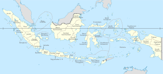
Provinces are the first-level administrative divisions of Indonesia. It is formerly called the first-level provincial region before the Reform era. Provinces have a local government, consisting of a governor and a regional legislative body. The governor and members of local representative bodies are elected by popular vote for five-year terms, but governors can only serve for two terms. Provincial governments have the authority to regulate and manage their own government affairs, subject to the limits of the central government.
Jayapura is the capital and largest city of the Indonesian province of Papua. It is situated on the northern coast of New Guinea island and covers an area of 940.0 km2 (362.9 sq mi). The city borders the Pacific Ocean and Yos Sudarso Bay to the north, the country of Papua New Guinea to the east, Keerom Regency to the south, and Jayapura Regency to the west.

Bogor is a city in the West Java province, Indonesia. Located around 60 kilometers (37 mi) south of the national capital of Jakarta, Bogor is the 6th largest city in the Jakarta metropolitan area and the 14th overall nationwide. The city covers an area of 111.39 km2, and it had a population of 950,334 in the 2010 Census and 1,043,070 in the 2020 Census. The official estimate as at the end of 2023 was 1,127,408. Bogor is an important economic, scientific, cultural, and tourist center, as well as a mountain resort.

Cilegon is a major coastal industrial city in Banten province, Indonesia, covering 162.51 km2 (62.75 sq mi). It is located on the island of Java. The city had a population of 374,464 at the 2010 Census and 434,896 at the 2020 Census; the official estimate as at mid 2023 was 450,507 - comprising 228,360 males and 222,150 females.
East Jakarta is the largest of the five administrative cities which form the Special Capital Region of Jakarta, Indonesia. It had a population of 2,693,896 at the 2010 Census and 3,037,139 at the 2020 Census; the official estimate as at mid 2022 was 3,083,883, making it the most populous of the five administrative cities within Jakarta. East Jakarta is not self-governed and does not have a city council, hence it is not classified as a proper municipality.
Indonesia is divided into provinces. Provinces are made up of regencies and cities (kota). Provinces, regencies, and cities have their own local governments and parliamentary bodies.

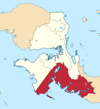
Merauke Regency is a regency in the far south of the Indonesian province of South Papua. It covers an area of 45,025.91 km2, and had a population of 195,716 at the 2010 Census and 230,932 at the 2020 Census; the official estimate as at mid 2022 was 232,357, comprising 121,237 males and 111,120 females. The administrative centre is the town of Merauke; this was projected since 2013 to become an independent city (kota) separate from Merauke Regency, but the alteration has been deferred. It is also the provincial capital of the province of South Papua, more specifically in Salor located in Kurik District. Merauke is the largest regency in Indonesia, with an area of 45,026 km2, slightly larger than Estonia.

Sorong is the largest city and the capital of the Indonesian province of Southwest Papua. The city is located on the western tip of the island of New Guinea with its only land borders being with Sorong Regency. It is the gateway to Indonesia's Raja Ampat Islands, species rich coral reef islands in an area considered the heart of the world's coral reef biodiversity. It also is the logistics hub for Indonesia's thriving eastern oil and gas frontier. Sorong has experienced exponential growth since 2010, and further growth is anticipated as Sorong becomes linked by road to other frontier towns in Papua's Bird's Head Peninsula.

Kota Tua Jakarta, officially known as Kota Tua, is a neighborhood comprising the original downtown area of Jakarta, Indonesia. It is also known as Oud Batavia, Benedenstad, or Kota Lama.
Pagar Alam, is a city in South Sumatra, Indonesia. It was formerly part of Lahat Regency, from which it was separated as an independent city on 21 June 2001; before being established as an independent city, Pagar Alam was an administrative city within Lahat Regency. It has an area of 633.66 km2 and a population of 126,181 at the 2010 Census and 143,844 at the 2020 Census; the official estimate as at mid 2022 was 147,071.

South Tangerang is a city in the province of Banten, Indonesia. Located 30 km (19 mi) on the southwestern border of Jakarta, the city forms part of the Greater Jakarta metropolitan area. It was administratively separated from Tangerang Regency on 26 November 2008. According to the 2020 Census, the city population was 1,354,350 inhabitants, while the official estimate as at mid 2023 was 1,404,785 - comprising 700,754 males and 704,031 females. The total area is 164.85 km2 (63.65 sq mi). It is the second-largest city in Banten in terms of population, and has grown rapidly, not only as Jakarta's satellite city, but also the development of business districts and commerce due to presence of large-scale planned town by private developers.
Cikarang is a town serving the seat of Bekasi Regency, West Java, Indonesia. The biggest industrial estate in Southeast Asia, Kota Jababeka is located there.
Kaimana Regency is a regency in the south of West Papua province of Indonesia. It covers an area of 18,500 sq. km, and had a population of 46,249 at the 2010 Census and 62,256 at the 2020 Census; the official estimate as at mid 2022 was 63,633. The administrative centre is the town of Kaimana. The Mairasi languages are spoken in the regency, among other languages.

Tanjung Selor is the capital of both the North Kalimantan province in Indonesia, and of the Bulungan Regency. It is among provincial capitals in Indonesia that as of 2021 does not yet have city status, together with Mamuju in West Sulawesi, Sofifi in North Maluku, Wanggar in Central Papua, Wamena in Highland Papua, Salor in South Papua, and Manokwari in West Papua. The district has an area of 677.77 km2 and had a population of 39,439 at the 2010 Census and 56,569 at the 2020 Census.

Tual is a city in Maluku Province of Indonesia, geographically located within the Kei Islands. On 17 July 2007, it was separated from the rest of the Kei Islands and was created an independent city.
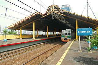
Gondangdia Station (GDD) is a railway station serving by Jakarta Commuterline at Gondangdia, Menteng, Central Jakarta, Indonesia.

PT Indomarco Prismatama or Indomaret is a chain of retail convenience stores from Indonesia, with over 21,900 stores in 32 provinces across Indonesia. It is the first and largest chain of this kind of store in Indonesia. Indomaret is predominantly owned by Indoritel and headquartered in Jakarta.

Sudirman Central Business District, abbreviated and locally known as SCBD, is a business district with an integrated mixed-use development concept, located in Sudirman Avenue, South Jakarta, Indonesia, with many skyscrapers consisting of condominiums, office buildings, hotels, shopping and entertainment centers. The area is considered to be the epicentrum of business in the country, with office spaces inhabited by multinational companies.
South Papua, officially the South Papua Province, is an Indonesian province located in the southern portion of Papua, following the borders of the Papuan customary region of Anim Ha. Formally established on 11 November 2022 and including the four most southern regencies that were previously part of the province of Papua and before 11 December 2002 had comprised a larger Merauke Regency, it covers a land area of 117,849.16 km2, about the same area as Pennsylvania. This area had a population of 513,617 at the 2020 Census, while the official estimate as at mid 2023 was 534,416, making it the least populous province in Indonesia.

Central Papua, officially the Central Papua Province is an Indonesian province located in the central region of Western New Guinea. It was formally established on 11 November 2022 from the former eight western regencies of the province of Papua. It covers an area of 61,072.92 km2 and had an officially estimated population of 1,430,951 in mid 2022. It is bordered by the Indonesian provinces of West Papua to the west, the residual province of Papua to the north and northeast, by Highland Papua to the east. and by South Papua to the southeast. The administrative capital is located in Wanggar District in Nabire Regency, although Timika is a larger town.

